Moneta Sw Topo Map Virginia
To zoom in, hover over the map of Moneta Sw
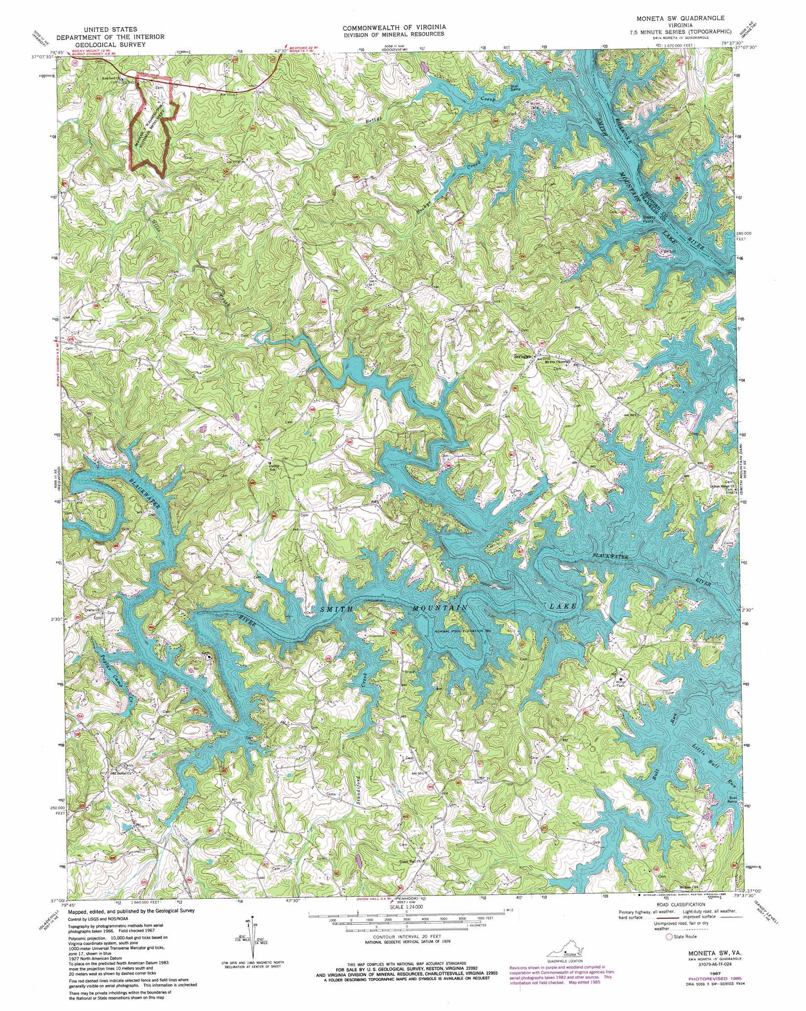
USGS Topo Quad 37079a6 - 1:24,000 scale
| Topo Map Name: | Moneta Sw |
| USGS Topo Quad ID: | 37079a6 |
| Print Size: | ca. 21 1/4" wide x 27" high |
| Southeast Coordinates: | 37° N latitude / 79.625° W longitude |
| Map Center Coordinates: | 37.0625° N latitude / 79.6875° W longitude |
| U.S. State: | VA |
| Filename: | o37079a6.jpg |
| Download Map JPG Image: | Moneta Sw topo map 1:24,000 scale |
| Map Type: | Topographic |
| Topo Series: | 7.5´ |
| Map Scale: | 1:24,000 |
| Source of Map Images: | United States Geological Survey (USGS) |
| Alternate Map Versions: |
Moneta SW VA 1967, updated 1970 Download PDF Buy paper map Moneta SW VA 1967, updated 1986 Download PDF Buy paper map Moneta SW VA 2012 Download PDF Buy paper map Moneta SW VA 2013 Download PDF Buy paper map Moneta SW VA 2016 Download PDF Buy paper map |
1:24,000 Topo Quads surrounding Moneta Sw
Roanoke |
Stewartsville |
Irving |
Bedford |
Goode |
Garden City |
Hardy |
Goodview |
Moneta |
Huddleston |
Boones Mill |
Redwood |
Moneta Sw |
Smith Mountain Dam |
Leesville |
Rocky Mount |
Gladehill |
Penhook |
Sandy Level |
Pittsville |
Bassett |
Snow Creek |
Mountain Valley |
Callands |
Chatham |
> Back to 37079a1 at 1:100,000 scale
> Back to 37078a1 at 1:250,000 scale
> Back to U.S. Topo Maps home
Moneta Sw topo map: Gazetteer
Moneta Sw: Airports
Brammer Seaplane Base elevation 263m 862′Moneta Sw: Capes
Breezy Point elevation 243m 797′Moneta Sw: Crossings
Crafts Ford elevation 254m 833′Greers Ford elevation 242m 793′
Radfords Ford elevation 242m 793′
Moneta Sw: Dams
Bernard Dam elevation 263m 862′Moneta Sw: Parks
Booker T Washington National Monument elevation 289m 948′Penhook State Boat Ramp elevation 243m 797′
Moneta Sw: Populated Places
Arrowhead elevation 253m 830′Crafts Point elevation 263m 862′
Foxsport elevation 256m 839′
Isle of Pines elevation 281m 921′
North Shore elevation 306m 1003′
Pelican Point elevation 252m 826′
Scruggs elevation 308m 1010′
Smiths Paradise elevation 265m 869′
The Waterfront elevation 247m 810′
Union Hall elevation 279m 915′
Westlake Corner elevation 286m 938′
White Pine elevation 255m 836′
Moneta Sw: Streams
Beckys Creek elevation 242m 793′Bettys Creek elevation 242m 793′
Bull Run elevation 242m 793′
Gills Creek elevation 242m 793′
Little Bull Run elevation 242m 793′
Poplar Camp Creek elevation 242m 793′
Standiford Creek elevation 242m 793′
Moneta Sw digital topo map on disk
Buy this Moneta Sw topo map showing relief, roads, GPS coordinates and other geographical features, as a high-resolution digital map file on DVD:
Western Virginia & Southern West Virginia
Buy digital topo maps: Western Virginia & Southern West Virginia