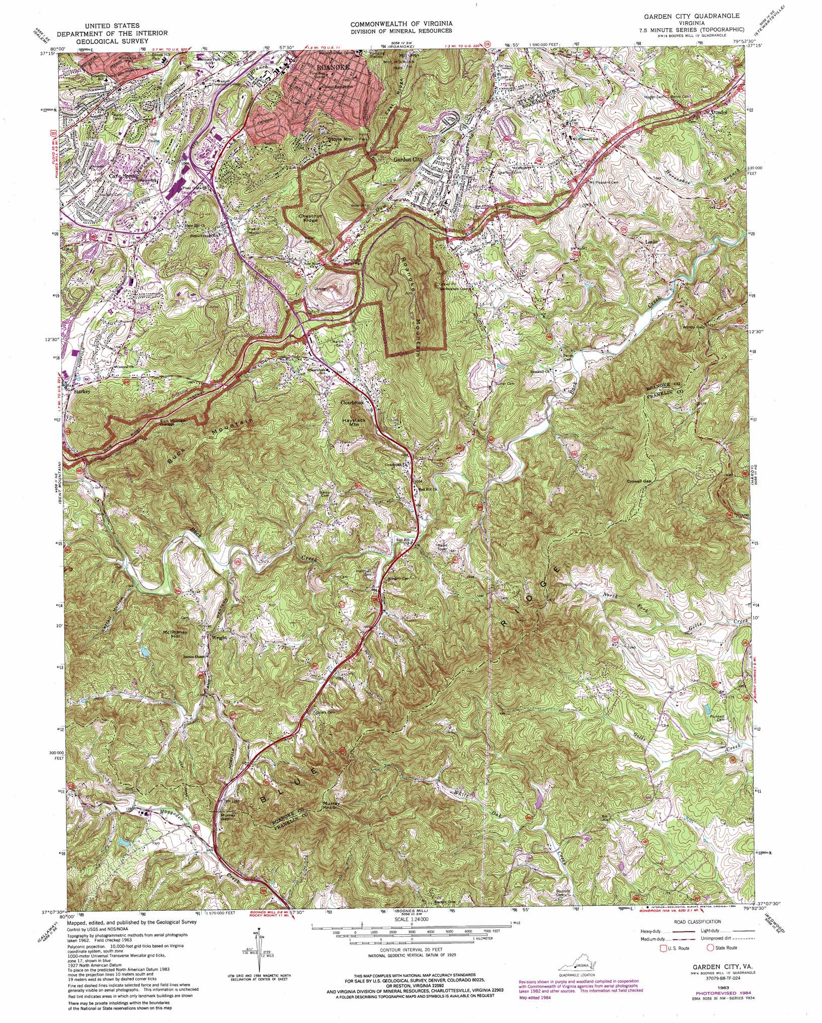
Garden City Topo Map Virginia
To zoom in, hover over the map of Garden City
USGS Topo Quad 37079b8 - 1:24,000 scale
| Topo Map Name: | Garden City |
| USGS Topo Quad ID: | 37079b8 |
| Print Size: | ca. 21 1/4" wide x 27" high |
| Southeast Coordinates: | 37.125° N latitude / 79.875° W longitude |
| Map Center Coordinates: | 37.1875° N latitude / 79.9375° W longitude |
| U.S. State: | VA |
| Filename: | o37079b8.jpg |
| Download Map JPG Image: | Garden City topo map 1:24,000 scale |
| Map Type: | Topographic |
| Topo Series: | 7.5´ |
| Map Scale: | 1:24,000 |
| Source of Map Images: | United States Geological Survey (USGS) |
| Alternate Map Versions: |
Garden City VA 1963, updated 1965 Download PDF Buy paper map Garden City VA 1963, updated 1969 Download PDF Buy paper map Garden City VA 1963, updated 1978 Download PDF Buy paper map Garden City VA 1977, updated 1983 Download PDF Buy paper map Garden City VA 1984 Download PDF Buy paper map Garden City VA 1999, updated 2000 Download PDF Buy paper map Garden City VA 2011 Download PDF Buy paper map Garden City VA 2013 Download PDF Buy paper map Garden City VA 2016 Download PDF Buy paper map |
1:24,000 Topo Quads surrounding Garden City
Looney |
Catawba |
Daleville |
Villamont |
Montvale |
Glenvar |
Salem |
Roanoke |
Stewartsville |
Irving |
Elliston |
Bent Mountain |
Garden City |
Hardy |
Goodview |
Check |
Callaway |
Boones Mill |
Redwood |
Moneta Sw |
Endicott |
Ferrum |
Rocky Mount |
Gladehill |
Penhook |
> Back to 37079a1 at 1:100,000 scale
> Back to 37078a1 at 1:250,000 scale
> Back to U.S. Topo Maps home
Garden City topo map: Gazetteer
Garden City: Dams
Bowmans Dam elevation 350m 1148′Garden City: Gaps
Crowell Gap elevation 596m 1955′Maggotty Gap elevation 343m 1125′
Murray Gap elevation 382m 1253′
Windy Gap elevation 376m 1233′
Garden City: Parks
Brambleton Park elevation 342m 1122′Fern Park elevation 346m 1135′
Fishburn Park elevation 356m 1167′
Garden City Recreation Building elevation 349m 1145′
Woodland Park elevation 336m 1102′
Garden City: Populated Places
Algoma Park elevation 359m 1177′Beechwood Gardens elevation 319m 1046′
Beulah Heights elevation 354m 1161′
Brambleton Court elevation 328m 1076′
Branderwood elevation 367m 1204′
Castle Hill elevation 353m 1158′
Chapel Forest elevation 463m 1519′
Chesterfield elevation 388m 1272′
Chestnut Hills elevation 408m 1338′
Clearbrook elevation 342m 1122′
Clermont Heights elevation 351m 1151′
Cobleshaw elevation 350m 1148′
Crescent Heights elevation 371m 1217′
Crystal Spring elevation 332m 1089′
Dundee elevation 346m 1135′
East Pointe elevation 362m 1187′
Edgehill elevation 359m 1177′
Edgehill Estates elevation 395m 1295′
Englewood elevation 398m 1305′
Fralin Park elevation 327m 1072′
Garden City elevation 319m 1046′
Georgetown Park elevation 354m 1161′
Glenmont elevation 371m 1217′
Glenwood Estates elevation 313m 1026′
Grandin Court elevation 349m 1145′
Green Valley elevation 346m 1135′
Greenland Hills elevation 340m 1115′
Greenwood Forest elevation 372m 1220′
Hampden Hills elevation 322m 1056′
Homeland Hills elevation 329m 1079′
Hunting Hills elevation 387m 1269′
Jefferson Hills elevation 357m 1171′
Jefferson Park elevation 355m 1164′
Leslie elevation 310m 1017′
Meadowlark elevation 355m 1164′
Mill Mountain Estates elevation 315m 1033′
Mount Pleasant elevation 347m 1138′
Narrows elevation 370m 1213′
Ogden Hills elevation 354m 1161′
Parkway Acres elevation 425m 1394′
Parkway Meadows elevation 331m 1085′
Peakwood Hills elevation 386m 1266′
Pinkard Court elevation 353m 1158′
Prospect Hills elevation 335m 1099′
Prospect Valley elevation 333m 1092′
Richart Heights elevation 356m 1167′
Rockingham Court elevation 335m 1099′
Rorer Mines (historical) elevation 394m 1292′
Ruxton elevation 373m 1223′
Sherwood Forest elevation 352m 1154′
Southern Hills elevation 407m 1335′
Southern Pines elevation 396m 1299′
Spring Valley elevation 331m 1085′
Starkey elevation 347m 1138′
Suncrest Heights elevation 394m 1292′
Wildwood elevation 351m 1151′
Woodcliff elevation 335m 1099′
Woods Crossing elevation 358m 1174′
Wright elevation 332m 1089′
Yellowstone elevation 373m 1223′
Yostland Heights elevation 356m 1167′
Garden City: Reservoirs
Bowmans Pond elevation 350m 1148′Garden City: Ridges
Chestnut Ridge elevation 518m 1699′East Ridge elevation 448m 1469′
Garden City: Springs
Crystal Spring elevation 287m 941′Garden City: Streams
Gum Spring Branch elevation 296m 971′Garden City: Summits
Buck Mountain elevation 598m 1961′Haystack Mountain elevation 502m 1646′
McIlhaney Hill elevation 500m 1640′
Mill Mountain elevation 516m 1692′
Murray Knob elevation 695m 2280′
Roanoke Mountain elevation 662m 2171′
Stone Mountain elevation 488m 1601′
Garden City: Valleys
Cattail Hollow elevation 315m 1033′Garden City digital topo map on disk
Buy this Garden City topo map showing relief, roads, GPS coordinates and other geographical features, as a high-resolution digital map file on DVD:
Western Virginia & Southern West Virginia
Buy digital topo maps: Western Virginia & Southern West Virginia