Goode Topo Map Virginia
To zoom in, hover over the map of Goode
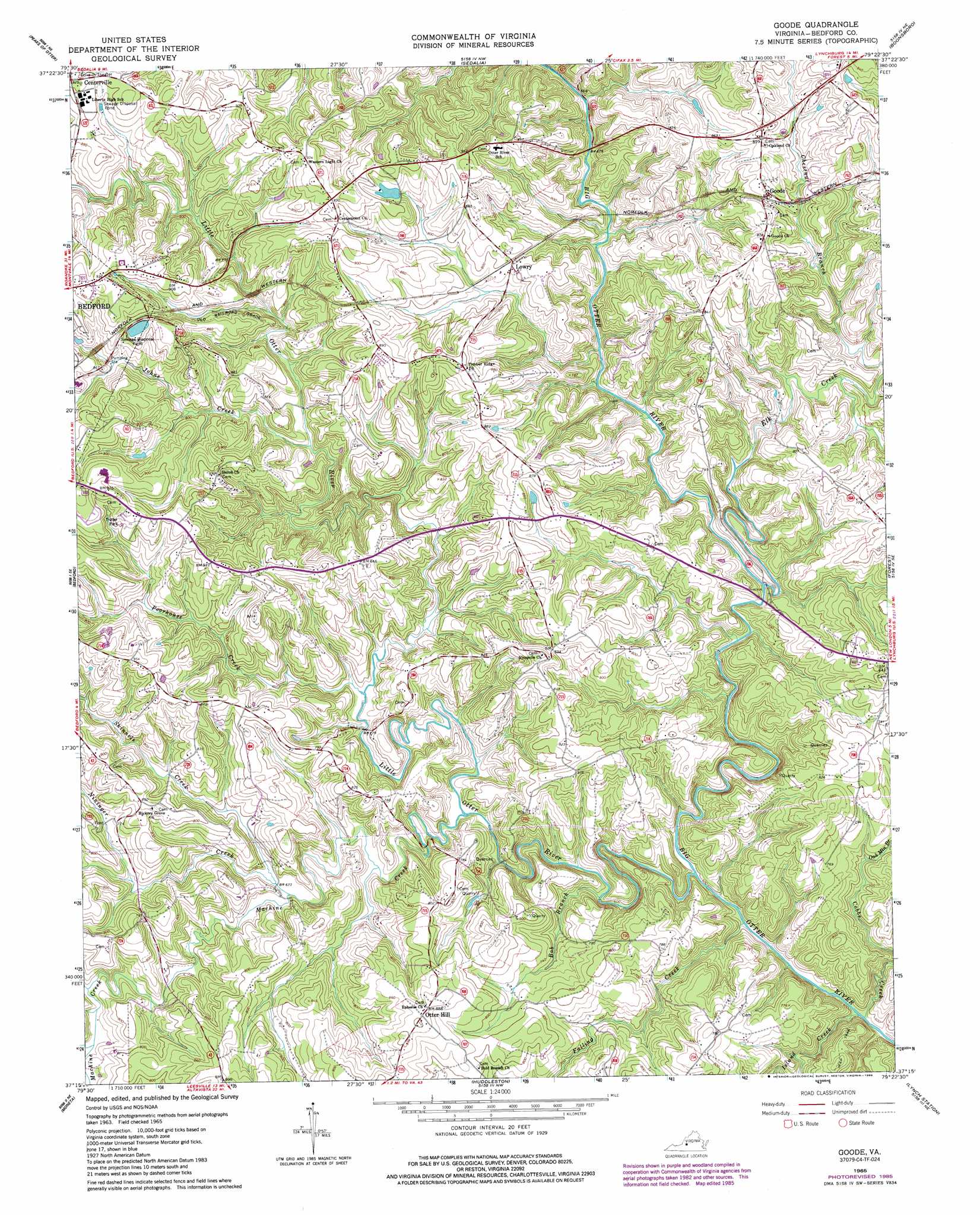
USGS Topo Quad 37079c4 - 1:24,000 scale
| Topo Map Name: | Goode |
| USGS Topo Quad ID: | 37079c4 |
| Print Size: | ca. 21 1/4" wide x 27" high |
| Southeast Coordinates: | 37.25° N latitude / 79.375° W longitude |
| Map Center Coordinates: | 37.3125° N latitude / 79.4375° W longitude |
| U.S. State: | VA |
| Filename: | o37079c4.jpg |
| Download Map JPG Image: | Goode topo map 1:24,000 scale |
| Map Type: | Topographic |
| Topo Series: | 7.5´ |
| Map Scale: | 1:24,000 |
| Source of Map Images: | United States Geological Survey (USGS) |
| Alternate Map Versions: |
Goode VA 1965, updated 1967 Download PDF Buy paper map Goode VA 1965, updated 1978 Download PDF Buy paper map Goode VA 1965, updated 1986 Download PDF Buy paper map Goode VA 1965, updated 1986 Download PDF Buy paper map Goode VA 2010 Download PDF Buy paper map Goode VA 2013 Download PDF Buy paper map Goode VA 2016 Download PDF Buy paper map |
1:24,000 Topo Quads surrounding Goode
Buchanan |
Arnold Valley |
Snowden |
Big Island |
Tobacco Row Mountain |
Montvale |
Peaks Of Otter |
Sedalia |
Boonsboro |
Lynchburg |
Irving |
Bedford |
Goode |
Forest |
City Farm |
Goodview |
Moneta |
Huddleston |
Lynch Station |
Castle Craig |
Moneta Sw |
Smith Mountain Dam |
Leesville |
Altavista |
Straightstone |
> Back to 37079a1 at 1:100,000 scale
> Back to 37078a1 at 1:250,000 scale
> Back to U.S. Topo Maps home
Goode topo map: Gazetteer
Goode: Airports
Windy Ridge Airport elevation 236m 774′Goode: Dams
Markham Dam elevation 265m 869′Goode: Populated Places
Centerville elevation 282m 925′Goode elevation 243m 797′
Lowry elevation 246m 807′
Otter Hill elevation 273m 895′
Goode: Reservoirs
Markham Pond elevation 265m 869′Goode: Streams
Bob Branch elevation 183m 600′Bunker Hill Creek elevation 216m 708′
Cobbs Creek elevation 176m 577′
Elk Creek elevation 188m 616′
Falling Creek elevation 176m 577′
Island Creek elevation 176m 577′
Johns Creek elevation 220m 721′
Little Otter River elevation 178m 583′
Machine Creek elevation 192m 629′
Nininger Creek elevation 192m 629′
Oak Mountain Branch elevation 206m 675′
Poorhouse Creek elevation 202m 662′
Skinnels Creek elevation 204m 669′
Wells Creek elevation 215m 705′
Goode digital topo map on disk
Buy this Goode topo map showing relief, roads, GPS coordinates and other geographical features, as a high-resolution digital map file on DVD:
Western Virginia & Southern West Virginia
Buy digital topo maps: Western Virginia & Southern West Virginia