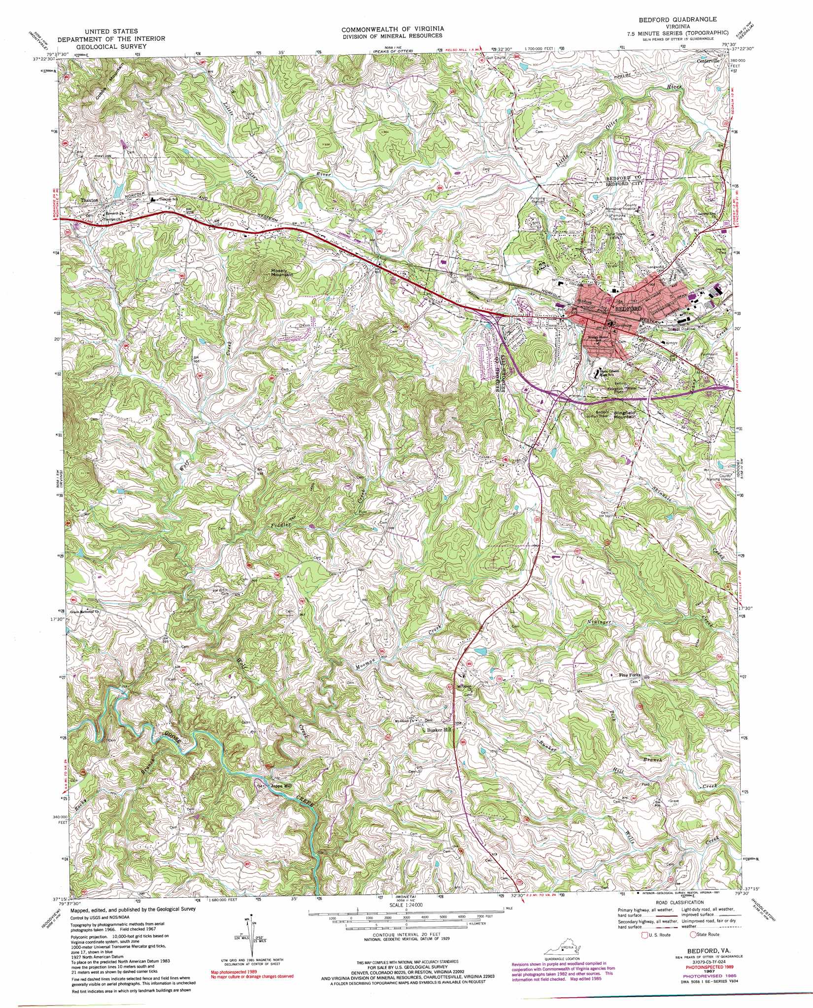
Bedford Topo Map Virginia
To zoom in, hover over the map of Bedford
USGS Topo Quad 37079c5 - 1:24,000 scale
| Topo Map Name: | Bedford |
| USGS Topo Quad ID: | 37079c5 |
| Print Size: | ca. 21 1/4" wide x 27" high |
| Southeast Coordinates: | 37.25° N latitude / 79.5° W longitude |
| Map Center Coordinates: | 37.3125° N latitude / 79.5625° W longitude |
| U.S. State: | VA |
| Filename: | o37079c5.jpg |
| Download Map JPG Image: | Bedford topo map 1:24,000 scale |
| Map Type: | Topographic |
| Topo Series: | 7.5´ |
| Map Scale: | 1:24,000 |
| Source of Map Images: | United States Geological Survey (USGS) |
| Alternate Map Versions: |
Bedford VA 1967, updated 1970 Download PDF Buy paper map Bedford VA 1967, updated 1978 Download PDF Buy paper map Bedford VA 1967, updated 1986 Download PDF Buy paper map Bedford VA 1967, updated 1991 Download PDF Buy paper map Bedford VA 2010 Download PDF Buy paper map Bedford VA 2013 Download PDF Buy paper map Bedford VA 2016 Download PDF Buy paper map |
1:24,000 Topo Quads surrounding Bedford
Salisbury |
Buchanan |
Arnold Valley |
Snowden |
Big Island |
Villamont |
Montvale |
Peaks Of Otter |
Sedalia |
Boonsboro |
Stewartsville |
Irving |
Bedford |
Goode |
Forest |
Hardy |
Goodview |
Moneta |
Huddleston |
Lynch Station |
Redwood |
Moneta Sw |
Smith Mountain Dam |
Leesville |
Altavista |
> Back to 37079a1 at 1:100,000 scale
> Back to 37078a1 at 1:250,000 scale
> Back to U.S. Topo Maps home
Bedford topo map: Gazetteer
Bedford: Airports
Hospital Heliport elevation 282m 925′Robinson Private Airport elevation 290m 951′
Bedford: Parks
Bedford Historic District elevation 299m 980′Bedford: Pillars
Bedford Lookout Tower elevation 386m 1266′Bedford: Populated Places
Bedford elevation 306m 1003′Bunker Hill elevation 322m 1056′
Five Forks elevation 298m 977′
Joppa Mill elevation 220m 721′
North Hills elevation 286m 938′
Northwood Heights elevation 283m 928′
Robertsons (historical) elevation 284m 931′
Thaxton elevation 289m 948′
Town and Country elevation 295m 967′
Bedford: Post Offices
Bedford Post Office elevation 304m 997′Bedford: Streams
Fiddler Creek elevation 238m 780′Middle Fork Little Otter Creek elevation 256m 839′
Mooman Creek elevation 223m 731′
Rocky Branch elevation 223m 731′
South Fork Little Otter Creek elevation 255m 836′
Tick Branch elevation 230m 754′
Wolf Creek elevation 217m 711′
Bedford: Summits
Cobbs Mountain elevation 416m 1364′Mosely Mountain elevation 379m 1243′
Wingfield Mountain elevation 385m 1263′
Bedford digital topo map on disk
Buy this Bedford topo map showing relief, roads, GPS coordinates and other geographical features, as a high-resolution digital map file on DVD:
Western Virginia & Southern West Virginia
Buy digital topo maps: Western Virginia & Southern West Virginia