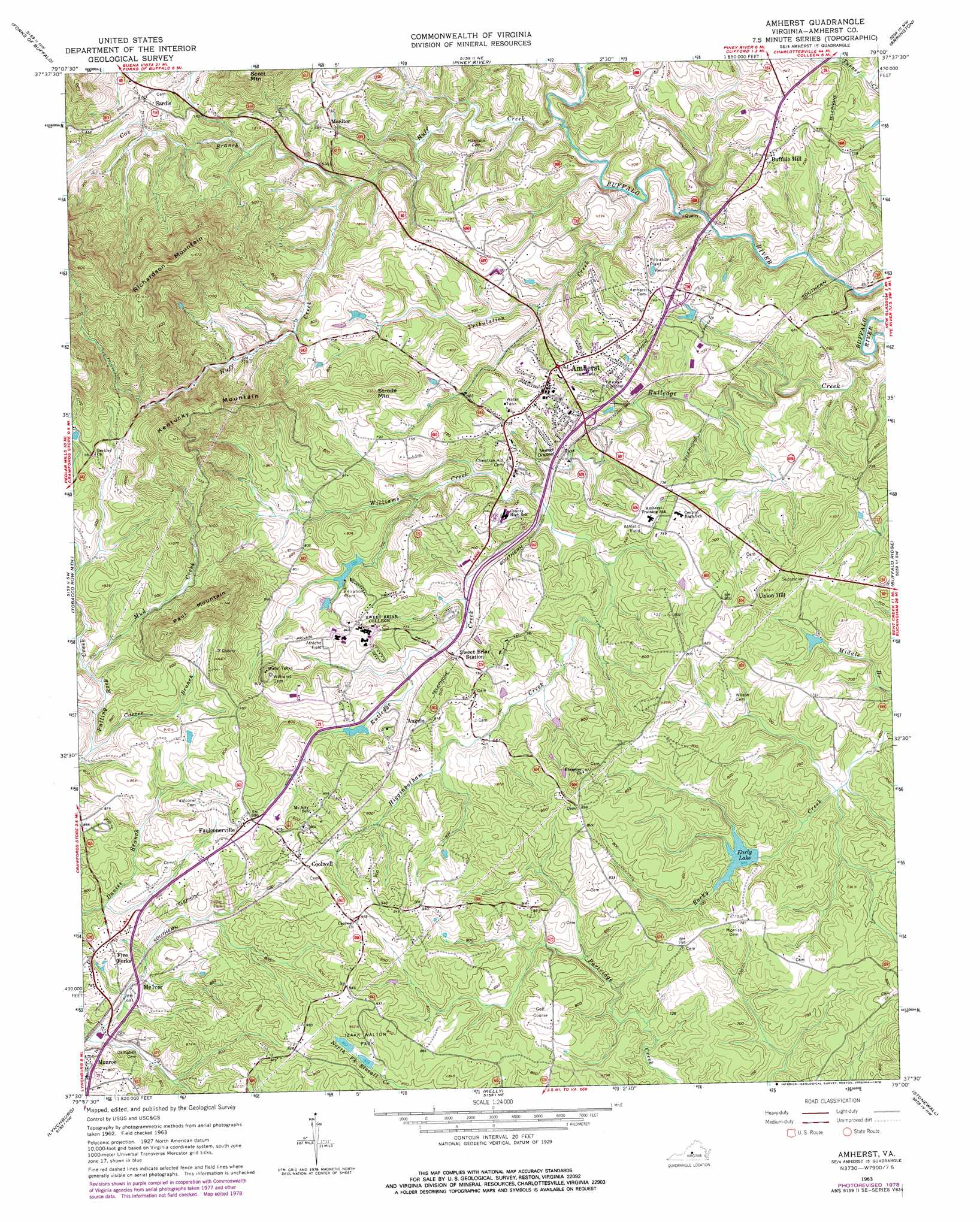
Amherst Topo Map Virginia
To zoom in, hover over the map of Amherst
USGS Topo Quad 37079e1 - 1:24,000 scale
| Topo Map Name: | Amherst |
| USGS Topo Quad ID: | 37079e1 |
| Print Size: | ca. 21 1/4" wide x 27" high |
| Southeast Coordinates: | 37.5° N latitude / 79° W longitude |
| Map Center Coordinates: | 37.5625° N latitude / 79.0625° W longitude |
| U.S. State: | VA |
| Filename: | o37079e1.jpg |
| Download Map JPG Image: | Amherst topo map 1:24,000 scale |
| Map Type: | Topographic |
| Topo Series: | 7.5´ |
| Map Scale: | 1:24,000 |
| Source of Map Images: | United States Geological Survey (USGS) |
| Alternate Map Versions: |
Amherst VA 1963, updated 1965 Download PDF Buy paper map Amherst VA 1963, updated 1971 Download PDF Buy paper map Amherst VA 1963, updated 1978 Download PDF Buy paper map Amherst VA 2010 Download PDF Buy paper map Amherst VA 2013 Download PDF Buy paper map Amherst VA 2016 Download PDF Buy paper map |
1:24,000 Topo Quads surrounding Amherst
Cornwall |
Montebello |
Massies Mill |
Horseshoe Mountain |
Lovingston |
Buena Vista |
Forks Of Buffalo |
Piney River |
Arrington |
Shipman |
Big Island |
Tobacco Row Mountain |
Amherst |
Buffalo Ridge |
Gladstone |
Boonsboro |
Lynchburg |
Kelly |
Stonewall |
Vera |
Forest |
City Farm |
Rustburg |
Concord |
Appomattox |
> Back to 37079e1 at 1:100,000 scale
> Back to 37078a1 at 1:250,000 scale
> Back to U.S. Topo Maps home
Amherst topo map: Gazetteer
Amherst: Dams
Early Dam elevation 200m 656′Izaak Walton Dam elevation 254m 833′
Sweetbriar College Lower Dam elevation 223m 731′
Sweetbriar College Upper Dam elevation 235m 770′
Amherst: Parks
Izaak Walton Park elevation 265m 869′Lake Tennis Courts elevation 239m 784′
Riding Hunt Course elevation 239m 784′
Amherst: Populated Places
Amherst elevation 232m 761′Angelo elevation 239m 784′
Buffalo Hill elevation 216m 708′
Coolwell elevation 260m 853′
Faulconerville elevation 269m 882′
Five Forks elevation 247m 810′
Monitor elevation 232m 761′
Sardis elevation 245m 803′
Sweet Briar Station elevation 222m 728′
Union Hill elevation 234m 767′
Amherst: Reservoirs
Early Lake elevation 200m 656′Izaak Walton Pond elevation 254m 833′
Sweetbriar Lake elevation 223m 731′
Amherst: Streams
Carter Branch elevation 239m 784′Cox Branch elevation 211m 692′
Higginbotham Creek elevation 192m 629′
Huff Creek elevation 166m 544′
Mud Creek elevation 234m 767′
Rutledge Creek elevation 157m 515′
Tribulation Creek elevation 168m 551′
Williams Creek elevation 189m 620′
Amherst: Summits
Kentucky Mountain elevation 389m 1276′Paul Mountain elevation 398m 1305′
Richardson Mountain elevation 492m 1614′
Strode Mountain elevation 284m 931′
Amherst digital topo map on disk
Buy this Amherst topo map showing relief, roads, GPS coordinates and other geographical features, as a high-resolution digital map file on DVD:
Western Virginia & Southern West Virginia
Buy digital topo maps: Western Virginia & Southern West Virginia