Big Island Topo Map Virginia
To zoom in, hover over the map of Big Island
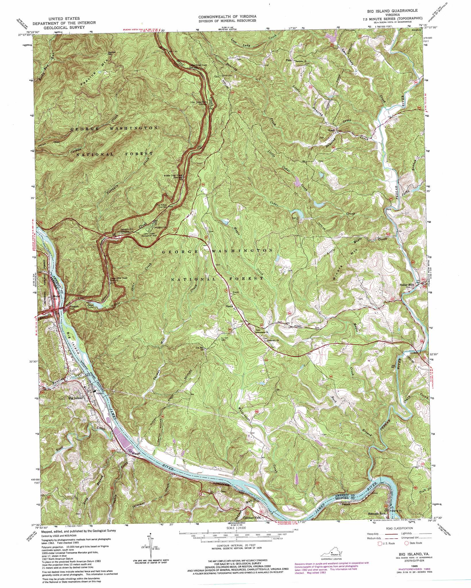
USGS Topo Quad 37079e3 - 1:24,000 scale
| Topo Map Name: | Big Island |
| USGS Topo Quad ID: | 37079e3 |
| Print Size: | ca. 21 1/4" wide x 27" high |
| Southeast Coordinates: | 37.5° N latitude / 79.25° W longitude |
| Map Center Coordinates: | 37.5625° N latitude / 79.3125° W longitude |
| U.S. State: | VA |
| Filename: | o37079e3.jpg |
| Download Map JPG Image: | Big Island topo map 1:24,000 scale |
| Map Type: | Topographic |
| Topo Series: | 7.5´ |
| Map Scale: | 1:24,000 |
| Source of Map Images: | United States Geological Survey (USGS) |
| Alternate Map Versions: |
Big Island VA 1965, updated 1967 Download PDF Buy paper map Big Island VA 1965, updated 1984 Download PDF Buy paper map Big Island VA 1965, updated 1984 Download PDF Buy paper map Big Island VA 1999, updated 2001 Download PDF Buy paper map Big Island VA 2011 Download PDF Buy paper map Big Island VA 2013 Download PDF Buy paper map Big Island VA 2016 Download PDF Buy paper map |
| FStopo: | US Forest Service topo Big Island is available: Download FStopo PDF Download FStopo TIF |
1:24,000 Topo Quads surrounding Big Island
Collierstown |
Lexington |
Cornwall |
Montebello |
Massies Mill |
Natural Bridge |
Glasgow |
Buena Vista |
Forks Of Buffalo |
Piney River |
Arnold Valley |
Snowden |
Big Island |
Tobacco Row Mountain |
Amherst |
Peaks Of Otter |
Sedalia |
Boonsboro |
Lynchburg |
Kelly |
Bedford |
Goode |
Forest |
City Farm |
Rustburg |
> Back to 37079e1 at 1:100,000 scale
> Back to 37078a1 at 1:250,000 scale
> Back to U.S. Topo Maps home
Big Island topo map: Gazetteer
Big Island: Dams
Bedford Municipal Lake elevation 191m 626′Big Island Dam elevation 183m 600′
Burruss Dam elevation 258m 846′
Colemans Fall Dam elevation 171m 561′
Holcomb Rock Dam elevation 170m 557′
Otter Lake Dam elevation 198m 649′
Big Island: Gaps
Peavine Gap elevation 563m 1847′Big Island: Islands
Big Island elevation 189m 620′Big Island: Parks
Otter Creek Recreation Area elevation 242m 793′Big Island: Populated Places
Big Island elevation 223m 731′Coleman Falls elevation 208m 682′
Major elevation 190m 623′
Naola elevation 290m 951′
Pearch elevation 185m 606′
Pedlar elevation 181m 593′
Pedlar Mills elevation 209m 685′
Pera elevation 326m 1069′
Waugh elevation 193m 633′
Big Island: Reservoirs
Big Island Reservoir elevation 183m 600′Colemans Fall Reservoir elevation 171m 561′
Otter Lake elevation 198m 649′
Big Island: Ridges
Shewey Ridge elevation 501m 1643′Big Island: Streams
Battery Creek elevation 183m 600′Buck Branch elevation 182m 597′
Cabin Creek elevation 179m 587′
Cedar Creek elevation 213m 698′
Clark Creek elevation 193m 633′
Dancing Creek elevation 219m 718′
Horsley Creek elevation 206m 675′
Hunting Creek elevation 187m 613′
Indian Run elevation 181m 593′
Jacks Branch elevation 271m 889′
Little Cedar Creek elevation 231m 757′
Little Dancing Creek elevation 223m 731′
Little Maple Creek elevation 211m 692′
Little Otter Creek elevation 199m 652′
Long Branch elevation 183m 600′
Love Lady Creek elevation 224m 734′
Maple Creek elevation 180m 590′
Otter Creek elevation 189m 620′
Pedlar River elevation 174m 570′
Peters Creek elevation 187m 613′
Reed Creek elevation 183m 600′
Skimmer Creek elevation 177m 580′
Terrapin Creek elevation 224m 734′
Thomas Mill Creek elevation 177m 580′
Wilderness Creek elevation 172m 564′
Big Island: Summits
Hamilton Knob elevation 319m 1046′Miners Mountain elevation 383m 1256′
Peavine Mountain elevation 599m 1965′
Big Island: Trails
Cashaw Creek Trail elevation 380m 1246′Big Island: Valleys
Grants Hollow elevation 322m 1056′Harris Hollow elevation 209m 685′
Big Island digital topo map on disk
Buy this Big Island topo map showing relief, roads, GPS coordinates and other geographical features, as a high-resolution digital map file on DVD:
Western Virginia & Southern West Virginia
Buy digital topo maps: Western Virginia & Southern West Virginia