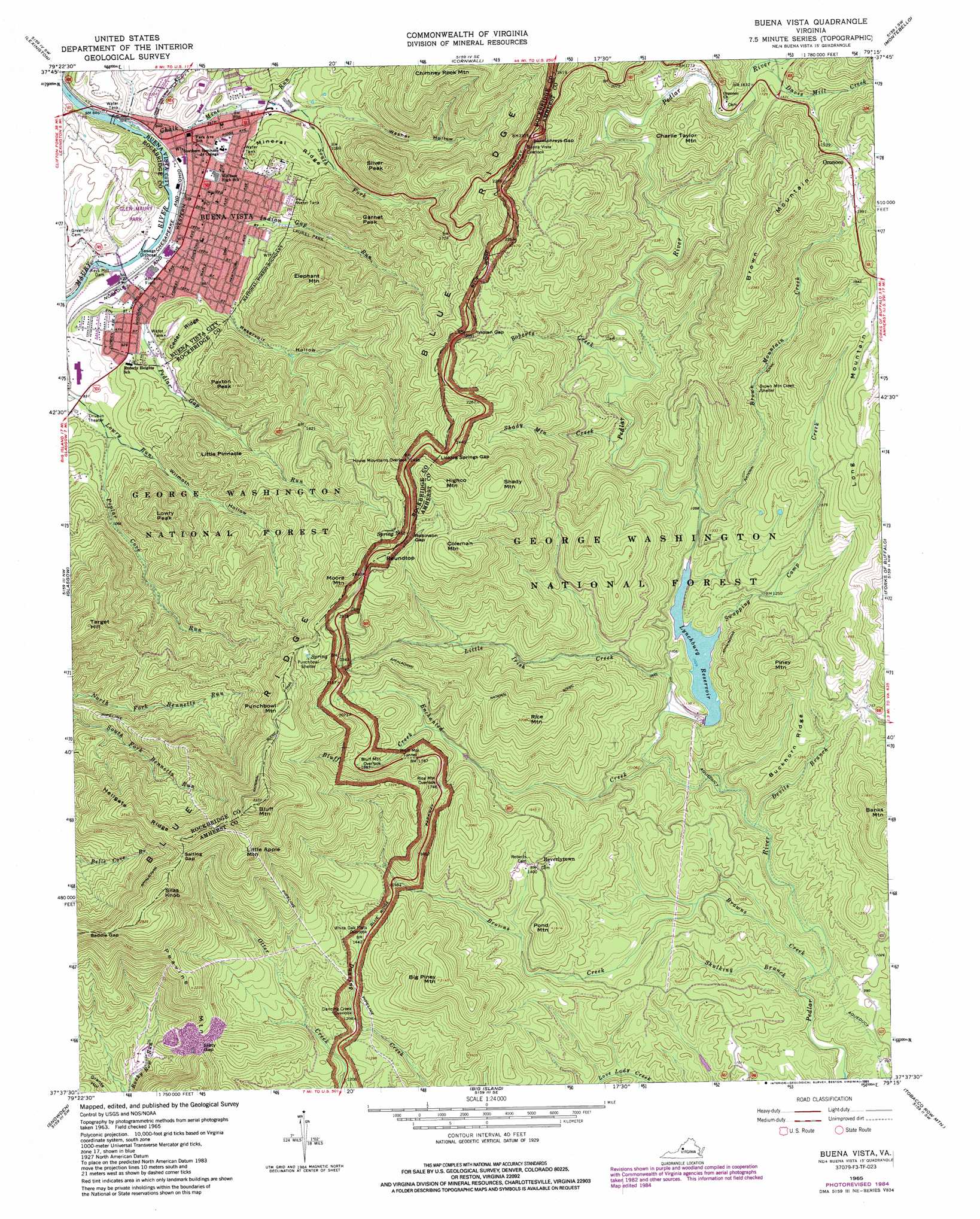
Buena Vista Topo Map Virginia
To zoom in, hover over the map of Buena Vista
USGS Topo Quad 37079f3 - 1:24,000 scale
| Topo Map Name: | Buena Vista |
| USGS Topo Quad ID: | 37079f3 |
| Print Size: | ca. 21 1/4" wide x 27" high |
| Southeast Coordinates: | 37.625° N latitude / 79.25° W longitude |
| Map Center Coordinates: | 37.6875° N latitude / 79.3125° W longitude |
| U.S. State: | VA |
| Filename: | o37079f3.jpg |
| Download Map JPG Image: | Buena Vista topo map 1:24,000 scale |
| Map Type: | Topographic |
| Topo Series: | 7.5´ |
| Map Scale: | 1:24,000 |
| Source of Map Images: | United States Geological Survey (USGS) |
| Alternate Map Versions: |
Buena Vista VA 1965, updated 1967 Download PDF Buy paper map Buena Vista VA 1965, updated 1971 Download PDF Buy paper map Buena Vista VA 1965, updated 1979 Download PDF Buy paper map Buena Vista VA 1965, updated 1979 Download PDF Buy paper map Buena Vista VA 1965, updated 1984 Download PDF Buy paper map Buena Vista VA 1965, updated 1991 Download PDF Buy paper map Buena Vista VA 1965, updated 1991 Download PDF Buy paper map Buena Vista VA 1977, updated 1983 Download PDF Buy paper map Buena Vista VA 1999, updated 2000 Download PDF Buy paper map Buena Vista VA 2011 Download PDF Buy paper map Buena Vista VA 2013 Download PDF Buy paper map Buena Vista VA 2016 Download PDF Buy paper map |
| FStopo: | US Forest Service topo Buena Vista is available: Download FStopo PDF Download FStopo TIF |
1:24,000 Topo Quads surrounding Buena Vista
Millboro |
Goshen |
Brownsburg |
Vesuvius |
Big Levels |
Collierstown |
Lexington |
Cornwall |
Montebello |
Massies Mill |
Natural Bridge |
Glasgow |
Buena Vista |
Forks Of Buffalo |
Piney River |
Arnold Valley |
Snowden |
Big Island |
Tobacco Row Mountain |
Amherst |
Peaks Of Otter |
Sedalia |
Boonsboro |
Lynchburg |
Kelly |
> Back to 37079e1 at 1:100,000 scale
> Back to 37078a1 at 1:250,000 scale
> Back to U.S. Topo Maps home
Buena Vista topo map: Gazetteer
Buena Vista: Dams
Keys Mill Dam elevation 257m 843′Pedlar River Dam elevation 313m 1026′
Pleasantview Hunt Club Dam elevation 299m 980′
Buena Vista: Falls
Panther Falls elevation 364m 1194′Buena Vista: Gaps
Humphreys Gap elevation 692m 2270′Indian Gap elevation 634m 2080′
Licklog Springs Gap elevation 757m 2483′
Robinson Gap elevation 770m 2526′
Saddle Gap elevation 789m 2588′
Saltlog Gap elevation 796m 2611′
Slaty Gap elevation 526m 1725′
Buena Vista: Parks
Glen Maury Park elevation 316m 1036′Laurel Park elevation 393m 1289′
Buena Vista: Pillars
Little Pinnacle elevation 548m 1797′Buena Vista: Populated Places
Beverlytown elevation 425m 1394′Buena Vista elevation 255m 836′
Enderly Heights elevation 276m 905′
Oronoco elevation 633m 2076′
Racy Acres elevation 346m 1135′
Buena Vista: Post Offices
Buena Vista Post Office elevation 256m 839′Buena Vista: Reservoirs
Lynchburg Reservoir elevation 313m 1026′Pleasantview Hunt Club Pond elevation 299m 980′
Spring Lake (historical) elevation 256m 839′
Buena Vista: Ridges
Buckhorn Ridge elevation 392m 1286′Cedar Ridge elevation 355m 1164′
Hellgate Ridge elevation 818m 2683′
Little Apple Mountain elevation 842m 2762′
Mineral Ridge elevation 353m 1158′
Buena Vista: Streams
Bluff Creek elevation 475m 1558′Brown Mountain Creek elevation 326m 1069′
Browns Creek elevation 254m 833′
Chalk Mine Run elevation 254m 833′
Davis Mill Creek elevation 498m 1633′
Devils Branch elevation 266m 872′
Enchanted Creek elevation 279m 915′
Indian Gap Run elevation 256m 839′
Lady Slipper Run elevation 498m 1633′
Little Irish Creek elevation 290m 951′
Noels Run elevation 255m 836′
Pedlar Gap Run elevation 258m 846′
Poplar Cove Run elevation 267m 875′
Roberts Creek elevation 383m 1256′
Shady Mountain Creek elevation 363m 1190′
Skulking Branch elevation 241m 790′
South Fork Chalk Run elevation 280m 918′
Swapping Camp Creek elevation 321m 1053′
Buena Vista: Summits
Big Piney Mountain elevation 649m 2129′Bluff Mountain elevation 1015m 3330′
Brown Mountain elevation 758m 2486′
Charlie Taylor Mountain elevation 653m 2142′
Coleman Mountain elevation 819m 2687′
Elephant Mountain elevation 631m 2070′
Garnet Peak elevation 606m 1988′
Highco Mountain elevation 868m 2847′
Long Mountain elevation 635m 2083′
Lowry Peak elevation 587m 1925′
Moore Mountain elevation 788m 2585′
Paxton Peak elevation 572m 1876′
Peavine Mountain elevation 673m 2208′
Piney Mountain elevation 575m 1886′
Pond Mountain elevation 491m 1610′
Punchbowl Mountain elevation 866m 2841′
Rice Mountain elevation 661m 2168′
Roundtop elevation 770m 2526′
Shady Mountain elevation 831m 2726′
Silas Knob elevation 904m 2965′
Silver Peak elevation 640m 2099′
Target Hill elevation 727m 2385′
Buena Vista: Tunnels
Bluff Mountain Tunnel elevation 587m 1925′Buena Vista: Valleys
Reservoir Hollow elevation 256m 839′Washer Hollow elevation 301m 987′
Wilmoth Hollow elevation 267m 875′
Buena Vista digital topo map on disk
Buy this Buena Vista topo map showing relief, roads, GPS coordinates and other geographical features, as a high-resolution digital map file on DVD:
Western Virginia & Southern West Virginia
Buy digital topo maps: Western Virginia & Southern West Virginia