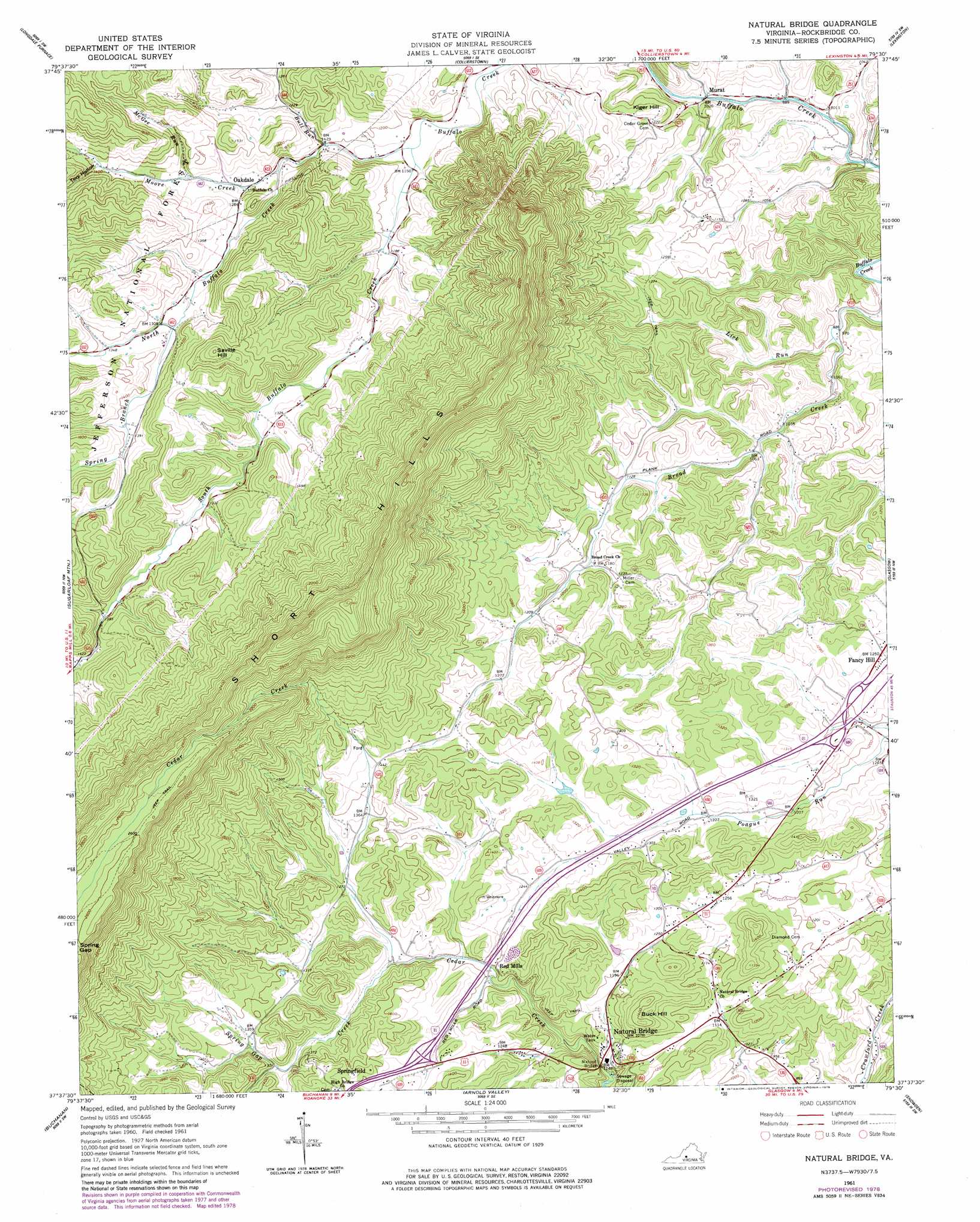
Natural Bridge Topo Map Virginia
To zoom in, hover over the map of Natural Bridge
USGS Topo Quad 37079f5 - 1:24,000 scale
| Topo Map Name: | Natural Bridge |
| USGS Topo Quad ID: | 37079f5 |
| Print Size: | ca. 21 1/4" wide x 27" high |
| Southeast Coordinates: | 37.625° N latitude / 79.5° W longitude |
| Map Center Coordinates: | 37.6875° N latitude / 79.5625° W longitude |
| U.S. State: | VA |
| Filename: | o37079f5.jpg |
| Download Map JPG Image: | Natural Bridge topo map 1:24,000 scale |
| Map Type: | Topographic |
| Topo Series: | 7.5´ |
| Map Scale: | 1:24,000 |
| Source of Map Images: | United States Geological Survey (USGS) |
| Alternate Map Versions: |
Natural Bridge VA 1961, updated 1963 Download PDF Buy paper map Natural Bridge VA 1961, updated 1978 Download PDF Buy paper map Natural Bridge VA 2011 Download PDF Buy paper map Natural Bridge VA 2013 Download PDF Buy paper map Natural Bridge VA 2016 Download PDF Buy paper map |
| FStopo: | US Forest Service topo Natural Bridge is available: Download FStopo PDF Download FStopo TIF |
1:24,000 Topo Quads surrounding Natural Bridge
Healing Springs |
Nimrod Hall |
Millboro |
Goshen |
Brownsburg |
Clifton Forge |
Longdale Furnace |
Collierstown |
Lexington |
Cornwall |
Eagle Rock |
Sugarloaf Mountain |
Natural Bridge |
Glasgow |
Buena Vista |
Salisbury |
Buchanan |
Arnold Valley |
Snowden |
Big Island |
Villamont |
Montvale |
Peaks Of Otter |
Sedalia |
Boonsboro |
> Back to 37079e1 at 1:100,000 scale
> Back to 37078a1 at 1:250,000 scale
> Back to U.S. Topo Maps home
Natural Bridge topo map: Gazetteer
Natural Bridge: Arches
Natural Bridge elevation 327m 1072′Natural Bridge: Bridges
Thomas S Dixon Bridge elevation 304m 997′Natural Bridge: Crossings
Interchange 175 elevation 395m 1295′Interchange 180 elevation 368m 1207′
Natural Bridge: Dams
Turner Dam elevation 378m 1240′Natural Bridge: Gaps
Spring Gap elevation 784m 2572′Natural Bridge: Populated Places
Fancy Hill elevation 388m 1272′Longwood (historical) elevation 376m 1233′
Murat elevation 308m 1010′
Natural Bridge elevation 328m 1076′
Oakdale elevation 375m 1230′
Red Mills elevation 366m 1200′
Springfield elevation 446m 1463′
Natural Bridge: Streams
Bull Run elevation 364m 1194′Lick Run elevation 302m 990′
McGee Run elevation 391m 1282′
Moore Creek elevation 365m 1197′
North Buffalo Creek elevation 351m 1151′
South Buffalo Creek elevation 351m 1151′
Spring Branch elevation 399m 1309′
Spring Gap Creek elevation 365m 1197′
Union Creek elevation 292m 958′
Natural Bridge: Summits
Buck Hill elevation 441m 1446′Kiger Hill elevation 392m 1286′
Saville Hill elevation 549m 1801′
Natural Bridge: Valleys
Dry Hollow elevation 308m 1010′Spring Valley elevation 305m 1000′
Tory Hollow elevation 423m 1387′
Natural Bridge digital topo map on disk
Buy this Natural Bridge topo map showing relief, roads, GPS coordinates and other geographical features, as a high-resolution digital map file on DVD:
Western Virginia & Southern West Virginia
Buy digital topo maps: Western Virginia & Southern West Virginia