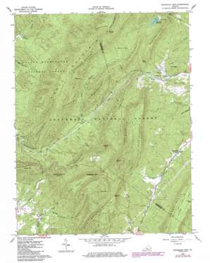
Sugarloaf Mountain Topo Map Virginia
To zoom in, hover over the map of Sugarloaf Mountain
USGS Topo Quad 37079f6 - 1:24,000 scale
| Topo Map Name: | Sugarloaf Mountain |
| USGS Topo Quad ID: | 37079f6 |
| Print Size: | ca. 21 1/4" wide x 27" high |
| Southeast Coordinates: | 37.625° N latitude / 79.625° W longitude |
| Map Center Coordinates: | 37.6875° N latitude / 79.6875° W longitude |
| U.S. State: | VA |
| Filename: | o37079f6.jpg |
| Download Map JPG Image: | Sugarloaf Mountain topo map 1:24,000 scale |
| Map Type: | Topographic |
| Topo Series: | 7.5´ |
| Map Scale: | 1:24,000 |
| Source of Map Images: | United States Geological Survey (USGS) |
| Alternate Map Versions: |
Sugarloaf Mtn VA 1962, updated 1963 Download PDF Buy paper map Sugarloaf Mtn VA 1962, updated 1978 Download PDF Buy paper map Sugarloaf Mtn VA 1962, updated 1986 Download PDF Buy paper map Sugarloaf Mtn VA 1962, updated 1986 Download PDF Buy paper map Sugarloaf Mountain VA 2011 Download PDF Buy paper map Sugarloaf Mountain VA 2013 Download PDF Buy paper map Sugarloaf Mountain VA 2016 Download PDF Buy paper map |
| FStopo: | US Forest Service topo Sugarloaf Mountain is available: Download FStopo PDF Download FStopo TIF |
1:24,000 Topo Quads surrounding Sugarloaf Mountain
> Back to 37079e1 at 1:100,000 scale
> Back to 37078a1 at 1:250,000 scale
> Back to U.S. Topo Maps home
Sugarloaf Mountain topo map: Gazetteer
Sugarloaf Mountain: Dams
Ad Cox Knob Dam elevation 585m 1919′Moores Creek Dam elevation 632m 2073′
Sugarloaf Mountain: Flats
Chestnut Flats elevation 921m 3021′Smith Flats elevation 703m 2306′
Sugarloaf Mountain: Gaps
Heartsblood elevation 811m 2660′Sugarloaf Mountain: Pillars
The Pinnacle elevation 855m 2805′Sugarloaf Mountain: Populated Places
Rapps Mill elevation 451m 1479′Sugarloaf Mountain: Reservoirs
Lexington Reservoir elevation 632m 2073′Lexington Reservoir elevation 594m 1948′
Sugarloaf Mountain: Ridges
Winding Ridge elevation 772m 2532′Sugarloaf Mountain: Streams
Dry Run elevation 375m 1230′Rocky Creek elevation 366m 1200′
Sloan Branch elevation 455m 1492′
Smith Branch elevation 455m 1492′
Sugarloaf Mountain: Summits
Ad Cox Knob elevation 1051m 3448′Bearwallow elevation 722m 2368′
Biggs Mountain elevation 872m 2860′
Brushy Mountain elevation 825m 2706′
Camp Mountain elevation 1004m 3293′
Garden Mountain elevation 929m 3047′
Grassy Mountain elevation 1019m 3343′
Gully Mountain elevation 1064m 3490′
Little Camp Mountain elevation 944m 3097′
Mays Mountain elevation 981m 3218′
Middle Mountain elevation 854m 2801′
Mount Pisgah elevation 563m 1847′
North Mountain elevation 1049m 3441′
Orebank Mountain elevation 1051m 3448′
Painter Mountain elevation 852m 2795′
Piny Knob elevation 724m 2375′
Prisehouse Mountain elevation 824m 2703′
Reidland elevation 559m 1833′
Sandbank Mountain elevation 977m 3205′
Sanford Hill elevation 539m 1768′
Scurff Mountain elevation 763m 2503′
Stamping Ground Mountain elevation 842m 2762′
Sugarloaf Mountain elevation 1106m 3628′
Wildcat Mountain elevation 908m 2979′
Sugarloaf Mountain: Valleys
Hickory Hollow elevation 357m 1171′Limestone Hollow elevation 382m 1253′
Turkeypen Hollow elevation 386m 1266′
Sugarloaf Mountain digital topo map on disk
Buy this Sugarloaf Mountain topo map showing relief, roads, GPS coordinates and other geographical features, as a high-resolution digital map file on DVD:
Western Virginia & Southern West Virginia
Buy digital topo maps: Western Virginia & Southern West Virginia


