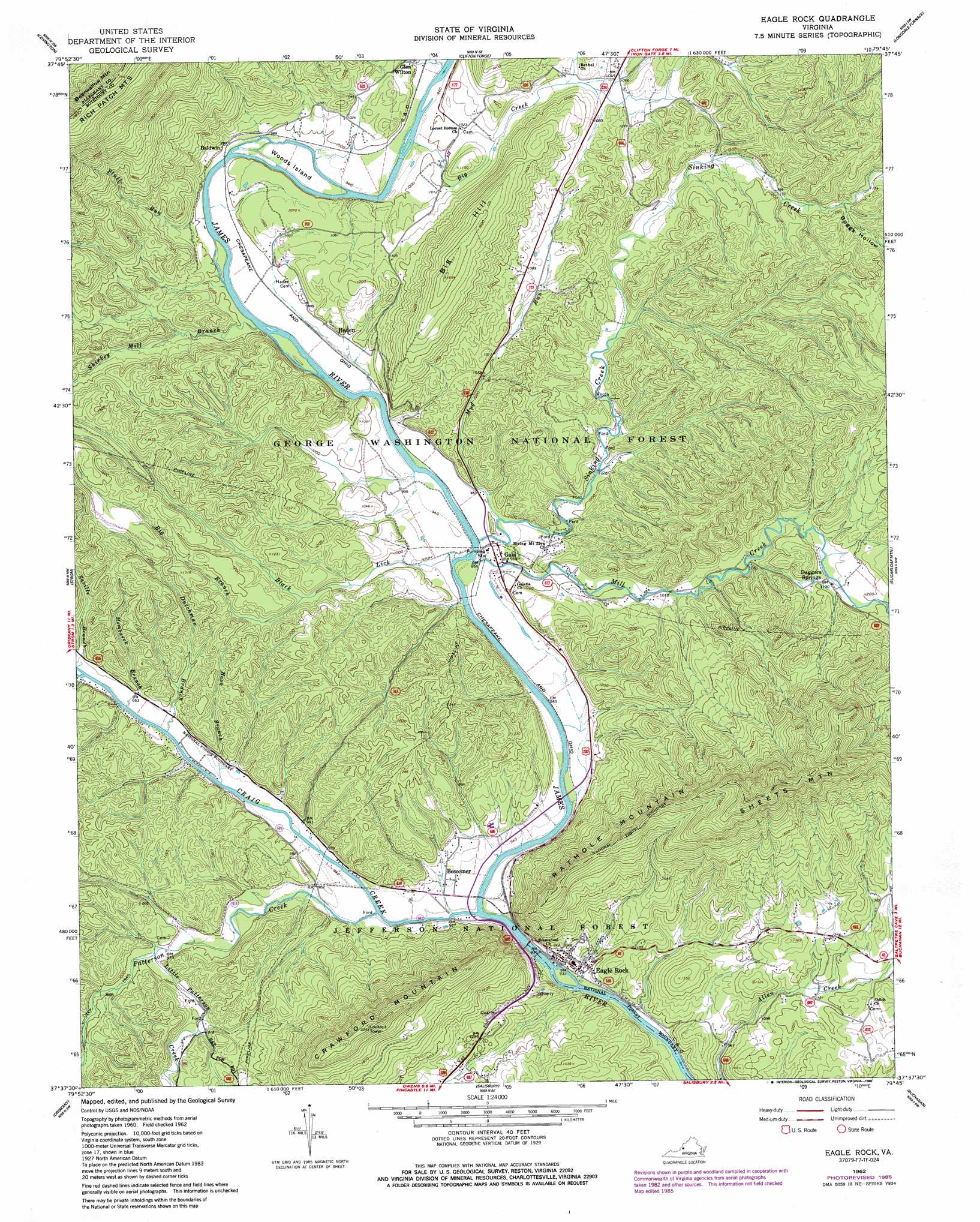
Eagle Rock Topo Map Virginia
To zoom in, hover over the map of Eagle Rock
USGS Topo Quad 37079f7 - 1:24,000 scale
| Topo Map Name: | Eagle Rock |
| USGS Topo Quad ID: | 37079f7 |
| Print Size: | ca. 21 1/4" wide x 27" high |
| Southeast Coordinates: | 37.625° N latitude / 79.75° W longitude |
| Map Center Coordinates: | 37.6875° N latitude / 79.8125° W longitude |
| U.S. State: | VA |
| Filename: | o37079f7.jpg |
| Download Map JPG Image: | Eagle Rock topo map 1:24,000 scale |
| Map Type: | Topographic |
| Topo Series: | 7.5´ |
| Map Scale: | 1:24,000 |
| Source of Map Images: | United States Geological Survey (USGS) |
| Alternate Map Versions: |
Eagle Rock VA 1962, updated 1963 Download PDF Buy paper map Eagle Rock VA 1962, updated 1986 Download PDF Buy paper map Eagle Rock VA 2011 Download PDF Buy paper map Eagle Rock VA 2013 Download PDF Buy paper map Eagle Rock VA 2016 Download PDF Buy paper map |
| FStopo: | US Forest Service topo Eagle Rock is available: Download FStopo PDF Download FStopo TIF |
1:24,000 Topo Quads surrounding Eagle Rock
Rucker Gap |
Falling Spring |
Healing Springs |
Nimrod Hall |
Millboro |
Callaghan |
Covington |
Clifton Forge |
Longdale Furnace |
Collierstown |
Jordan Mines |
Strom |
Eagle Rock |
Sugarloaf Mountain |
Natural Bridge |
New Castle |
Oriskany |
Salisbury |
Buchanan |
Arnold Valley |
Catawba |
Daleville |
Villamont |
Montvale |
Peaks Of Otter |
> Back to 37079e1 at 1:100,000 scale
> Back to 37078a1 at 1:250,000 scale
> Back to U.S. Topo Maps home
Eagle Rock topo map: Gazetteer
Eagle Rock: Airports
Big Hill Airport elevation 489m 1604′Eagle Rock: Bridges
Phoenix Bridge elevation 280m 918′Eagle Rock: Islands
Woods Island elevation 292m 958′Eagle Rock: Populated Places
Baldwin elevation 299m 980′Bessemer elevation 287m 941′
Daggers Springs elevation 353m 1158′
Eagle Rock elevation 296m 971′
Gala elevation 294m 964′
Haden elevation 301m 987′
Eagle Rock: Streams
Big Branch elevation 308m 1010′Big Creek elevation 297m 974′
Black Lick elevation 286m 938′
Craig Creek elevation 278m 912′
Dutchman Branch elevation 285m 935′
Hombarck Branch elevation 286m 938′
Hook Branch elevation 285m 935′
Little Patterson Creek elevation 295m 967′
Mill Creek elevation 285m 935′
Mud Run elevation 291m 954′
Patterson Creek elevation 279m 915′
Saville Branch elevation 289m 948′
Shirkey Mill Branch elevation 295m 967′
Sinking Creek elevation 287m 941′
Stull Run elevation 292m 958′
Eagle Rock: Summits
Big Hill elevation 512m 1679′Crawford Mountain elevation 683m 2240′
Rathole Mountain elevation 612m 2007′
Sheets Mountain elevation 809m 2654′
Eagle Rock: Valleys
Boggs Hollow elevation 350m 1148′Eagle Rock digital topo map on disk
Buy this Eagle Rock topo map showing relief, roads, GPS coordinates and other geographical features, as a high-resolution digital map file on DVD:
Western Virginia & Southern West Virginia
Buy digital topo maps: Western Virginia & Southern West Virginia