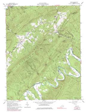
Strom Topo Map Virginia
To zoom in, hover over the map of Strom
USGS Topo Quad 37079f8 - 1:24,000 scale
| Topo Map Name: | Strom |
| USGS Topo Quad ID: | 37079f8 |
| Print Size: | ca. 21 1/4" wide x 27" high |
| Southeast Coordinates: | 37.625° N latitude / 79.875° W longitude |
| Map Center Coordinates: | 37.6875° N latitude / 79.9375° W longitude |
| U.S. State: | VA |
| Filename: | o37079f8.jpg |
| Download Map JPG Image: | Strom topo map 1:24,000 scale |
| Map Type: | Topographic |
| Topo Series: | 7.5´ |
| Map Scale: | 1:24,000 |
| Source of Map Images: | United States Geological Survey (USGS) |
| Alternate Map Versions: |
Strom VA 1962, updated 1963 Download PDF Buy paper map Strom VA 1962, updated 1976 Download PDF Buy paper map Strom VA 1962, updated 1979 Download PDF Buy paper map Strom VA 1962, updated 1984 Download PDF Buy paper map Strom VA 2011 Download PDF Buy paper map Strom VA 2013 Download PDF Buy paper map Strom VA 2016 Download PDF Buy paper map |
| FStopo: | US Forest Service topo Strom is available: Download FStopo PDF Download FStopo TIF |
1:24,000 Topo Quads surrounding Strom
> Back to 37079e1 at 1:100,000 scale
> Back to 37078a1 at 1:250,000 scale
> Back to U.S. Topo Maps home
Strom topo map: Gazetteer
Strom: Crossings
Hollow Ford elevation 296m 971′Strom: Gaps
Hays Gap elevation 663m 2175′Strom: Mines
Peanut Mine elevation 360m 1181′Ritchpatch Mine elevation 607m 1991′
Strom: Populated Places
Hipes elevation 319m 1046′Hooks Mill elevation 563m 1847′
Lignite elevation 485m 1591′
Parr elevation 313m 1026′
Rich Patch elevation 620m 2034′
Strom elevation 292m 958′
Surber elevation 328m 1076′
Strom: Streams
Biggs Run elevation 322m 1056′Crawford Branch elevation 292m 958′
Deisher Branch elevation 292m 958′
Finley Branch elevation 565m 1853′
Furnace Branch elevation 324m 1062′
Hipes Branch elevation 309m 1013′
Lemons Branch elevation 317m 1040′
Roaring Run elevation 290m 951′
Stony Run elevation 304m 997′
Swanson Branch elevation 330m 1082′
Wolf Branch elevation 292m 958′
Strom: Summits
Bald Knob elevation 995m 3264′Bearwallow Mountain elevation 887m 2910′
Carpenter Mountain elevation 820m 2690′
Deisher Mountain elevation 736m 2414′
Howard Knob elevation 711m 2332′
Iron Ore Knob elevation 643m 2109′
Johnson Mountain elevation 908m 2979′
Little Mountain elevation 1005m 3297′
Middle Mountain elevation 927m 3041′
Montgomery Knob elevation 1081m 3546′
Mud Run Mountain elevation 1067m 3500′
Pine Mountain elevation 1017m 3336′
Porter Mountain elevation 982m 3221′
Rich Patch Mountains elevation 1120m 3674′
Shoemaker Knob elevation 738m 2421′
Strom digital topo map on disk
Buy this Strom topo map showing relief, roads, GPS coordinates and other geographical features, as a high-resolution digital map file on DVD:
Western Virginia & Southern West Virginia
Buy digital topo maps: Western Virginia & Southern West Virginia


