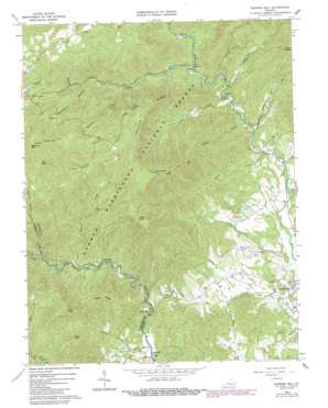
Massies Mill Topo Map Virginia
To zoom in, hover over the map of Massies Mill
USGS Topo Quad 37079g1 - 1:24,000 scale
| Topo Map Name: | Massies Mill |
| USGS Topo Quad ID: | 37079g1 |
| Print Size: | ca. 21 1/4" wide x 27" high |
| Southeast Coordinates: | 37.75° N latitude / 79° W longitude |
| Map Center Coordinates: | 37.8125° N latitude / 79.0625° W longitude |
| U.S. State: | VA |
| Filename: | o37079g1.jpg |
| Download Map JPG Image: | Massies Mill topo map 1:24,000 scale |
| Map Type: | Topographic |
| Topo Series: | 7.5´ |
| Map Scale: | 1:24,000 |
| Source of Map Images: | United States Geological Survey (USGS) |
| Alternate Map Versions: |
Massies Mill VA 1965, updated 1967 Download PDF Buy paper map Massies Mill VA 1965, updated 1984 Download PDF Buy paper map Massies Mill VA 1999, updated 2000 Download PDF Buy paper map Massies Mill VA 2011 Download PDF Buy paper map Massies Mill VA 2013 Download PDF Buy paper map Massies Mill VA 2016 Download PDF Buy paper map |
| FStopo: | US Forest Service topo Massies Mill is available: Download FStopo PDF Download FStopo TIF |
1:24,000 Topo Quads surrounding Massies Mill
> Back to 37079e1 at 1:100,000 scale
> Back to 37078a1 at 1:250,000 scale
> Back to U.S. Topo Maps home
Massies Mill topo map: Gazetteer
Massies Mill: Falls
Crabtree Falls elevation 818m 2683′Massies Mill: Populated Places
Alhambra elevation 402m 1318′Massies Mill elevation 214m 702′
Nash elevation 347m 1138′
Tyro elevation 255m 836′
Woodson elevation 263m 862′
Massies Mill: Ridges
Coghill Ridge elevation 783m 2568′Pinnacle Ridge elevation 922m 3024′
Massies Mill: Streams
Campbell Creek elevation 308m 1010′Coxs Creek elevation 296m 971′
Crabtree Creek elevation 483m 1584′
Crawleys Creek elevation 267m 875′
Cripple Creek elevation 278m 912′
Cub Creek elevation 241m 790′
Harpers Creek elevation 276m 905′
Louisa Spring Branch elevation 580m 1902′
Maidenhead Branch elevation 571m 1873′
Meadow Creek elevation 486m 1594′
Muddy Branch elevation 236m 774′
North Fork Piney River elevation 468m 1535′
North Fork Tye River elevation 346m 1135′
Rocky Run elevation 212m 695′
Shoe Creek elevation 415m 1361′
Silver Creek elevation 267m 875′
South Fork Piney River elevation 468m 1535′
South Fork Tye River elevation 346m 1135′
Massies Mill: Summits
Fork Mountain elevation 989m 3244′Little Friar elevation 880m 2887′
Little Priest elevation 1133m 3717′
Maintop Mountain elevation 1232m 4041′
Spy Rock elevation 1128m 3700′
The Friar elevation 1007m 3303′
The Priest elevation 1227m 4025′
Massies Mill: Valleys
Cash Hollow elevation 825m 2706′Little Hollow elevation 503m 1650′
Massies Mill digital topo map on disk
Buy this Massies Mill topo map showing relief, roads, GPS coordinates and other geographical features, as a high-resolution digital map file on DVD:
Western Virginia & Southern West Virginia
Buy digital topo maps: Western Virginia & Southern West Virginia


