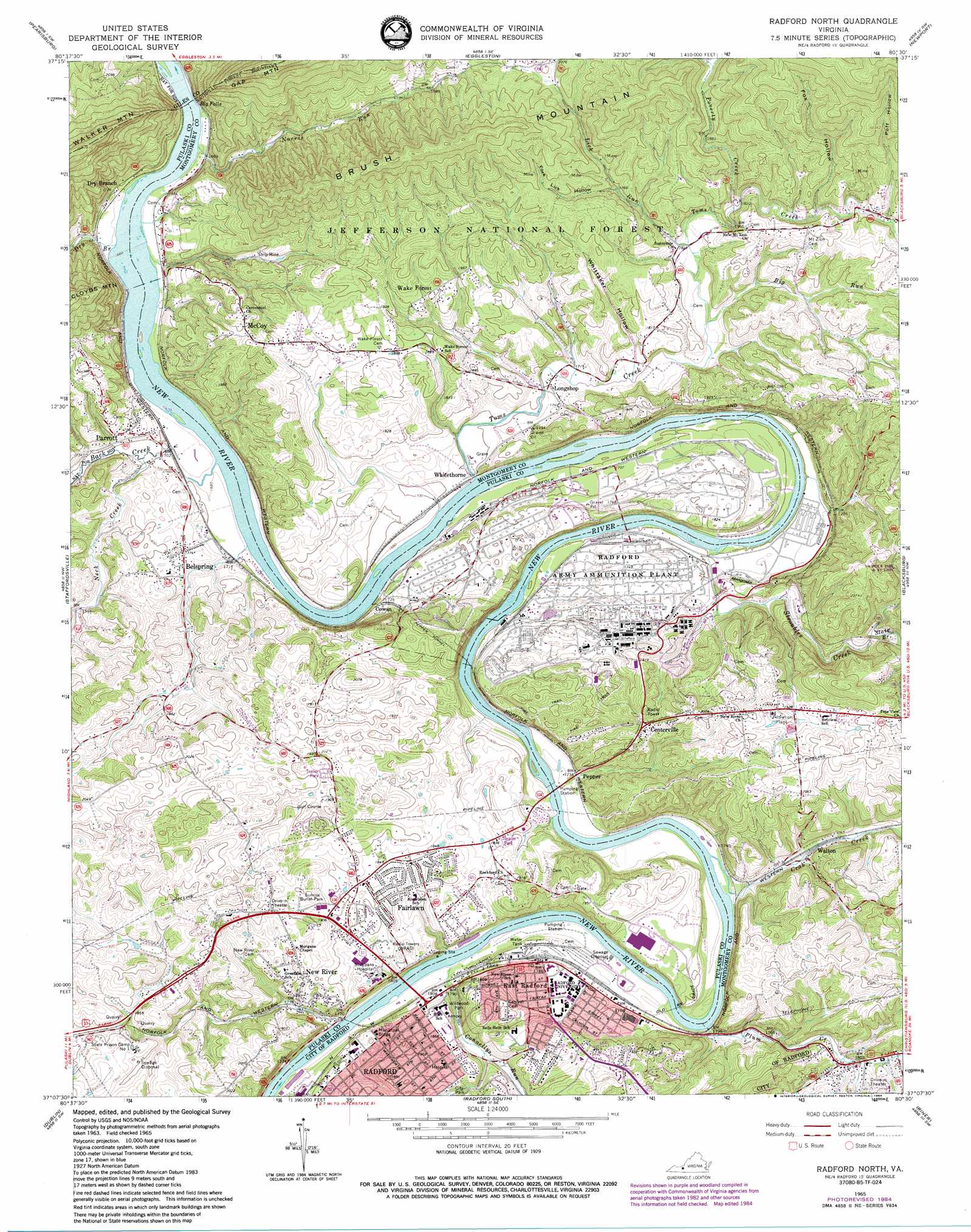
Radford North Topo Map Virginia
To zoom in, hover over the map of Radford North
USGS Topo Quad 37080b5 - 1:24,000 scale
| Topo Map Name: | Radford North |
| USGS Topo Quad ID: | 37080b5 |
| Print Size: | ca. 21 1/4" wide x 27" high |
| Southeast Coordinates: | 37.125° N latitude / 80.5° W longitude |
| Map Center Coordinates: | 37.1875° N latitude / 80.5625° W longitude |
| U.S. State: | VA |
| Filename: | o37080b5.jpg |
| Download Map JPG Image: | Radford North topo map 1:24,000 scale |
| Map Type: | Topographic |
| Topo Series: | 7.5´ |
| Map Scale: | 1:24,000 |
| Source of Map Images: | United States Geological Survey (USGS) |
| Alternate Map Versions: |
Radford North VA 1965, updated 1966 Download PDF Buy paper map Radford North VA 1965, updated 1971 Download PDF Buy paper map Radford North VA 1965, updated 1978 Download PDF Buy paper map Radford North VA 1965, updated 1984 Download PDF Buy paper map Radford North VA 1998, updated 2000 Download PDF Buy paper map Radford North VA 2011 Download PDF Buy paper map Radford North VA 2013 Download PDF Buy paper map Radford North VA 2016 Download PDF Buy paper map |
| FStopo: | US Forest Service topo Radford North is available: Download FStopo PDF Download FStopo TIF |
1:24,000 Topo Quads surrounding Radford North
Peterstown |
Lindside |
Interior |
Waiteville |
Craig Springs |
Narrows |
Pearisburg |
Eggleston |
Newport |
Mcdonalds Mill |
White Gate |
Staffordsville |
Radford North |
Blacksburg |
Ironto |
Pulaski |
Dublin |
Radford South |
Riner |
Pilot |
Fosters Falls |
Hiwassee |
Indian Valley |
Alum Ridge |
Floyd |
> Back to 37080a1 at 1:100,000 scale
> Back to 37080a1 at 1:250,000 scale
> Back to U.S. Topo Maps home
Radford North topo map: Gazetteer
Radford North: Airports
Radford AAP Heliport elevation 523m 1715′Radford North: Areas
Horseshoe elevation 523m 1715′Radford North: Bridges
Southwest Virginia Memorial Bridge elevation 518m 1699′Radford North: Crossings
Peppers Ferry (historical) elevation 518m 1699′Radford North: Falls
Big Falls elevation 500m 1640′Radford North: Parks
David Bissett Park elevation 527m 1729′Wildwood Park elevation 542m 1778′
Radford North: Populated Places
Belle Heth elevation 589m 1932′Belspring elevation 542m 1778′
Brooklyn elevation 578m 1896′
Cedar Valley elevation 600m 1968′
Centerville elevation 600m 1968′
Churchwood (historical) elevation 520m 1706′
College Park elevation 587m 1925′
Cowan elevation 526m 1725′
Dry Branch elevation 525m 1722′
East Radford elevation 562m 1843′
Fairlawn elevation 585m 1919′
Goodwins Ferry (historical) elevation 512m 1679′
Grandview Heights elevation 574m 1883′
Haven Heights elevation 603m 1978′
Hickory Hills elevation 581m 1906′
McCoy elevation 608m 1994′
Mill Village elevation 553m 1814′
Monroe Terrace elevation 615m 2017′
New River elevation 591m 1938′
Parrott elevation 544m 1784′
Pepper elevation 531m 1742′
Radford elevation 567m 1860′
Wake Forest elevation 582m 1909′
Walton elevation 534m 1751′
Whitethorne elevation 519m 1702′
Radford North: Post Offices
Radford Post Office elevation 559m 1833′Radford North: Streams
Back Creek elevation 508m 1666′Big Run elevation 530m 1738′
Connellys Run elevation 524m 1719′
Crab Creek elevation 518m 1699′
Dry Branch elevation 504m 1653′
Lick Run elevation 535m 1755′
Neck Creek elevation 513m 1683′
Norris Run elevation 503m 1650′
Plum Creek elevation 523m 1715′
Poverty Creek elevation 545m 1788′
Slate Branch elevation 546m 1791′
Straley Branch elevation 592m 1942′
Stroubles Creek elevation 513m 1683′
Toms Creek elevation 512m 1679′
Radford North: Tunnels
Milletts Tunnel elevation 586m 1922′Pepper Tunnel elevation 619m 2030′
Radford North: Valleys
Fork Lick Hollow elevation 567m 1860′Fox Hollow elevation 560m 1837′
Poff Hollow elevation 572m 1876′
Whittaker Hollow elevation 523m 1715′
Radford North digital topo map on disk
Buy this Radford North topo map showing relief, roads, GPS coordinates and other geographical features, as a high-resolution digital map file on DVD:
Western Virginia & Southern West Virginia
Buy digital topo maps: Western Virginia & Southern West Virginia