White Gate Topo Map Virginia
To zoom in, hover over the map of White Gate
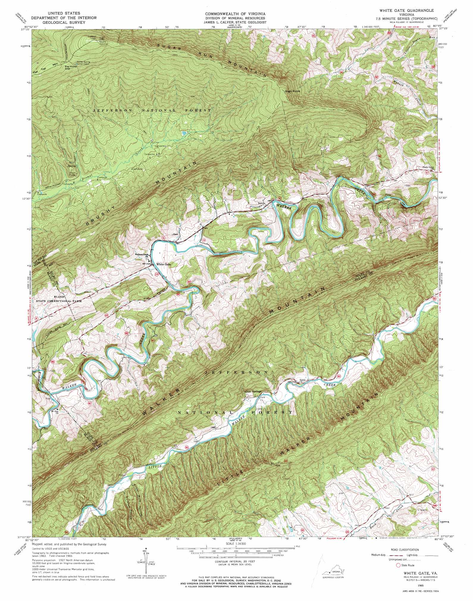
USGS Topo Quad 37080b7 - 1:24,000 scale
| Topo Map Name: | White Gate |
| USGS Topo Quad ID: | 37080b7 |
| Print Size: | ca. 21 1/4" wide x 27" high |
| Southeast Coordinates: | 37.125° N latitude / 80.75° W longitude |
| Map Center Coordinates: | 37.1875° N latitude / 80.8125° W longitude |
| U.S. State: | VA |
| Filename: | o37080b7.jpg |
| Download Map JPG Image: | White Gate topo map 1:24,000 scale |
| Map Type: | Topographic |
| Topo Series: | 7.5´ |
| Map Scale: | 1:24,000 |
| Source of Map Images: | United States Geological Survey (USGS) |
| Alternate Map Versions: |
White Gate VA 1965, updated 1967 Download PDF Buy paper map White Gate VA 1965, updated 1967 Download PDF Buy paper map White Gate VA 2011 Download PDF Buy paper map White Gate VA 2013 Download PDF Buy paper map White Gate VA 2016 Download PDF Buy paper map |
| FStopo: | US Forest Service topo White Gate is available: Download FStopo PDF Download FStopo TIF |
1:24,000 Topo Quads surrounding White Gate
Athens |
Lerona |
Peterstown |
Lindside |
Interior |
Princeton |
Oakvale |
Narrows |
Pearisburg |
Eggleston |
Rocky Gap |
Mechanicsburg |
White Gate |
Staffordsville |
Radford North |
Bland |
Long Spur |
Pulaski |
Dublin |
Radford South |
Wytheville |
Max Meadows |
Fosters Falls |
Hiwassee |
Indian Valley |
> Back to 37080a1 at 1:100,000 scale
> Back to 37080a1 at 1:250,000 scale
> Back to U.S. Topo Maps home
White Gate topo map: Gazetteer
White Gate: Cliffs
High Point elevation 1175m 3854′White Gate: Dams
Bland County Farm Dam elevation 645m 2116′White Gate: Gaps
Big Horse Gap elevation 1149m 3769′White Gate: Populated Places
Alum Springs elevation 583m 1912′Little Creek elevation 658m 2158′
Sassin (historical) elevation 586m 1922′
White Gate: Streams
Kimberling Creek elevation 602m 1975′White Gate: Summits
Flat Top Mountain elevation 1179m 3868′Sugar Run Mountain elevation 1238m 4061′
White Gate: Trails
Ripple Trail elevation 879m 2883′White Gate: Valleys
Flat Hollow elevation 583m 1912′Silver Mine Hollow elevation 603m 1978′
Sulphur Hollow elevation 602m 1975′
White Gate digital topo map on disk
Buy this White Gate topo map showing relief, roads, GPS coordinates and other geographical features, as a high-resolution digital map file on DVD:
Western Virginia & Southern West Virginia
Buy digital topo maps: Western Virginia & Southern West Virginia