Glenvar Topo Map Virginia
To zoom in, hover over the map of Glenvar
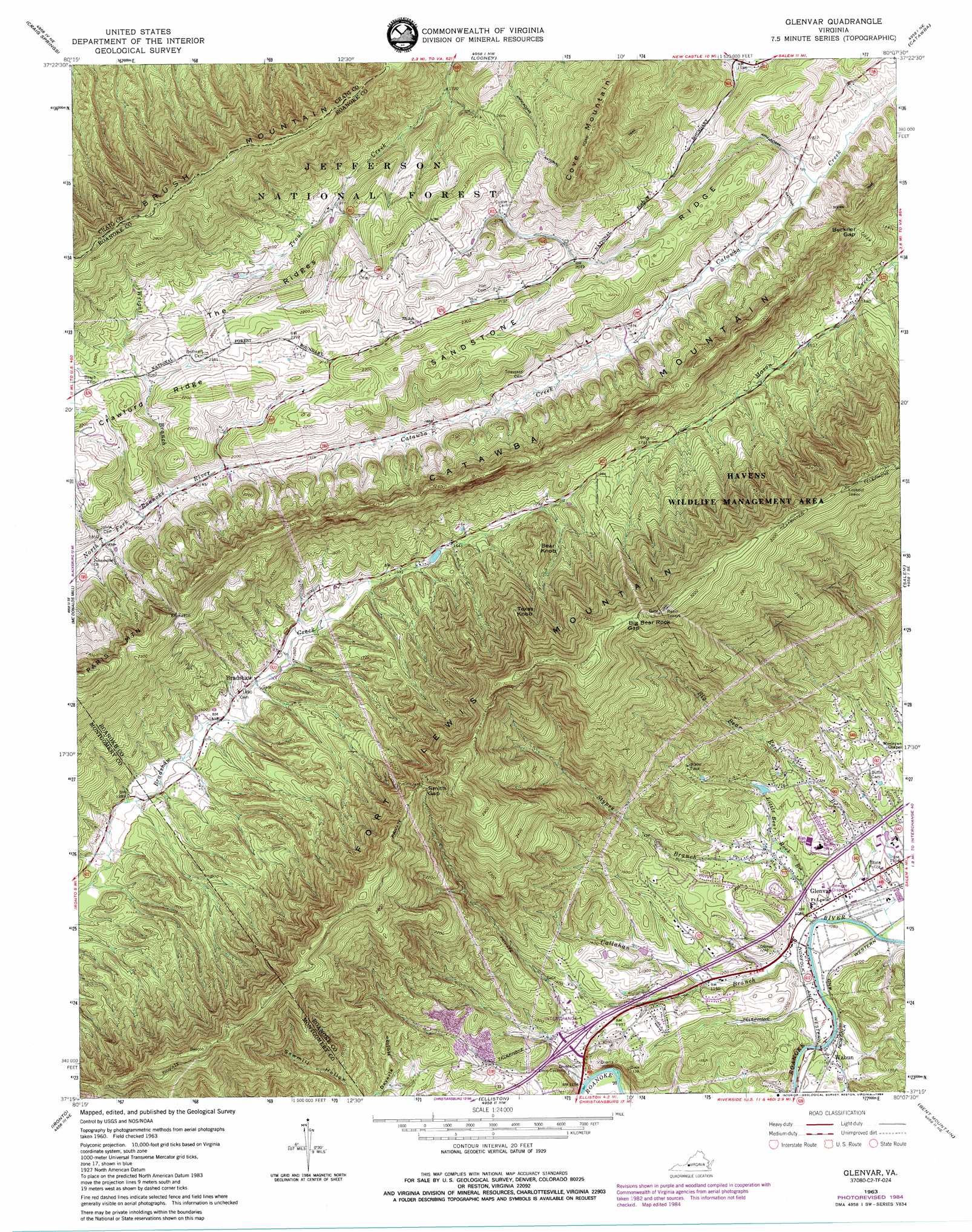
USGS Topo Quad 37080c2 - 1:24,000 scale
| Topo Map Name: | Glenvar |
| USGS Topo Quad ID: | 37080c2 |
| Print Size: | ca. 21 1/4" wide x 27" high |
| Southeast Coordinates: | 37.25° N latitude / 80.125° W longitude |
| Map Center Coordinates: | 37.3125° N latitude / 80.1875° W longitude |
| U.S. State: | VA |
| Filename: | o37080c2.jpg |
| Download Map JPG Image: | Glenvar topo map 1:24,000 scale |
| Map Type: | Topographic |
| Topo Series: | 7.5´ |
| Map Scale: | 1:24,000 |
| Source of Map Images: | United States Geological Survey (USGS) |
| Alternate Map Versions: |
Glenvar VA 1963, updated 1965 Download PDF Buy paper map Glenvar VA 1963, updated 1973 Download PDF Buy paper map Glenvar VA 1963, updated 1983 Download PDF Buy paper map Glenvar VA 1963, updated 1984 Download PDF Buy paper map Glenvar VA 1977, updated 1983 Download PDF Buy paper map Glenvar VA 2011 Download PDF Buy paper map Glenvar VA 2013 Download PDF Buy paper map Glenvar VA 2016 Download PDF Buy paper map |
| FStopo: | US Forest Service topo Glenvar is available: Download FStopo PDF Download FStopo TIF |
1:24,000 Topo Quads surrounding Glenvar
Gap Mills |
Paint Bank |
Potts Creek |
New Castle |
Oriskany |
Waiteville |
Craig Springs |
Looney |
Catawba |
Daleville |
Newport |
Mcdonalds Mill |
Glenvar |
Salem |
Roanoke |
Blacksburg |
Ironto |
Elliston |
Bent Mountain |
Garden City |
Riner |
Pilot |
Check |
Callaway |
Boones Mill |
> Back to 37080a1 at 1:100,000 scale
> Back to 37080a1 at 1:250,000 scale
> Back to U.S. Topo Maps home
Glenvar topo map: Gazetteer
Glenvar: Airports
State Police Division Six Heliport elevation 341m 1118′Glenvar: Crossings
Bend Ford elevation 329m 1079′Interchange 132 elevation 378m 1240′
Glenvar: Gaps
Beckner Gap elevation 601m 1971′Big Bear Rock Gap elevation 936m 3070′
Smith Gap elevation 753m 2470′
Glenvar: Populated Places
Andrew Lewis elevation 353m 1158′Bear Rock elevation 367m 1204′
Bradshaw elevation 451m 1479′
Cherokee Hills elevation 395m 1295′
Chimney Hill Estates elevation 391m 1282′
Glen Forest elevation 378m 1240′
Glenvar elevation 332m 1089′
Glenvar East elevation 378m 1240′
Glenvar Heights elevation 376m 1233′
Grandview Gardens elevation 371m 1217′
Jones elevation 356m 1167′
Moomaw (historical) elevation 553m 1814′
Talking Leaves elevation 476m 1561′
West Salem Forest elevation 332m 1089′
Westward Lake Estates elevation 430m 1410′
Westward Lakes elevation 413m 1354′
Glenvar: Ridges
Sandstone Ridge elevation 690m 2263′The Ridges elevation 708m 2322′
Glenvar: Streams
Big Bear Rock Branch elevation 322m 1056′Callahan Branch elevation 325m 1066′
Dry Branch elevation 331m 1085′
Little Bear Rock Branch elevation 325m 1066′
Stypes Branch elevation 339m 1112′
Wright Branch elevation 569m 1866′
Glenvar: Summits
Bear Knob elevation 675m 2214′Brush Mountain elevation 946m 3103′
Cove Mountain elevation 922m 3024′
Fort Lewis Mountain elevation 982m 3221′
Texas Knob elevation 793m 2601′
Glenvar: Trails
Dragon Tooth Trail elevation 679m 2227′Glenvar: Valleys
Deyerle Hollow elevation 407m 1335′Glenvar digital topo map on disk
Buy this Glenvar topo map showing relief, roads, GPS coordinates and other geographical features, as a high-resolution digital map file on DVD:
Western Virginia & Southern West Virginia
Buy digital topo maps: Western Virginia & Southern West Virginia