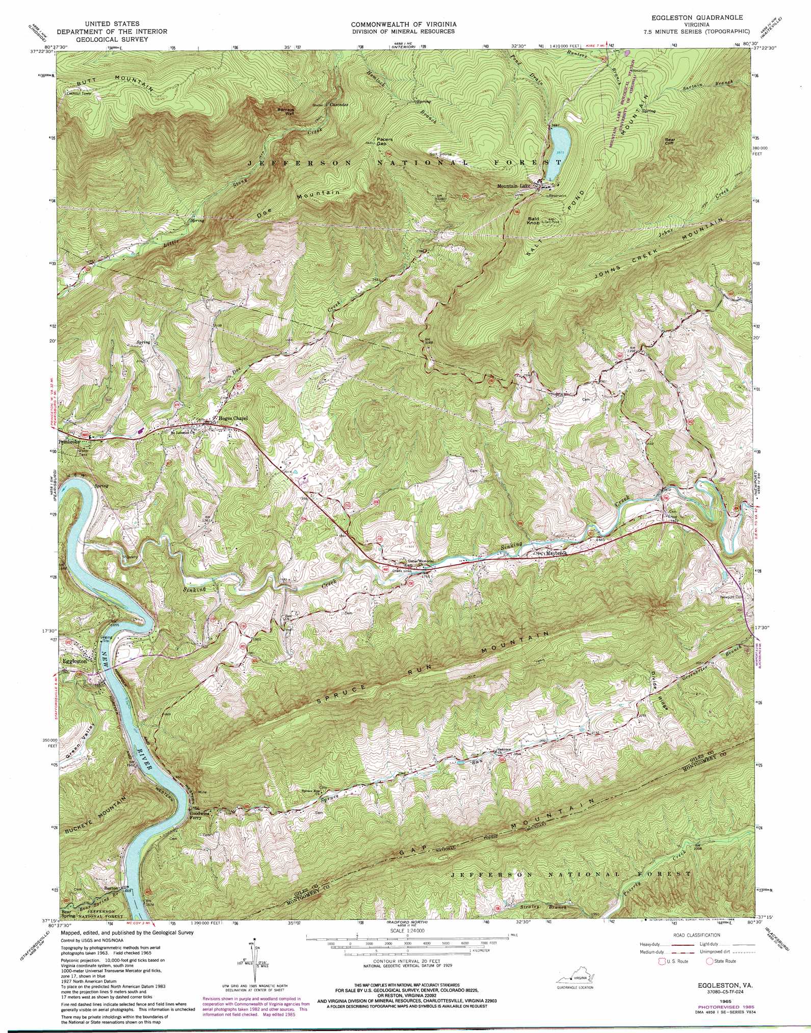
Eggleston Topo Map Virginia
To zoom in, hover over the map of Eggleston
USGS Topo Quad 37080c5 - 1:24,000 scale
| Topo Map Name: | Eggleston |
| USGS Topo Quad ID: | 37080c5 |
| Print Size: | ca. 21 1/4" wide x 27" high |
| Southeast Coordinates: | 37.25° N latitude / 80.5° W longitude |
| Map Center Coordinates: | 37.3125° N latitude / 80.5625° W longitude |
| U.S. State: | VA |
| Filename: | o37080c5.jpg |
| Download Map JPG Image: | Eggleston topo map 1:24,000 scale |
| Map Type: | Topographic |
| Topo Series: | 7.5´ |
| Map Scale: | 1:24,000 |
| Source of Map Images: | United States Geological Survey (USGS) |
| Alternate Map Versions: |
Eggleston VA 1965, updated 1967 Download PDF Buy paper map Eggleston VA 1965, updated 1978 Download PDF Buy paper map Eggleston VA 1965, updated 1985 Download PDF Buy paper map Eggleston VA 1998, updated 2000 Download PDF Buy paper map Eggleston VA 2011 Download PDF Buy paper map Eggleston VA 2013 Download PDF Buy paper map Eggleston VA 2016 Download PDF Buy paper map |
| FStopo: | US Forest Service topo Eggleston is available: Download FStopo PDF Download FStopo TIF |
1:24,000 Topo Quads surrounding Eggleston
Forest Hill |
Greenville |
Union |
Gap Mills |
Paint Bank |
Peterstown |
Lindside |
Interior |
Waiteville |
Craig Springs |
Narrows |
Pearisburg |
Eggleston |
Newport |
Mcdonalds Mill |
White Gate |
Staffordsville |
Radford North |
Blacksburg |
Ironto |
Pulaski |
Dublin |
Radford South |
Riner |
Pilot |
> Back to 37080a1 at 1:100,000 scale
> Back to 37080a1 at 1:250,000 scale
> Back to U.S. Topo Maps home
Eggleston topo map: Gazetteer
Eggleston: Basins
Creek Sinks elevation 535m 1755′Eggleston: Cliffs
Barneys Wall elevation 993m 3257′Bear Cliff elevation 1101m 3612′
Eggleston: Crossings
Goodwins Ferry (historical) elevation 494m 1620′Eggleston: Falls
Cascades elevation 863m 2831′Upper Falls elevation 910m 2985′
Eggleston: Gaps
Pacers Gap elevation 1107m 3631′Eggleston: Lakes
Mountain Lake elevation 1181m 3874′Eggleston: Parks
Mountain Lake Biological Station elevation 1211m 3973′Eggleston: Populated Places
Berton elevation 506m 1660′Eggleston elevation 517m 1696′
Hoges Chapel elevation 621m 2037′
Maybrook elevation 545m 1788′
Mountain Lake elevation 1196m 3923′
Staytide (historical) elevation 503m 1650′
Eggleston: Post Offices
Mountain Lake Post Office (historical) elevation 1196m 3923′Eggleston: Ridges
Divide Ridge elevation 677m 2221′Eggleston: Streams
Bear Spring Branch elevation 498m 1633′Laurel Creek elevation 918m 3011′
Sinking Creek elevation 490m 1607′
Spruce Run elevation 497m 1630′
Eggleston: Summits
Bald Knob elevation 1327m 4353′Butt Mountain elevation 1282m 4206′
Doe Mountain elevation 1211m 3973′
Johns Creek Mountain elevation 1121m 3677′
Lookoff Rock elevation 1256m 4120′
Spruce Run Mountain elevation 959m 3146′
Eggleston: Trails
Conservancy Trail elevation 1241m 4071′Eggleston: Valleys
Green Valley elevation 515m 1689′Eggleston digital topo map on disk
Buy this Eggleston topo map showing relief, roads, GPS coordinates and other geographical features, as a high-resolution digital map file on DVD:
Western Virginia & Southern West Virginia
Buy digital topo maps: Western Virginia & Southern West Virginia