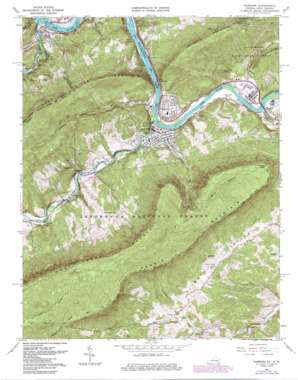
Narrows Topo Map Virginia
To zoom in, hover over the map of Narrows
USGS Topo Quad 37080c7 - 1:24,000 scale
| Topo Map Name: | Narrows |
| USGS Topo Quad ID: | 37080c7 |
| Print Size: | ca. 21 1/4" wide x 27" high |
| Southeast Coordinates: | 37.25° N latitude / 80.75° W longitude |
| Map Center Coordinates: | 37.3125° N latitude / 80.8125° W longitude |
| U.S. States: | VA, WV |
| Filename: | o37080c7.jpg |
| Download Map JPG Image: | Narrows topo map 1:24,000 scale |
| Map Type: | Topographic |
| Topo Series: | 7.5´ |
| Map Scale: | 1:24,000 |
| Source of Map Images: | United States Geological Survey (USGS) |
| Alternate Map Versions: |
Narrows VA 1965, updated 1966 Download PDF Buy paper map Narrows VA 1965, updated 1975 Download PDF Buy paper map Narrows VA 1965, updated 1977 Download PDF Buy paper map Narrows VA 1965, updated 1986 Download PDF Buy paper map Narrows VA 1998, updated 2000 Download PDF Buy paper map Narrows VA 2011 Download PDF Buy paper map Narrows VA 2013 Download PDF Buy paper map Narrows VA 2016 Download PDF Buy paper map |
| FStopo: | US Forest Service topo Narrows is available: Download FStopo PDF Download FStopo TIF |
1:24,000 Topo Quads surrounding Narrows
> Back to 37080a1 at 1:100,000 scale
> Back to 37080a1 at 1:250,000 scale
> Back to U.S. Topo Maps home
Narrows topo map: Gazetteer
Narrows: Bridges
Anderson E Shumate Memorial Bridge elevation 463m 1519′Andrew S Rowan Bridge elevation 454m 1489′
Bridge Number 2 elevation 485m 1591′
Narrows: Dams
Glen Lyn Flyash Dam elevation 470m 1541′Narrows: Gaps
The Narrows elevation 486m 1594′Narrows: Populated Places
Bluff City elevation 488m 1601′French elevation 504m 1653′
Glen Lyn elevation 510m 1673′
Narrows elevation 471m 1545′
North Pearisburg elevation 487m 1597′
Shumate elevation 482m 1581′
Thessalia elevation 636m 2086′
Narrows: Reservoirs
Glen Lyn Flyash Pond elevation 470m 1541′Narrows Reservoir elevation 623m 2043′
Narrows: Ridges
Hemlock Ridge elevation 753m 2470′Piney Ridge elevation 806m 2644′
Narrows: Streams
Adair Run elevation 458m 1502′Adair Run elevation 458m 1502′
East River elevation 460m 1509′
Mercy Branch elevation 729m 2391′
Mill Creek elevation 470m 1541′
Piney Creek elevation 457m 1499′
Stillhouse Branch elevation 488m 1601′
Wolf Creek elevation 463m 1519′
Narrows: Summits
Angels Rest elevation 1105m 3625′Pearis Mountain elevation 1148m 3766′
Sentinel Point elevation 1050m 3444′
Turnhole Knob elevation 682m 2237′
Narrows: Valleys
Wilburn Valley elevation 651m 2135′Narrows digital topo map on disk
Buy this Narrows topo map showing relief, roads, GPS coordinates and other geographical features, as a high-resolution digital map file on DVD:
Western Virginia & Southern West Virginia
Buy digital topo maps: Western Virginia & Southern West Virginia


