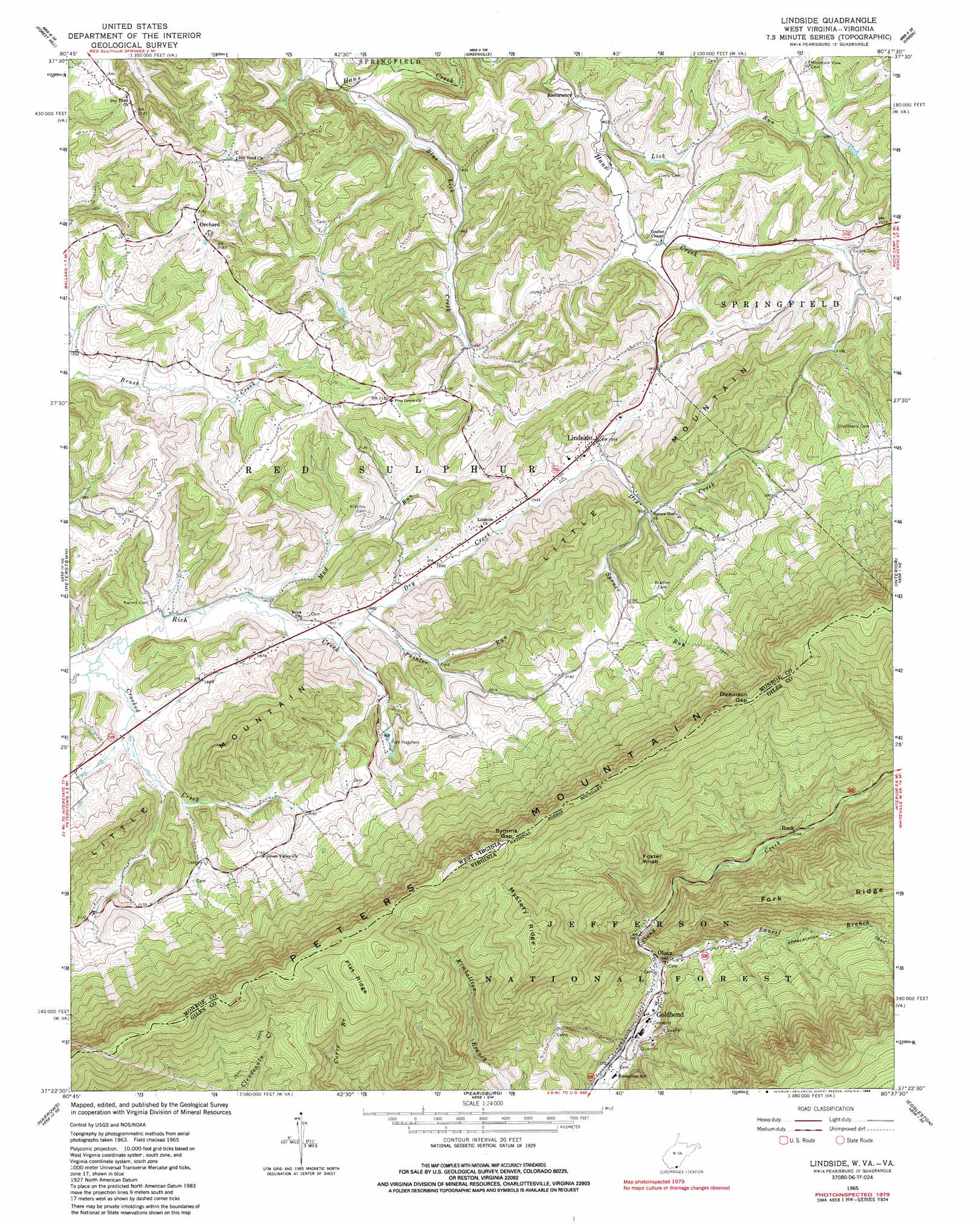
Lindside Topo Map West Virginia
To zoom in, hover over the map of Lindside
USGS Topo Quad 37080d6 - 1:24,000 scale
| Topo Map Name: | Lindside |
| USGS Topo Quad ID: | 37080d6 |
| Print Size: | ca. 21 1/4" wide x 27" high |
| Southeast Coordinates: | 37.375° N latitude / 80.625° W longitude |
| Map Center Coordinates: | 37.4375° N latitude / 80.6875° W longitude |
| U.S. States: | WV, VA |
| Filename: | o37080d6.jpg |
| Download Map JPG Image: | Lindside topo map 1:24,000 scale |
| Map Type: | Topographic |
| Topo Series: | 7.5´ |
| Map Scale: | 1:24,000 |
| Source of Map Images: | United States Geological Survey (USGS) |
| Alternate Map Versions: |
Lindside WV 1965, updated 1967 Download PDF Buy paper map Lindside WV 1965, updated 1979 Download PDF Buy paper map Lindside WV 1965, updated 1985 Download PDF Buy paper map Lindside WV 1998, updated 2001 Download PDF Buy paper map Lindside WV 2011 Download PDF Buy paper map Lindside WV 2014 Download PDF Buy paper map Lindside WV 2016 Download PDF Buy paper map |
| FStopo: | US Forest Service topo Lindside is available: Download FStopo PDF Download FStopo TIF |
1:24,000 Topo Quads surrounding Lindside
Hinton |
Talcott |
Alderson |
Fort Spring |
Ronceverte |
Pipestem |
Forest Hill |
Greenville |
Union |
Gap Mills |
Lerona |
Peterstown |
Lindside |
Interior |
Waiteville |
Oakvale |
Narrows |
Pearisburg |
Eggleston |
Newport |
Mechanicsburg |
White Gate |
Staffordsville |
Radford North |
Blacksburg |
> Back to 37080a1 at 1:100,000 scale
> Back to 37080a1 at 1:250,000 scale
> Back to U.S. Topo Maps home
Lindside topo map: Gazetteer
Lindside: Gaps
Dickinson Gap elevation 1008m 3307′Dickinson Gap elevation 1002m 3287′
Narrows of Hans Creek elevation 561m 1840′
Symms Gap elevation 996m 3267′
Symms Gap elevation 999m 3277′
Lindside: Populated Places
Assurance elevation 578m 1896′Goldbond elevation 546m 1791′
Lindside elevation 608m 1994′
Olean elevation 575m 1886′
Ronk elevation 634m 2080′
Lindside: Post Offices
Lindside Post Office elevation 611m 2004′Lindside: Ridges
Flat Ridge elevation 1009m 3310′Fork Ridge elevation 918m 3011′
Mystery Ridge elevation 970m 3182′
Lindside: Springs
Martin Spring elevation 612m 2007′Mercer Anglers Club Spring elevation 589m 1932′
Monroe County Spring elevation 583m 1912′
Rich Creek Spring elevation 585m 1919′
Lindside: Streams
Blue Lick Creek elevation 517m 1696′Crooked Creek elevation 550m 1804′
Dry Creek elevation 565m 1853′
Laurel Branch elevation 563m 1847′
Lick Run elevation 575m 1886′
Mud Run elevation 557m 1827′
Painter Run elevation 565m 1853′
Spruce Run elevation 616m 2020′
Lindside: Summits
Foster Knob elevation 868m 2847′Lindside digital topo map on disk
Buy this Lindside topo map showing relief, roads, GPS coordinates and other geographical features, as a high-resolution digital map file on DVD:
Western Virginia & Southern West Virginia
Buy digital topo maps: Western Virginia & Southern West Virginia