Pipestem Topo Map West Virginia
To zoom in, hover over the map of Pipestem
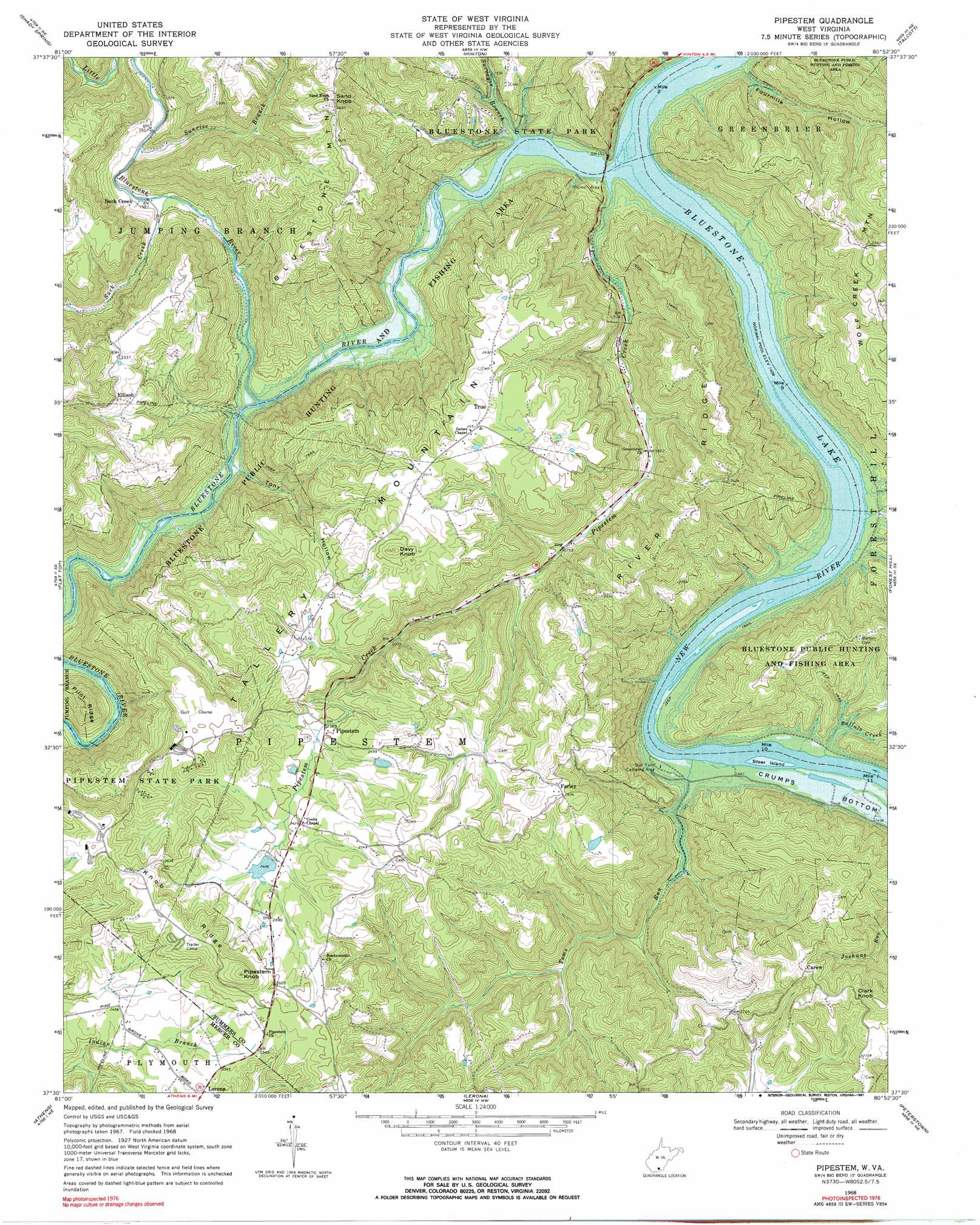
USGS Topo Quad 37080e8 - 1:24,000 scale
| Topo Map Name: | Pipestem |
| USGS Topo Quad ID: | 37080e8 |
| Print Size: | ca. 21 1/4" wide x 27" high |
| Southeast Coordinates: | 37.5° N latitude / 80.875° W longitude |
| Map Center Coordinates: | 37.5625° N latitude / 80.9375° W longitude |
| U.S. State: | WV |
| Filename: | o37080e8.jpg |
| Download Map JPG Image: | Pipestem topo map 1:24,000 scale |
| Map Type: | Topographic |
| Topo Series: | 7.5´ |
| Map Scale: | 1:24,000 |
| Source of Map Images: | United States Geological Survey (USGS) |
| Alternate Map Versions: |
Pipestem WV 1968, updated 1971 Download PDF Buy paper map Pipestem WV 1968, updated 1991 Download PDF Buy paper map Pipestem WV 1998, updated 2000 Download PDF Buy paper map Pipestem WV 2011 Download PDF Buy paper map Pipestem WV 2014 Download PDF Buy paper map Pipestem WV 2016 Download PDF Buy paper map |
1:24,000 Topo Quads surrounding Pipestem
Beckley |
Prince |
Meadow Creek |
Meadow Bridge |
Dawson |
Crab Orchard |
Shady Spring |
Hinton |
Talcott |
Alderson |
Odd |
Flat Top |
Pipestem |
Forest Hill |
Greenville |
Matoaka |
Athens |
Lerona |
Peterstown |
Lindside |
Bluefield |
Princeton |
Oakvale |
Narrows |
Pearisburg |
> Back to 37080e1 at 1:100,000 scale
> Back to 37080a1 at 1:250,000 scale
> Back to U.S. Topo Maps home
Pipestem topo map: Gazetteer
Pipestem: Crossings
Haines Ferry (historical) elevation 434m 1423′Pipestem: Dams
Sun Valley Lake Dam elevation 739m 2424′Pipestem: Falls
Bull Falls elevation 433m 1420′Pipestem: Islands
Steer Island elevation 433m 1420′Pipestem: Parks
Bluestone Lake Wildlife Management Area elevation 530m 1738′Bluestone National Scenic River elevation 499m 1637′
Bluestone State Park elevation 527m 1729′
Pipestem State Park elevation 664m 2178′
Pipestem: Populated Places
Carew elevation 692m 2270′Ellison elevation 713m 2339′
Farley elevation 733m 2404′
Lilly (historical) elevation 488m 1601′
Pipestem elevation 726m 2381′
Suck Creek elevation 482m 1581′
True elevation 750m 2460′
Warford (historical) elevation 434m 1423′
Pipestem: Post Offices
Pipestem Post Office elevation 736m 2414′True Post Office elevation 750m 2460′
Pipestem: Reservoirs
Long Branch Lake elevation 816m 2677′Sun Valley Lake elevation 739m 2424′
Pipestem: Ridges
Knob Ridge elevation 838m 2749′River Ridge elevation 755m 2477′
Pipestem: Streams
Bluestone River elevation 434m 1423′Buffalo Creek elevation 433m 1420′
Little Bluestone River elevation 441m 1446′
Parker Creek elevation 520m 1706′
Pipestem Creek elevation 434m 1423′
Suck Creek elevation 480m 1574′
Sunrise Branch elevation 497m 1630′
Surveyor Branch elevation 443m 1453′
Toms Run elevation 433m 1420′
Pipestem: Summits
Bluestone Mountain elevation 756m 2480′Clark Knob elevation 739m 2424′
Davy Knob elevation 831m 2726′
Pipestem Knob elevation 904m 2965′
Sand Knob elevation 749m 2457′
Tallery Mountain elevation 829m 2719′
Pipestem: Valleys
Fourmile Hollow elevation 437m 1433′Tony Hollow elevation 461m 1512′
Pipestem digital topo map on disk
Buy this Pipestem topo map showing relief, roads, GPS coordinates and other geographical features, as a high-resolution digital map file on DVD:
Western Virginia & Southern West Virginia
Buy digital topo maps: Western Virginia & Southern West Virginia