Fort Spring Topo Map West Virginia
To zoom in, hover over the map of Fort Spring
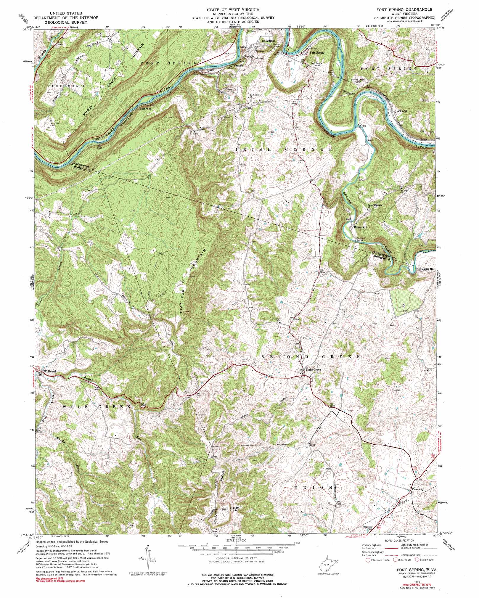
USGS Topo Quad 37080f5 - 1:24,000 scale
| Topo Map Name: | Fort Spring |
| USGS Topo Quad ID: | 37080f5 |
| Print Size: | ca. 21 1/4" wide x 27" high |
| Southeast Coordinates: | 37.625° N latitude / 80.5° W longitude |
| Map Center Coordinates: | 37.6875° N latitude / 80.5625° W longitude |
| U.S. State: | WV |
| Filename: | o37080f5.jpg |
| Download Map JPG Image: | Fort Spring topo map 1:24,000 scale |
| Map Type: | Topographic |
| Topo Series: | 7.5´ |
| Map Scale: | 1:24,000 |
| Source of Map Images: | United States Geological Survey (USGS) |
| Alternate Map Versions: |
Fort Spring WV 1971, updated 1975 Download PDF Buy paper map Fort Spring WV 1971, updated 1990 Download PDF Buy paper map Fort Spring WV 2011 Download PDF Buy paper map Fort Spring WV 2014 Download PDF Buy paper map Fort Spring WV 2016 Download PDF Buy paper map |
1:24,000 Topo Quads surrounding Fort Spring
Rainelle |
Rupert |
Cornstalk |
Williamsburg |
Anthony |
Meadow Bridge |
Dawson |
Asbury |
Lewisburg |
White Sulphur Springs |
Talcott |
Alderson |
Fort Spring |
Ronceverte |
Glace |
Forest Hill |
Greenville |
Union |
Gap Mills |
Paint Bank |
Peterstown |
Lindside |
Interior |
Waiteville |
Craig Springs |
> Back to 37080e1 at 1:100,000 scale
> Back to 37080a1 at 1:250,000 scale
> Back to U.S. Topo Maps home
Fort Spring topo map: Gazetteer
Fort Spring: Bridges
Hokes Mill Covered Bridge elevation 511m 1676′Fort Spring: Crossings
Stephens Ferry (historical) elevation 487m 1597′Fort Spring: Populated Places
Fort Spring elevation 498m 1633′Frazier elevation 494m 1620′
Half Way elevation 482m 1581′
Hokes Mill elevation 519m 1702′
Nickells Mill elevation 539m 1768′
Pickaway elevation 662m 2171′
Rockland elevation 508m 1666′
Sinks Grove elevation 670m 2198′
Snowflake elevation 510m 1673′
Wolfcreek elevation 487m 1597′
Fort Spring: Post Offices
Fort Spring Post Office elevation 496m 1627′Sinks Grove Post Office elevation 670m 2198′
Wolfcreek Post Office elevation 492m 1614′
Fort Spring: Springs
Harry Campbell Spring elevation 663m 2175′John Kirby Spring elevation 591m 1938′
Miller Spring elevation 616m 2020′
Rockland Spring elevation 500m 1640′
Fort Spring: Streams
Broad Run elevation 481m 1578′Hardy Run elevation 489m 1604′
Second Creek elevation 493m 1617′
Fort Spring: Summits
Bickett Knob elevation 1014m 3326′Flat Top Mountain elevation 975m 3198′
Fort Spring: Tunnels
Fort Spring Tunnel elevation 603m 1978′Manns Tunnel elevation 576m 1889′
Second Creek Tunnel elevation 587m 1925′
Fort Spring: Valleys
Scott Hollow elevation 620m 2034′Fort Spring digital topo map on disk
Buy this Fort Spring topo map showing relief, roads, GPS coordinates and other geographical features, as a high-resolution digital map file on DVD:
Western Virginia & Southern West Virginia
Buy digital topo maps: Western Virginia & Southern West Virginia