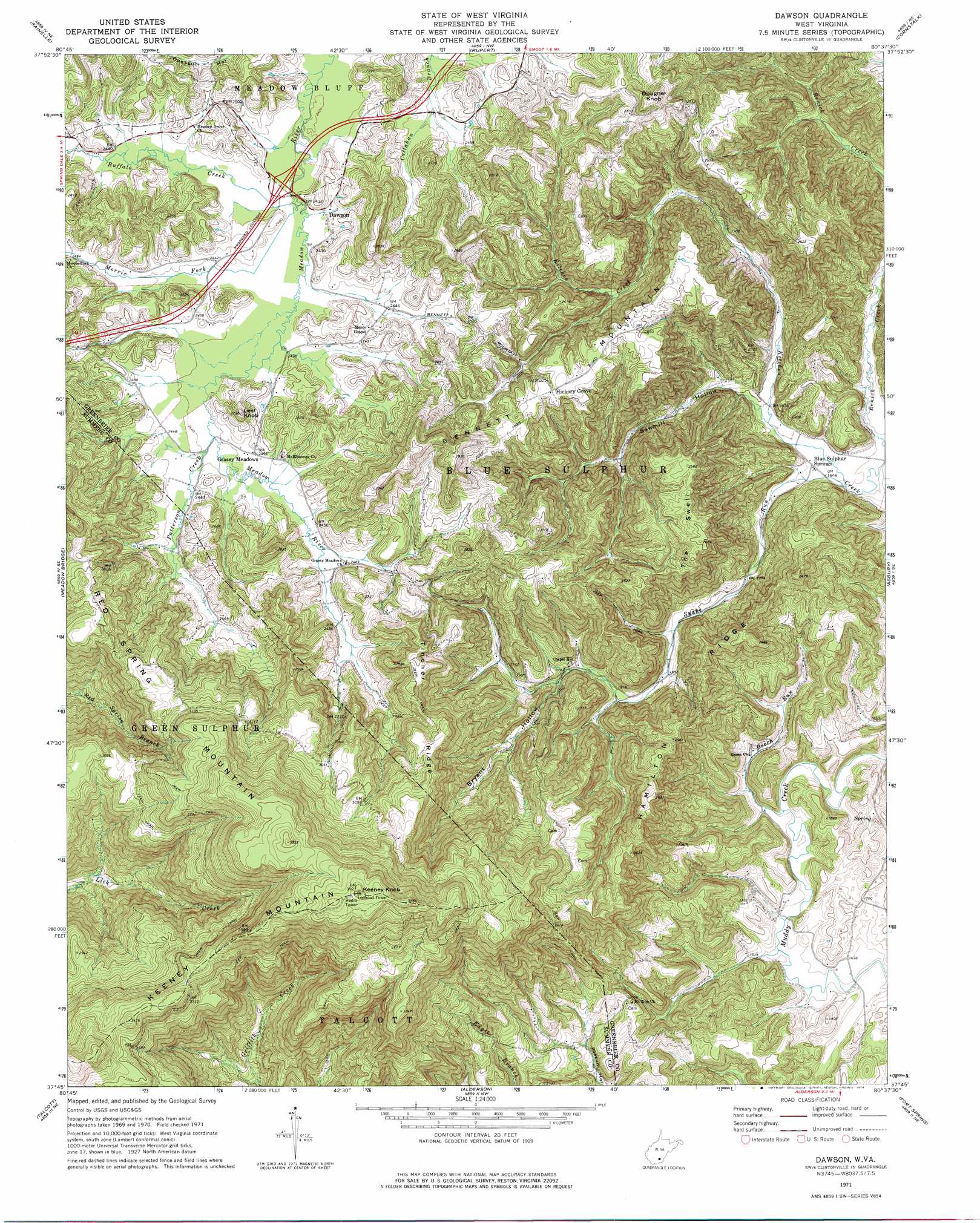
Dawson Topo Map West Virginia
To zoom in, hover over the map of Dawson
USGS Topo Quad 37080g6 - 1:24,000 scale
| Topo Map Name: | Dawson |
| USGS Topo Quad ID: | 37080g6 |
| Print Size: | ca. 21 1/4" wide x 27" high |
| Southeast Coordinates: | 37.75° N latitude / 80.625° W longitude |
| Map Center Coordinates: | 37.8125° N latitude / 80.6875° W longitude |
| U.S. State: | WV |
| Filename: | o37080g6.jpg |
| Download Map JPG Image: | Dawson topo map 1:24,000 scale |
| Map Type: | Topographic |
| Topo Series: | 7.5´ |
| Map Scale: | 1:24,000 |
| Source of Map Images: | United States Geological Survey (USGS) |
| Alternate Map Versions: |
Dawson WV 1971, updated 1974 Download PDF Buy paper map Dawson WV 2011 Download PDF Buy paper map Dawson WV 2014 Download PDF Buy paper map Dawson WV 2016 Download PDF Buy paper map |
1:24,000 Topo Quads surrounding Dawson
Winona |
Corliss |
Quinwood |
Duo |
Trout |
Danese |
Rainelle |
Rupert |
Cornstalk |
Williamsburg |
Meadow Creek |
Meadow Bridge |
Dawson |
Asbury |
Lewisburg |
Hinton |
Talcott |
Alderson |
Fort Spring |
Ronceverte |
Pipestem |
Forest Hill |
Greenville |
Union |
Gap Mills |
> Back to 37080e1 at 1:100,000 scale
> Back to 37080a1 at 1:250,000 scale
> Back to U.S. Topo Maps home
Dawson topo map: Gazetteer
Dawson: Crossings
Interchange 150 elevation 743m 2437′Dawson: Populated Places
Blue Sulphur Springs elevation 504m 1653′Dawson elevation 742m 2434′
Grassy Meadows elevation 748m 2454′
Hickory Grove elevation 801m 2627′
Dawson: Post Offices
Grassy Meadows Post Office elevation 748m 2454′Dawson: Ridges
Hamilton Ridge elevation 714m 2342′Tincher Ridge elevation 889m 2916′
Dawson: Springs
Blue Sulphur Spring elevation 504m 1653′Robert Bennett Spring elevation 588m 1929′
Dawson: Streams
Beech Run elevation 493m 1617′Buffalo Creek elevation 738m 2421′
Morris Fork elevation 738m 2421′
Patterson Creek elevation 744m 2440′
Snake Run elevation 501m 1643′
Dawson: Summits
Bennett Mountain elevation 892m 2926′Dougher Knob elevation 878m 2880′
Keeney Knob elevation 1195m 3920′
Leef Knob elevation 827m 2713′
Red Spring Mountain elevation 1169m 3835′
Sassafras Knob elevation 1115m 3658′
The Swell elevation 794m 2604′
Dawson: Valleys
Bryant Hollow elevation 617m 2024′Sawmill Hollow elevation 512m 1679′
Dawson digital topo map on disk
Buy this Dawson topo map showing relief, roads, GPS coordinates and other geographical features, as a high-resolution digital map file on DVD:
Western Virginia & Southern West Virginia
Buy digital topo maps: Western Virginia & Southern West Virginia