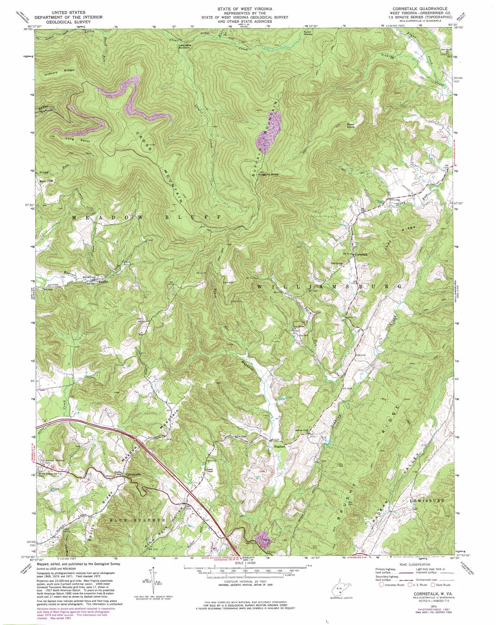
Cornstalk Topo Map West Virginia
To zoom in, hover over the map of Cornstalk
USGS Topo Quad 37080h5 - 1:24,000 scale
| Topo Map Name: | Cornstalk |
| USGS Topo Quad ID: | 37080h5 |
| Print Size: | ca. 21 1/4" wide x 27" high |
| Southeast Coordinates: | 37.875° N latitude / 80.5° W longitude |
| Map Center Coordinates: | 37.9375° N latitude / 80.5625° W longitude |
| U.S. State: | WV |
| Filename: | o37080h5.jpg |
| Download Map JPG Image: | Cornstalk topo map 1:24,000 scale |
| Map Type: | Topographic |
| Topo Series: | 7.5´ |
| Map Scale: | 1:24,000 |
| Source of Map Images: | United States Geological Survey (USGS) |
| Alternate Map Versions: |
Cornstalk WV 1972, updated 1974 Download PDF Buy paper map Cornstalk WV 1972, updated 1982 Download PDF Buy paper map Cornstalk WV 2011 Download PDF Buy paper map Cornstalk WV 2014 Download PDF Buy paper map Cornstalk WV 2016 Download PDF Buy paper map |
1:24,000 Topo Quads surrounding Cornstalk
Mount Nebo |
Nettie |
Richwood |
Fork Mountain |
Lobelia |
Corliss |
Quinwood |
Duo |
Trout |
Droop |
Rainelle |
Rupert |
Cornstalk |
Williamsburg |
Anthony |
Meadow Bridge |
Dawson |
Asbury |
Lewisburg |
White Sulphur Springs |
Talcott |
Alderson |
Fort Spring |
Ronceverte |
Glace |
> Back to 37080e1 at 1:100,000 scale
> Back to 37080a1 at 1:250,000 scale
> Back to U.S. Topo Maps home
Cornstalk topo map: Gazetteer
Cornstalk: Basins
LaFayette Bottom elevation 855m 2805′Cornstalk: Capes
Long Point elevation 1143m 3750′Cornstalk: Populated Places
Clintonville elevation 805m 2641′Cornstalk elevation 659m 2162′
Hughart elevation 628m 2060′
Kieffer elevation 761m 2496′
Rock Cliff elevation 878m 2880′
Cornstalk: Post Offices
Clintonville Post Office elevation 802m 2631′Cornstalk Post Office elevation 659m 2162′
Kieffer Post Office elevation 765m 2509′
Cornstalk: Ridges
Brushy Ridge elevation 778m 2552′Hickory Ridge elevation 1184m 3884′
Judy Ridge elevation 772m 2532′
Cornstalk: Springs
Enox Spring elevation 662m 2171′Johnson Truck Spring elevation 708m 2322′
Mrs Cochran Spring elevation 824m 2703′
Russell Haynes Spring elevation 930m 3051′
Cornstalk: Streams
Beech Run elevation 832m 2729′Flynn Creek elevation 667m 2188′
Hughart Creek elevation 611m 2004′
Kuhn Branch elevation 868m 2847′
Laurel Creek elevation 851m 2791′
Roach Run elevation 632m 2073′
Stong Run elevation 657m 2155′
Tater Run elevation 630m 2066′
Wallace Branch elevation 862m 2828′
Cornstalk: Summits
Buffalo Mountain elevation 1204m 3950′Cross Mountain elevation 1271m 4169′
Huggins Knob elevation 1204m 3950′
Meadow Mountain elevation 826m 2709′
Rose Knob elevation 1071m 3513′
Cornstalk digital topo map on disk
Buy this Cornstalk topo map showing relief, roads, GPS coordinates and other geographical features, as a high-resolution digital map file on DVD:
Western Virginia & Southern West Virginia
Buy digital topo maps: Western Virginia & Southern West Virginia