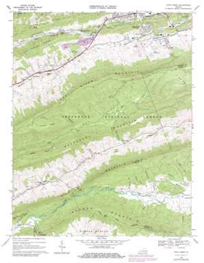
Cove Creek Topo Map Virginia
To zoom in, hover over the map of Cove Creek
USGS Topo Quad 37081b3 - 1:24,000 scale
| Topo Map Name: | Cove Creek |
| USGS Topo Quad ID: | 37081b3 |
| Print Size: | ca. 21 1/4" wide x 27" high |
| Southeast Coordinates: | 37.125° N latitude / 81.25° W longitude |
| Map Center Coordinates: | 37.1875° N latitude / 81.3125° W longitude |
| U.S. State: | VA |
| Filename: | o37081b3.jpg |
| Download Map JPG Image: | Cove Creek topo map 1:24,000 scale |
| Map Type: | Topographic |
| Topo Series: | 7.5´ |
| Map Scale: | 1:24,000 |
| Source of Map Images: | United States Geological Survey (USGS) |
| Alternate Map Versions: |
Nye Cove VA 1935 Download PDF Buy paper map Cove Creek VA 1968, updated 1971 Download PDF Buy paper map Cove Creek VA 1968, updated 1979 Download PDF Buy paper map Cove Creek VA 2011 Download PDF Buy paper map Cove Creek VA 2013 Download PDF Buy paper map Cove Creek VA 2016 Download PDF Buy paper map |
| FStopo: | US Forest Service topo Cove Creek is available: Download FStopo PDF Download FStopo TIF |
1:24,000 Topo Quads surrounding Cove Creek
> Back to 37081a1 at 1:100,000 scale
> Back to 37080a1 at 1:250,000 scale
> Back to U.S. Topo Maps home
Cove Creek topo map: Gazetteer
Cove Creek: Bays
Nye Cove elevation 755m 2477′Cove Creek: Dams
Gose Mill Dam elevation 923m 3028′Cove Creek: Gaps
Crabtree Gap elevation 916m 3005′Doe Hollow Gap elevation 889m 2916′
The Gap elevation 923m 3028′
Cove Creek: Populated Places
Cove Creek elevation 716m 2349′Gose Mill elevation 926m 3038′
Saint Clair elevation 750m 2460′
Sam elevation 759m 2490′
Shannandale elevation 781m 2562′
Shawver Mill elevation 769m 2522′
West Graham elevation 755m 2477′
Cove Creek: Ridges
Chestnut Ridge elevation 1185m 3887′Stony Ridge elevation 908m 2979′
Cove Creek: Springs
Dills Spring elevation 745m 2444′Cove Creek: Streams
Burkes Garden Creek elevation 899m 2949′Carter Branch elevation 707m 2319′
Clear Spring Branch elevation 708m 2322′
Cove Creek elevation 716m 2349′
Deavers Branch elevation 714m 2342′
East Fork Cove Creek elevation 755m 2477′
Hemppatch Branch elevation 749m 2457′
Indianfield Branch elevation 720m 2362′
Kidd Branch elevation 720m 2362′
Little Creek elevation 899m 2949′
Mudley Branch elevation 856m 2808′
Oneida Branch elevation 804m 2637′
Perry Branch elevation 733m 2404′
Wagner Trace Branch elevation 730m 2395′
West Fork Cove Creek elevation 755m 2477′
Wrights Valley Creek elevation 726m 2381′
Cove Creek: Summits
Buckhorn Mountain elevation 952m 3123′Gose Knob elevation 1244m 4081′
Scott Knob elevation 955m 3133′
Cove Creek: Valleys
Wrights Valley elevation 755m 2477′Cove Creek digital topo map on disk
Buy this Cove Creek topo map showing relief, roads, GPS coordinates and other geographical features, as a high-resolution digital map file on DVD:
Western Virginia & Southern West Virginia
Buy digital topo maps: Western Virginia & Southern West Virginia


