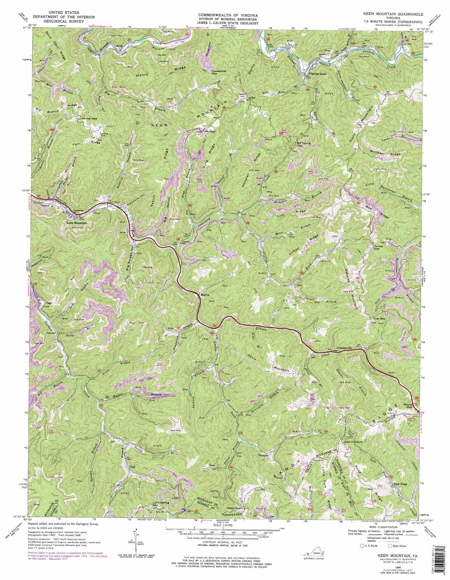
Keen Mountain Topo Map Virginia
To zoom in, hover over the map of Keen Mountain
USGS Topo Quad 37081b8 - 1:24,000 scale
| Topo Map Name: | Keen Mountain |
| USGS Topo Quad ID: | 37081b8 |
| Print Size: | ca. 21 1/4" wide x 27" high |
| Southeast Coordinates: | 37.125° N latitude / 81.875° W longitude |
| Map Center Coordinates: | 37.1875° N latitude / 81.9375° W longitude |
| U.S. State: | VA |
| Filename: | o37081b8.jpg |
| Download Map JPG Image: | Keen Mountain topo map 1:24,000 scale |
| Map Type: | Topographic |
| Topo Series: | 7.5´ |
| Map Scale: | 1:24,000 |
| Source of Map Images: | United States Geological Survey (USGS) |
| Alternate Map Versions: |
Pistol Gap VA 1935 Download PDF Buy paper map Keen Mountain VA 1968, updated 1972 Download PDF Buy paper map Keen Mountain VA 1968, updated 1978 Download PDF Buy paper map Keen Mountain VA 1968, updated 1978 Download PDF Buy paper map Keen Mountain VA 2010 Download PDF Buy paper map Keen Mountain VA 2013 Download PDF Buy paper map Keen Mountain VA 2016 Download PDF Buy paper map |
1:24,000 Topo Quads surrounding Keen Mountain
Jamboree |
Hurley |
Panther |
Iaeger |
Davy |
Harman |
Grundy |
Patterson |
Bradshaw |
War |
Prater |
Vansant |
Keen Mountain |
Jewell Ridge |
Amonate |
Duty |
Big A Mountain |
Honaker |
Richlands |
Pounding Mill |
Carbo |
Lebanon |
Elk Garden |
Saltville |
Broadford |
> Back to 37081a1 at 1:100,000 scale
> Back to 37080a1 at 1:250,000 scale
> Back to U.S. Topo Maps home
Keen Mountain topo map: Gazetteer
Keen Mountain: Gaps
Bill Young Gap elevation 667m 2188′Coal Gap elevation 766m 2513′
Gap of Sandy elevation 779m 2555′
Horseshoe Gap elevation 719m 2358′
Kennel Gap elevation 697m 2286′
Low Gap elevation 755m 2477′
Lynn Spring Gap elevation 807m 2647′
Pistol Gap elevation 797m 2614′
Shortt Gap elevation 757m 2483′
Turkey Gap elevation 751m 2463′
Keen Mountain: Populated Places
Clell elevation 564m 1850′Fork Ridge elevation 708m 2322′
Grimsleyville elevation 580m 1902′
Horn elevation 745m 2444′
Keen Mountain elevation 421m 1381′
Marvin elevation 485m 1591′
Page elevation 469m 1538′
Roth elevation 427m 1400′
Shack Mills elevation 466m 1528′
Vandyke elevation 580m 1902′
Keen Mountain: Ridges
Clifton Ridge elevation 763m 2503′Durg Ridge elevation 714m 2342′
Fork Ridge elevation 729m 2391′
Henry Ridge elevation 740m 2427′
Hog Ridge elevation 819m 2687′
Honaker Ridge elevation 732m 2401′
Lick Ridge elevation 746m 2447′
Little Fork Ridge elevation 806m 2644′
Ratliff Ridge elevation 744m 2440′
Wolfpen Ridge elevation 807m 2647′
Keen Mountain: Streams
Aus Keen Branch elevation 479m 1571′Betsy Branch elevation 564m 1850′
Big Branch elevation 493m 1617′
Big Branch elevation 425m 1394′
Bill Keen Branch elevation 493m 1617′
Bill Young Branch elevation 476m 1561′
Boyd Branch elevation 531m 1742′
Bridge Branch elevation 413m 1354′
Burnt Chestnut Branch elevation 483m 1584′
Carver Branch elevation 566m 1856′
Clifton Fork elevation 506m 1660′
Contrary Creek elevation 458m 1502′
Cove Branch elevation 593m 1945′
English Branch elevation 478m 1568′
Grassy Creek elevation 500m 1640′
Griffy Branch elevation 519m 1702′
Gum Branch elevation 454m 1489′
Hale Branch elevation 545m 1788′
Harry Branch elevation 492m 1614′
Honaker Branch elevation 535m 1755′
Jackson Branch elevation 519m 1702′
Jamison Creek elevation 704m 2309′
Laurel Fork elevation 496m 1627′
Loggy Bottom Branch elevation 488m 1601′
Mann Branch elevation 536m 1758′
Pistol Branch elevation 564m 1850′
Presley Branch elevation 530m 1738′
Ratliff Branch elevation 492m 1614′
Rocklick Branch elevation 431m 1414′
Sevenmile Branch elevation 548m 1797′
Shacks Branch elevation 583m 1912′
Trace Branch elevation 494m 1620′
Walker Branch elevation 509m 1669′
Whetstone Branch elevation 487m 1597′
Keen Mountain: Summits
Davis Mountain elevation 789m 2588′Horn Mountain elevation 811m 2660′
Keen Mountain elevation 834m 2736′
Osborne Mountain elevation 840m 2755′
Pilgrim Knob elevation 657m 2155′
Keen Mountain: Valleys
Big Hollow elevation 454m 1489′Big Skeggs Hollow elevation 448m 1469′
Ratliff Hollow elevation 470m 1541′
Richmond Hollow elevation 441m 1446′
Keen Mountain digital topo map on disk
Buy this Keen Mountain topo map showing relief, roads, GPS coordinates and other geographical features, as a high-resolution digital map file on DVD:
Western Virginia & Southern West Virginia
Buy digital topo maps: Western Virginia & Southern West Virginia