Bluefield Topo Map West Virginia
To zoom in, hover over the map of Bluefield
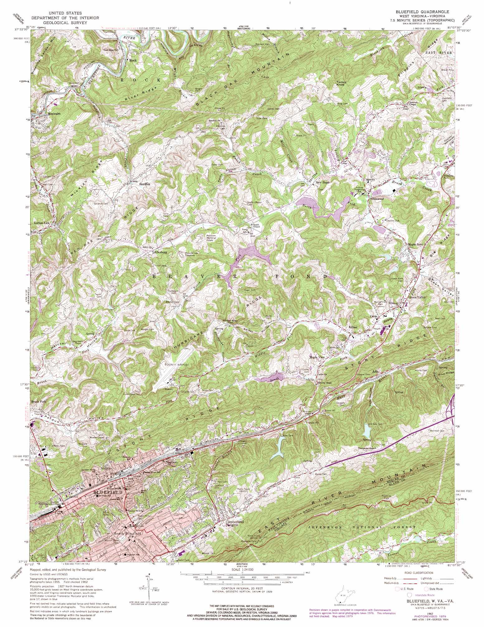
USGS Topo Quad 37081c2 - 1:24,000 scale
| Topo Map Name: | Bluefield |
| USGS Topo Quad ID: | 37081c2 |
| Print Size: | ca. 21 1/4" wide x 27" high |
| Southeast Coordinates: | 37.25° N latitude / 81.125° W longitude |
| Map Center Coordinates: | 37.3125° N latitude / 81.1875° W longitude |
| U.S. States: | WV, VA |
| Filename: | o37081c2.jpg |
| Download Map JPG Image: | Bluefield topo map 1:24,000 scale |
| Map Type: | Topographic |
| Topo Series: | 7.5´ |
| Map Scale: | 1:24,000 |
| Source of Map Images: | United States Geological Survey (USGS) |
| Alternate Map Versions: |
Bluefield WV 1962, updated 1964 Download PDF Buy paper map Bluefield WV 1962, updated 1972 Download PDF Buy paper map Bluefield WV 1962, updated 1979 Download PDF Buy paper map Bluefield WV 2011 Download PDF Buy paper map Bluefield WV 2014 Download PDF Buy paper map Bluefield WV 2016 Download PDF Buy paper map |
| FStopo: | US Forest Service topo Bluefield is available: Download FStopo PDF Download FStopo TIF |
1:24,000 Topo Quads surrounding Bluefield
Mullens |
Rhodell |
Odd |
Flat Top |
Pipestem |
Keystone |
Crumpler |
Matoaka |
Athens |
Lerona |
Anawalt |
Bramwell |
Bluefield |
Princeton |
Oakvale |
Tiptop |
Cove Creek |
Bastian |
Rocky Gap |
Mechanicsburg |
Hutchinson Rock |
Garden Mountain |
Big Bend |
Bland |
Long Spur |
> Back to 37081a1 at 1:100,000 scale
> Back to 37080a1 at 1:250,000 scale
> Back to U.S. Topo Maps home
Bluefield topo map: Gazetteer
Bluefield: Airports
Bluefield Regional Medical Center Heliport elevation 759m 2490′Mercer County Airport elevation 867m 2844′
Bluefield: Crossings
Interchange 1 elevation 772m 2532′Bluefield: Dams
Ada Dam elevation 817m 2680′Bluewell Water Supply Dam Number One elevation 774m 2539′
Bluewell Water Supply Dam Number Two elevation 807m 2647′
Brush Creek Structure Number 14 Dam elevation 738m 2421′
Brush Creek Structure Number 15 Dam elevation 743m 2437′
Brush Creek Structure Number 19a Dam elevation 756m 2480′
Brush Creek Structure Number 7a Dam elevation 775m 2542′
Brush Creek Structure Number Five Dam elevation 784m 2572′
Brush Creek Structure Number Four Dam elevation 745m 2444′
Brush Creek Structure Number Nine Dam elevation 774m 2539′
Brush Creek Structure Number Six Dam elevation 745m 2444′
Horton Dam elevation 737m 2417′
Old Ada Dam elevation 715m 2345′
Bluefield: Gaps
Stony Gap elevation 761m 2496′Bluefield: Parks
Bluefield Downtown Commercial Historic District elevation 806m 2644′Mitchell Stadium elevation 747m 2450′
Montvale Park elevation 794m 2604′
Wade Athletic field elevation 761m 2496′
Bluefield: Populated Places
Ada elevation 695m 2280′Bethel (historical) elevation 799m 2621′
Bluefield elevation 784m 2572′
Ceres elevation 742m 2434′
Crusher (historical) elevation 738m 2421′
Cumberland Heights elevation 816m 2677′
Edison elevation 745m 2444′
El Centro (historical) elevation 745m 2444′
Glenwood elevation 740m 2427′
Green Valley elevation 741m 2431′
Johnston Town elevation 796m 2611′
Littlesburg elevation 798m 2618′
Lorton Lick elevation 713m 2339′
Maple Acre elevation 744m 2440′
Maple View elevation 751m 2463′
New Hope elevation 750m 2460′
Rock elevation 664m 2178′
Sandlick elevation 786m 2578′
South Bluefield elevation 770m 2526′
Bluefield: Post Offices
Bluefield Post Office elevation 795m 2608′Rock Post Office elevation 676m 2217′
Bluefield: Reservoirs
Ada Lake elevation 817m 2680′Bluewell Dam Number One elevation 774m 2539′
Bluewell Dam Number Two elevation 807m 2647′
Doctor Daniel Hale Lake elevation 743m 2437′
Horton Lake elevation 737m 2417′
Bluefield: Ridges
Flippins Ridge elevation 803m 2634′Hurricane Ridge elevation 883m 2896′
Micajah Ridge elevation 842m 2762′
Red Oak Ridge elevation 816m 2677′
River Ridge elevation 841m 2759′
Bluefield: Springs
Ada Reservoir Spring elevation 715m 2345′Bluefield Spring elevation 971m 3185′
Norton Hollow Spring elevation 791m 2595′
Bluefield: Streams
Dyepot Branch elevation 666m 2185′Fussy Creek elevation 736m 2414′
Grassy Branch elevation 702m 2303′
Middle Fork Brush Creek elevation 742m 2434′
Mill Creek elevation 736m 2414′
North Fork Brush Creek elevation 734m 2408′
Sandlick Creek elevation 670m 2198′
Shelton Branch elevation 744m 2440′
South Fork Brush Creek elevation 734m 2408′
Spruce Branch elevation 667m 2188′
Widemouth Creek elevation 669m 2194′
Wright Branch elevation 664m 2178′
Bluefield: Summits
Black Oak Mountain elevation 994m 3261′Browning Lambert Mountain elevation 812m 2664′
Turkey Knob elevation 892m 2926′
Bluefield: Valleys
Dam Hollow elevation 676m 2217′Edison Hollow elevation 755m 2477′
Green Valley elevation 742m 2434′
Hatcher Hollow elevation 724m 2375′
Rocky Hollow elevation 749m 2457′
Stillhouse Hollow elevation 770m 2526′
Bluefield digital topo map on disk
Buy this Bluefield topo map showing relief, roads, GPS coordinates and other geographical features, as a high-resolution digital map file on DVD:
Western Virginia & Southern West Virginia
Buy digital topo maps: Western Virginia & Southern West Virginia