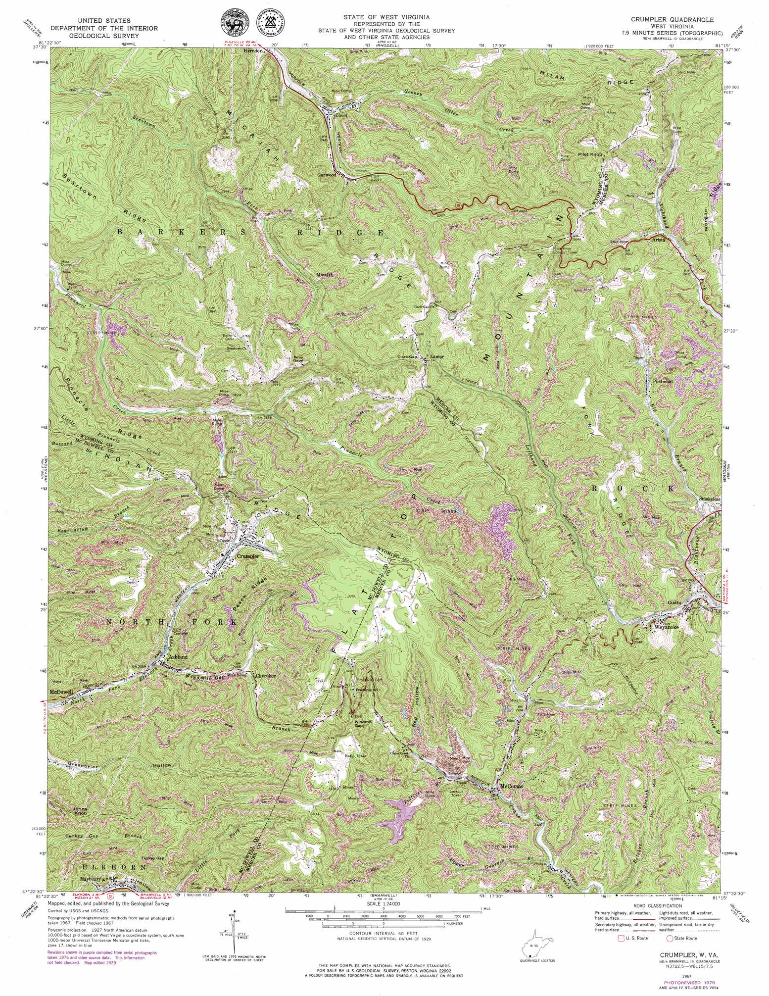
Crumpler Topo Map West Virginia
To zoom in, hover over the map of Crumpler
USGS Topo Quad 37081d3 - 1:24,000 scale
| Topo Map Name: | Crumpler |
| USGS Topo Quad ID: | 37081d3 |
| Print Size: | ca. 21 1/4" wide x 27" high |
| Southeast Coordinates: | 37.375° N latitude / 81.25° W longitude |
| Map Center Coordinates: | 37.4375° N latitude / 81.3125° W longitude |
| U.S. State: | WV |
| Filename: | o37081d3.jpg |
| Download Map JPG Image: | Crumpler topo map 1:24,000 scale |
| Map Type: | Topographic |
| Topo Series: | 7.5´ |
| Map Scale: | 1:24,000 |
| Source of Map Images: | United States Geological Survey (USGS) |
| Alternate Map Versions: |
Crumpler WV 1967, updated 1970 Download PDF Buy paper map Crumpler WV 1967, updated 1979 Download PDF Buy paper map Crumpler WV 2011 Download PDF Buy paper map Crumpler WV 2014 Download PDF Buy paper map Crumpler WV 2016 Download PDF Buy paper map |
1:24,000 Topo Quads surrounding Crumpler
Matheny |
Mcgraws |
Lester |
Crab Orchard |
Shady Spring |
Pineville |
Mullens |
Rhodell |
Odd |
Flat Top |
Welch |
Keystone |
Crumpler |
Matoaka |
Athens |
Gary |
Anawalt |
Bramwell |
Bluefield |
Princeton |
Tazewell North |
Tiptop |
Cove Creek |
Bastian |
Rocky Gap |
> Back to 37081a1 at 1:100,000 scale
> Back to 37080a1 at 1:250,000 scale
> Back to U.S. Topo Maps home
Crumpler topo map: Gazetteer
Crumpler: Dams
Beartown Fork Dam elevation 781m 2562′Boyds Branch Refuse Dam elevation 778m 2552′
East Fork of Crane Creek Dam elevation 769m 2522′
Gooney Otter Creek Dam elevation 769m 2522′
Lefthand Fork Dam elevation 764m 2506′
Payne Branch Dam elevation 755m 2477′
Tolliver Branch Dam elevation 792m 2598′
Crumpler: Gaps
Clark Gap elevation 836m 2742′Peters Gap elevation 885m 2903′
Turkey Gap elevation 819m 2687′
Windmill Gap elevation 928m 3044′
Crumpler: Populated Places
Algonquin (historical) elevation 782m 2565′Arista elevation 756m 2480′
Ashland elevation 645m 2116′
Black elevation 956m 3136′
Cherokee elevation 694m 2276′
Covel elevation 588m 1929′
Crumpler elevation 706m 2316′
Garwood elevation 599m 1965′
Giatto elevation 730m 2395′
Lamar elevation 827m 2713′
Lowe (historical) elevation 734m 2408′
McComas elevation 716m 2349′
Micajah elevation 711m 2332′
Piedmont elevation 740m 2427′
Smokeless elevation 732m 2401′
Weyanoke elevation 737m 2417′
Widemouth (historical) elevation 748m 2454′
Crumpler: Post Offices
Ashland Post Office elevation 641m 2103′Covel Post Office elevation 590m 1935′
Crumpler Post Office elevation 735m 2411′
McComas Post Office elevation 713m 2339′
Crumpler: Reservoirs
Crumpler Impoundment Number Two elevation 755m 2477′Tolliver Branch Lake elevation 792m 2598′
Crumpler: Ridges
Beartown Ridge elevation 814m 2670′Fork Ridge elevation 876m 2874′
Peach Ridge elevation 920m 3018′
Pinnacle Ridge elevation 846m 2775′
Crumpler: Springs
Dwight Shrewsbury Spring elevation 882m 2893′Harry S Thomas Spring elevation 951m 3120′
Crumpler: Streams
Big Branch elevation 723m 2372′Lefthand Fork Widemouth Creek elevation 721m 2365′
Righthand Fork Widemouth Creek elevation 721m 2365′
Tolliver Branch elevation 726m 2381′
Upper Georges Branch elevation 697m 2286′
Windmill Gap Branch elevation 639m 2096′
Crumpler: Summits
Johns Knob elevation 907m 2975′Pilot Knob elevation 995m 3264′
Crumpler: Valleys
Angle Hollow elevation 649m 2129′Red Hollow elevation 753m 2470′
Crumpler digital topo map on disk
Buy this Crumpler topo map showing relief, roads, GPS coordinates and other geographical features, as a high-resolution digital map file on DVD:
Western Virginia & Southern West Virginia
Buy digital topo maps: Western Virginia & Southern West Virginia