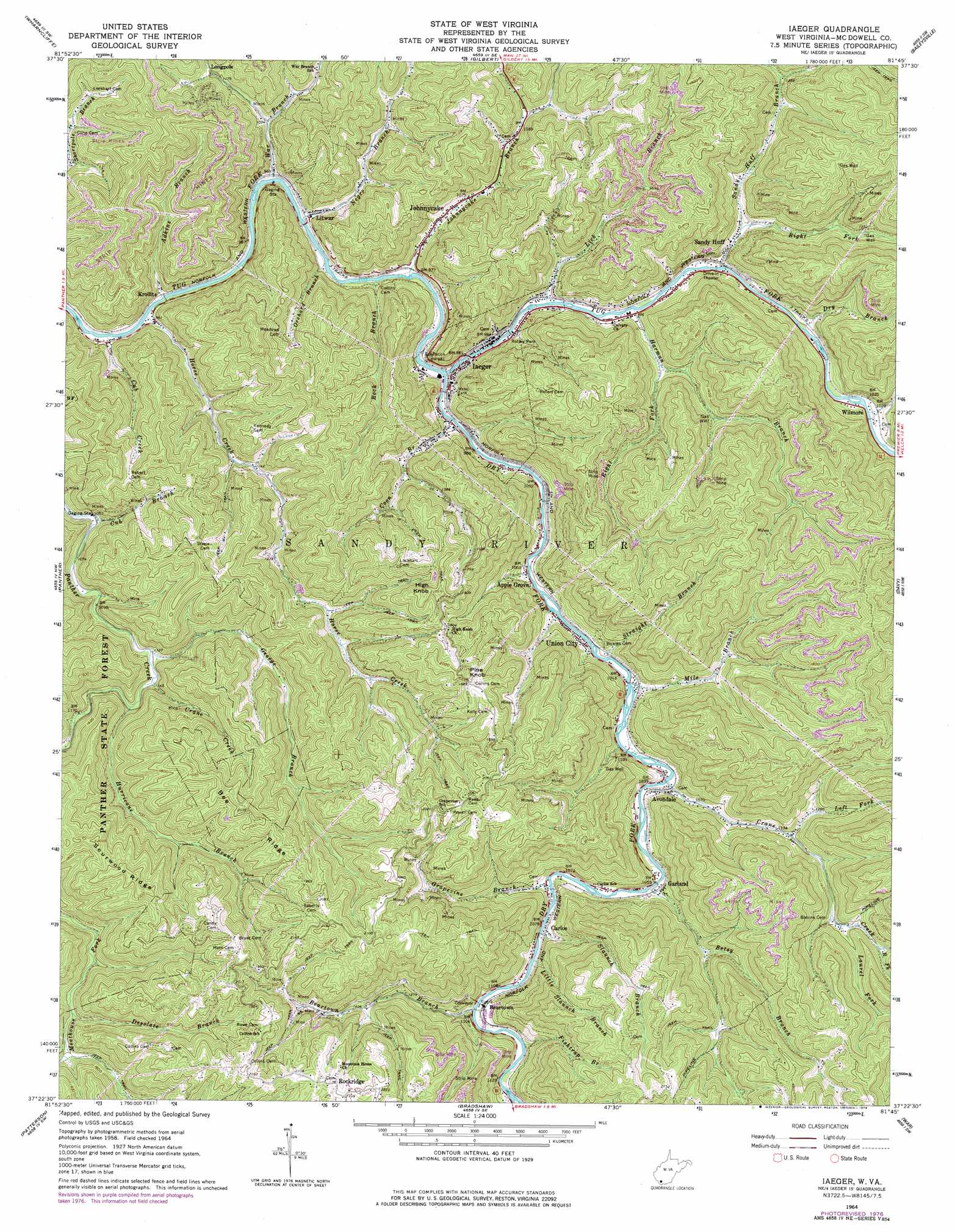
Iaeger Topo Map West Virginia
To zoom in, hover over the map of Iaeger
USGS Topo Quad 37081d7 - 1:24,000 scale
| Topo Map Name: | Iaeger |
| USGS Topo Quad ID: | 37081d7 |
| Print Size: | ca. 21 1/4" wide x 27" high |
| Southeast Coordinates: | 37.375° N latitude / 81.75° W longitude |
| Map Center Coordinates: | 37.4375° N latitude / 81.8125° W longitude |
| U.S. State: | WV |
| Filename: | o37081d7.jpg |
| Download Map JPG Image: | Iaeger topo map 1:24,000 scale |
| Map Type: | Topographic |
| Topo Series: | 7.5´ |
| Map Scale: | 1:24,000 |
| Source of Map Images: | United States Geological Survey (USGS) |
| Alternate Map Versions: |
Iaeger WV 1964, updated 1965 Download PDF Buy paper map Iaeger WV 1964, updated 1976 Download PDF Buy paper map Iaeger WV 1964, updated 1978 Download PDF Buy paper map Iaeger WV 2011 Download PDF Buy paper map Iaeger WV 2014 Download PDF Buy paper map Iaeger WV 2016 Download PDF Buy paper map |
1:24,000 Topo Quads surrounding Iaeger
Barnabus |
Man |
Mallory |
Oceana |
Matheny |
Majestic |
Wharncliffe |
Gilbert |
Baileysville |
Pineville |
Hurley |
Panther |
Iaeger |
Davy |
Welch |
Grundy |
Patterson |
Bradshaw |
War |
Gary |
Vansant |
Keen Mountain |
Jewell Ridge |
Amonate |
Tazewell North |
> Back to 37081a1 at 1:100,000 scale
> Back to 37080a1 at 1:250,000 scale
> Back to U.S. Topo Maps home
Iaeger topo map: Gazetteer
Iaeger: Populated Places
Apple Grove elevation 315m 1033′Avondale elevation 325m 1066′
Beartown elevation 336m 1102′
Carlos elevation 334m 1095′
Garland elevation 325m 1066′
Hull elevation 302m 990′
Iaeger elevation 300m 984′
Johnnycake elevation 320m 1049′
Krollitz elevation 294m 964′
Litwar elevation 293m 961′
Nacols elevation 306m 1003′
Rockridge elevation 679m 2227′
Sandy Huff elevation 309m 1013′
Union City elevation 306m 1003′
Wilmore elevation 313m 1026′
Iaeger: Ridges
Bee Ridge elevation 625m 2050′Sourwood Ridge elevation 623m 2043′
Iaeger: Streams
Adkins Branch elevation 285m 935′Beartown Branch elevation 334m 1095′
Betsy Branch elevation 318m 1043′
Coon Branch elevation 293m 961′
Crane Creek elevation 345m 1131′
Crane Creek elevation 311m 1020′
Cub Branch elevation 324m 1062′
Cub Creek elevation 283m 928′
Desolate Branch elevation 419m 1374′
Dry Branch elevation 302m 990′
Dry Fork elevation 292m 958′
Fishtrap Branch elevation 344m 1128′
George Branch elevation 342m 1122′
Grapevine Branch elevation 325m 1066′
Harman Branch elevation 299m 980′
Horse Creek elevation 290m 951′
Hurricane Branch elevation 351m 1151′
Johnnycake Branch elevation 289m 948′
Laurel Fork elevation 403m 1322′
Left Fork Crane Creek elevation 362m 1187′
Lick Branch elevation 295m 967′
Little Slaunch Branch elevation 330m 1082′
Mile Branch elevation 309m 1013′
Negro Branch elevation 288m 944′
Oldhouse Branch elevation 356m 1167′
Orchard Branch elevation 288m 944′
Right Fork Crane Creek elevation 435m 1427′
Right Fork Harman Branch elevation 327m 1072′
Right Fork Sandy Huff Branch elevation 314m 1030′
Rock Branch elevation 292m 958′
Sandy Huff Branch elevation 304m 997′
Slaunch Branch elevation 328m 1076′
Snipe Branch elevation 306m 1003′
Straight Branch elevation 304m 997′
War Branch elevation 290m 951′
Iaeger: Summits
High Knob elevation 626m 2053′Pine Knob elevation 629m 2063′
Iaeger: Valleys
Sal Gibson Hollow elevation 394m 1292′Iaeger digital topo map on disk
Buy this Iaeger topo map showing relief, roads, GPS coordinates and other geographical features, as a high-resolution digital map file on DVD:
Western Virginia & Southern West Virginia
Buy digital topo maps: Western Virginia & Southern West Virginia