Flat Top Topo Map West Virginia
To zoom in, hover over the map of Flat Top
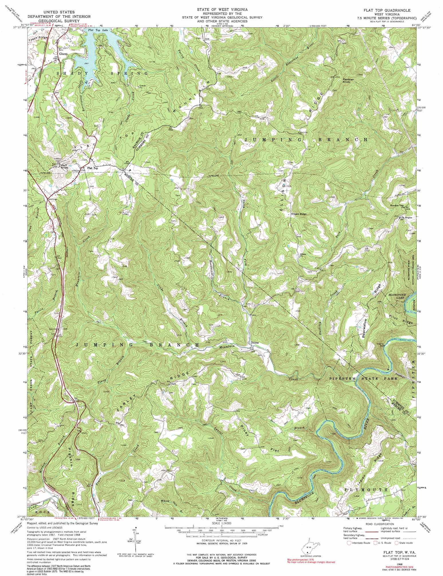
USGS Topo Quad 37081e1 - 1:24,000 scale
| Topo Map Name: | Flat Top |
| USGS Topo Quad ID: | 37081e1 |
| Print Size: | ca. 21 1/4" wide x 27" high |
| Southeast Coordinates: | 37.5° N latitude / 81° W longitude |
| Map Center Coordinates: | 37.5625° N latitude / 81.0625° W longitude |
| U.S. State: | WV |
| Filename: | o37081e1.jpg |
| Download Map JPG Image: | Flat Top topo map 1:24,000 scale |
| Map Type: | Topographic |
| Topo Series: | 7.5´ |
| Map Scale: | 1:24,000 |
| Source of Map Images: | United States Geological Survey (USGS) |
| Alternate Map Versions: |
Flat Top WV 1968, updated 1972 Download PDF Buy paper map Flat Top WV 1968, updated 1991 Download PDF Buy paper map Flat Top WV 2011 Download PDF Buy paper map Flat Top WV 2014 Download PDF Buy paper map Flat Top WV 2016 Download PDF Buy paper map |
1:24,000 Topo Quads surrounding Flat Top
Eccles |
Beckley |
Prince |
Meadow Creek |
Meadow Bridge |
Lester |
Crab Orchard |
Shady Spring |
Hinton |
Talcott |
Rhodell |
Odd |
Flat Top |
Pipestem |
Forest Hill |
Crumpler |
Matoaka |
Athens |
Lerona |
Peterstown |
Bramwell |
Bluefield |
Princeton |
Oakvale |
Narrows |
> Back to 37081e1 at 1:100,000 scale
> Back to 37080a1 at 1:250,000 scale
> Back to U.S. Topo Maps home
Flat Top topo map: Gazetteer
Flat Top: Crossings
Interchange 28 elevation 912m 2992′Flat Top: Flats
Piney Flat elevation 776m 2545′Flat Top: Populated Places
Dunns elevation 556m 1824′Ellison Ridge elevation 885m 2903′
Flat Top elevation 991m 3251′
Ghent elevation 910m 2985′
Flat Top: Post Offices
Flat Top Post Office elevation 991m 3251′Ghent Post Office elevation 909m 2982′
Flat Top: Ridges
Bearwallow Ridge elevation 812m 2664′Ellison Ridge elevation 950m 3116′
Ellison Ridge elevation 769m 2522′
Farley Ridge elevation 846m 2775′
Indian Ridge elevation 806m 2644′
Pigshin Ridge elevation 768m 2519′
Pilot Ridge elevation 578m 1896′
Flat Top: Springs
Farley Spring elevation 759m 2490′Flat Top: Streams
Beaverpond Branch elevation 885m 2903′Bee Branch elevation 493m 1617′
Cub Branch elevation 750m 2460′
Dustlick Creek elevation 501m 1643′
Glade Branch elevation 589m 1932′
Indian Branch elevation 481m 1578′
Laurel Creek elevation 514m 1686′
Meadow Branch elevation 605m 1984′
Mountain Creek elevation 476m 1561′
North Fork Mountain Creek elevation 552m 1811′
Piney Branch elevation 629m 2063′
Rockhouse Branch elevation 574m 1883′
Flat Top: Summits
Flat Top Mountain elevation 1077m 3533′Huff Knob elevation 1088m 3569′
Panther Knob elevation 820m 2690′
Panther Knob elevation 963m 3159′
Flat Top digital topo map on disk
Buy this Flat Top topo map showing relief, roads, GPS coordinates and other geographical features, as a high-resolution digital map file on DVD:
Western Virginia & Southern West Virginia
Buy digital topo maps: Western Virginia & Southern West Virginia