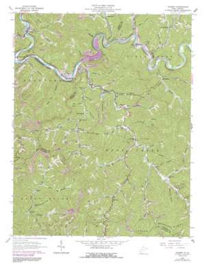
Gilbert Topo Map West Virginia
To zoom in, hover over the map of Gilbert
USGS Topo Quad 37081e7 - 1:24,000 scale
| Topo Map Name: | Gilbert |
| USGS Topo Quad ID: | 37081e7 |
| Print Size: | ca. 21 1/4" wide x 27" high |
| Southeast Coordinates: | 37.5° N latitude / 81.75° W longitude |
| Map Center Coordinates: | 37.5625° N latitude / 81.8125° W longitude |
| U.S. State: | WV |
| Filename: | o37081e7.jpg |
| Download Map JPG Image: | Gilbert topo map 1:24,000 scale |
| Map Type: | Topographic |
| Topo Series: | 7.5´ |
| Map Scale: | 1:24,000 |
| Source of Map Images: | United States Geological Survey (USGS) |
| Alternate Map Versions: |
Gilbert WV 1963, updated 1964 Download PDF Buy paper map Gilbert WV 1963, updated 1978 Download PDF Buy paper map Gilbert WV 1963, updated 1991 Download PDF Buy paper map Gilbert WV 1996, updated 2003 Download PDF Buy paper map Gilbert WV 2011 Download PDF Buy paper map Gilbert WV 2014 Download PDF Buy paper map Gilbert WV 2016 Download PDF Buy paper map |
1:24,000 Topo Quads surrounding Gilbert
Holden |
Logan |
Amherstdale |
Lorado |
Pilot Knob |
Barnabus |
Man |
Mallory |
Oceana |
Matheny |
Majestic |
Wharncliffe |
Gilbert |
Baileysville |
Pineville |
Hurley |
Panther |
Iaeger |
Davy |
Welch |
Grundy |
Patterson |
Bradshaw |
War |
Gary |
> Back to 37081e1 at 1:100,000 scale
> Back to 37080a1 at 1:250,000 scale
> Back to U.S. Topo Maps home
Gilbert topo map: Gazetteer
Gilbert: Capes
Joe Point elevation 387m 1269′Gilbert: Dams
Big Lick Branch Dams Dam elevation 523m 1715′Big Lick Branch Dams Dam elevation 523m 1715′
Big Lick Branch Dams Dam elevation 523m 1715′
Neds Branch Refuse Bank Dam elevation 340m 1115′
R D Bailey Lake Dam elevation 333m 1092′
Gilbert: Populated Places
Big Branch elevation 363m 1190′Cub City elevation 318m 1043′
Gilbert elevation 256m 839′
Hanover elevation 343m 1125′
Ikes Fork elevation 381m 1250′
Justice elevation 272m 892′
Leatherwood elevation 321m 1053′
Long Branch elevation 365m 1197′
Longpole elevation 343m 1125′
North Spring elevation 331m 1085′
Sprattsville elevation 264m 866′
Steeles elevation 341m 1118′
Gilbert: Post Offices
Hanover Post Office elevation 330m 1082′Ikes Fork Post Office elevation 418m 1371′
Justice Post Office elevation 271m 889′
North Spring Post Office elevation 336m 1102′
Gilbert: Reservoirs
R. D. Bailey Lake elevation 333m 1092′Slagle Impoundment elevation 523m 1715′
Gilbert: Streams
Bear Fork elevation 329m 1079′Big Branch elevation 318m 1043′
Big Branch elevation 321m 1053′
Big Cub Creek elevation 321m 1053′
Big Swamp Fork elevation 341m 1118′
Brushy Fork elevation 374m 1227′
Buffalo Creek elevation 336m 1102′
Defeat Branch elevation 353m 1158′
Gap Branch elevation 362m 1187′
Garden Gap Branch elevation 321m 1053′
Gilbert Creek elevation 255m 836′
Groundhog Branch elevation 294m 964′
Harless Fork elevation 375m 1230′
Hickory Branch elevation 318m 1043′
Honey Run elevation 325m 1066′
Ikes Fork elevation 382m 1253′
Kezee Fork elevation 386m 1266′
Leatherwood Creek elevation 318m 1043′
Left Hand Fork Harrys Branch elevation 261m 856′
Little Cub Creek elevation 303m 994′
Little Huff Creek elevation 274m 898′
Little Swamp Fork elevation 340m 1115′
Lizard Creek elevation 311m 1020′
Long Branch elevation 321m 1053′
Lost Branch elevation 279m 915′
Mare Branch elevation 321m 1053′
Mill Branch elevation 321m 1053′
Mudlick Fork elevation 404m 1325′
Muzzle Creek elevation 327m 1072′
Napier Fork elevation 330m 1082′
Neds Branch elevation 257m 843′
Nelson Branch elevation 322m 1056′
North Spring Branch elevation 317m 1040′
Oak Branch elevation 349m 1145′
Panther Fork elevation 336m 1102′
Riffe Branch elevation 358m 1174′
Right Fork Muzzle Creek elevation 342m 1122′
Rock Branch elevation 376m 1233′
Rose Branch elevation 320m 1049′
Salt River elevation 318m 1043′
Stafford Branch elevation 247m 810′
Stafford Trace elevation 318m 1043′
Sugarcamp Fork elevation 370m 1213′
Suke Creek elevation 339m 1112′
Trace Fork elevation 333m 1092′
Trap Branch elevation 339m 1112′
White Oak Branch elevation 278m 912′
Wildcat Creek elevation 334m 1095′
Gilbert: Valleys
Argus Hollow elevation 318m 1043′Big Hollow elevation 371m 1217′
Canebrake Hollow elevation 317m 1040′
Coal Hollow elevation 348m 1141′
Ely Hollow elevation 369m 1210′
Morgan Hollow elevation 364m 1194′
Newsome Hollow elevation 361m 1184′
Old House Hollow elevation 324m 1062′
Rocky Poplar Hollow elevation 349m 1145′
Splashdam Hollow elevation 382m 1253′
Steer Hollow elevation 418m 1371′
Switchback Hollow elevation 415m 1361′
Gilbert digital topo map on disk
Buy this Gilbert topo map showing relief, roads, GPS coordinates and other geographical features, as a high-resolution digital map file on DVD:
Western Virginia & Southern West Virginia
Buy digital topo maps: Western Virginia & Southern West Virginia


