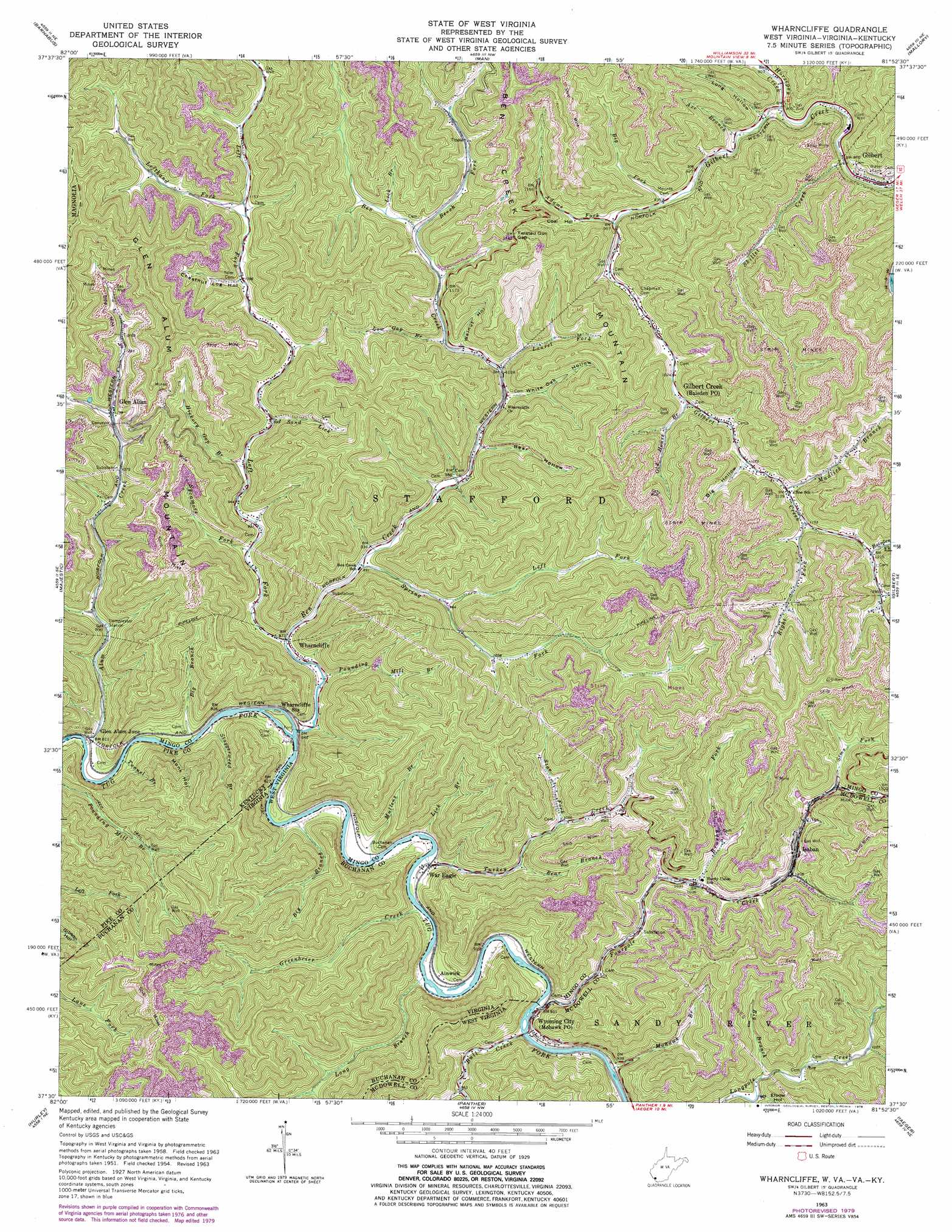
Wharncliffe Topo Map West Virginia
To zoom in, hover over the map of Wharncliffe
USGS Topo Quad 37081e8 - 1:24,000 scale
| Topo Map Name: | Wharncliffe |
| USGS Topo Quad ID: | 37081e8 |
| Print Size: | ca. 21 1/4" wide x 27" high |
| Southeast Coordinates: | 37.5° N latitude / 81.875° W longitude |
| Map Center Coordinates: | 37.5625° N latitude / 81.9375° W longitude |
| U.S. States: | WV, VA, KY |
| Filename: | o37081e8.jpg |
| Download Map JPG Image: | Wharncliffe topo map 1:24,000 scale |
| Map Type: | Topographic |
| Topo Series: | 7.5´ |
| Map Scale: | 1:24,000 |
| Source of Map Images: | United States Geological Survey (USGS) |
| Alternate Map Versions: |
Wharncliffe WV 1954, updated 1955 Download PDF Buy paper map Wharncliffe WV 1963, updated 1966 Download PDF Buy paper map Wharncliffe WV 1963, updated 1976 Download PDF Buy paper map Wharncliffe WV 1963, updated 1979 Download PDF Buy paper map Wharncliffe WV 2001, updated 2003 Download PDF Buy paper map Wharncliffe WV 2011 Download PDF Buy paper map Wharncliffe WV 2014 Download PDF Buy paper map Wharncliffe WV 2016 Download PDF Buy paper map |
1:24,000 Topo Quads surrounding Wharncliffe
Myrtle |
Holden |
Logan |
Amherstdale |
Lorado |
Delbarton |
Barnabus |
Man |
Mallory |
Oceana |
Matewan |
Majestic |
Wharncliffe |
Gilbert |
Baileysville |
Jamboree |
Hurley |
Panther |
Iaeger |
Davy |
Harman |
Grundy |
Patterson |
Bradshaw |
War |
> Back to 37081e1 at 1:100,000 scale
> Back to 37080a1 at 1:250,000 scale
> Back to U.S. Topo Maps home
Wharncliffe topo map: Gazetteer
Wharncliffe: Gaps
Twisted Gun Gap elevation 449m 1473′Wharncliffe: Populated Places
Baisden elevation 317m 1040′Gilbert Creek elevation 337m 1105′
Glen Alum elevation 355m 1164′
Glen Alum Junction elevation 248m 813′
Horsepen (historical) elevation 271m 889′
Isaban elevation 348m 1141′
Mohawk elevation 308m 1010′
War Eagle elevation 265m 869′
Wharncliffe elevation 259m 849′
Wyoming City elevation 283m 928′
Wharncliffe: Post Offices
Baisden Post Office elevation 317m 1040′Isaban Post Office elevation 346m 1135′
Wharncliffe Post Office elevation 261m 856′
Wharncliffe: Streams
Adams Fork elevation 298m 977′Alum Creek elevation 238m 780′
Axe Branch elevation 274m 898′
Baisden Fork elevation 371m 1217′
Bear Branch elevation 294m 964′
Bear Fork elevation 296m 971′
Beech Fork elevation 351m 1151′
Ben Creek elevation 247m 810′
Big Branch elevation 303m 994′
Big Branch elevation 243m 797′
Big Branch elevation 250m 820′
Big Fork elevation 293m 961′
Brushy Fork elevation 312m 1023′
Buck Branch elevation 285m 935′
Bull Creek elevation 274m 898′
Fourpole Creek elevation 273m 895′
Greenbrier Creek elevation 264m 866′
Hickory Gap Branch elevation 300m 984′
Horsepen Creek elevation 271m 889′
Laurel Fork elevation 312m 1023′
Left Fork Alum Creek elevation 284m 931′
Left Fork Ben Creek elevation 257m 843′
Left Fork Gilbert Creek elevation 350m 1148′
Left Fork Spring Fork elevation 291m 954′
Lefthand Left Fork Ben Creek elevation 345m 1131′
Lick Branch elevation 259m 849′
Lick Branch elevation 350m 1148′
Long Branch elevation 270m 885′
Low Gap Branch elevation 320m 1049′
Lower Pete Branch elevation 274m 898′
Mohawk Branch elevation 275m 902′
Mudlick Branch elevation 344m 1128′
Mullens Branch elevation 254m 833′
Old House Branch elevation 316m 1036′
Pickering Branch elevation 384m 1259′
Pound Mill Branch elevation 291m 954′
Pounding Mill Branch elevation 251m 823′
Right Fork Gilbert Creek elevation 351m 1151′
Righthand Fork elevation 298m 977′
Rough Branch elevation 289m 948′
Sand Lick elevation 307m 1007′
Sims Fork elevation 364m 1194′
Skillet Creek elevation 271m 889′
Spring Fork elevation 271m 889′
Staggerweed Branch elevation 241m 790′
Star Fork elevation 319m 1046′
Sycamore Fork elevation 277m 908′
Tunnel Branch elevation 240m 787′
Turkey Creek elevation 259m 849′
Wharncliffe: Summits
Ben Creek Mountain elevation 630m 2066′Glen Alum Mountain elevation 660m 2165′
Wharncliffe: Valleys
Bear Hollow elevation 304m 997′Big Hollow elevation 337m 1105′
Chestnut Log Hollow elevation 339m 1112′
Coal Hollow elevation 313m 1026′
Elbow Hollow elevation 306m 1003′
Long Hollow elevation 277m 908′
Monk Hollow elevation 250m 820′
North Hollow elevation 296m 971′
Trent Hollow elevation 264m 866′
Walnut Hollow elevation 327m 1072′
White Oak Hollow elevation 309m 1013′
Wharncliffe digital topo map on disk
Buy this Wharncliffe topo map showing relief, roads, GPS coordinates and other geographical features, as a high-resolution digital map file on DVD:
Western Virginia & Southern West Virginia
Buy digital topo maps: Western Virginia & Southern West Virginia