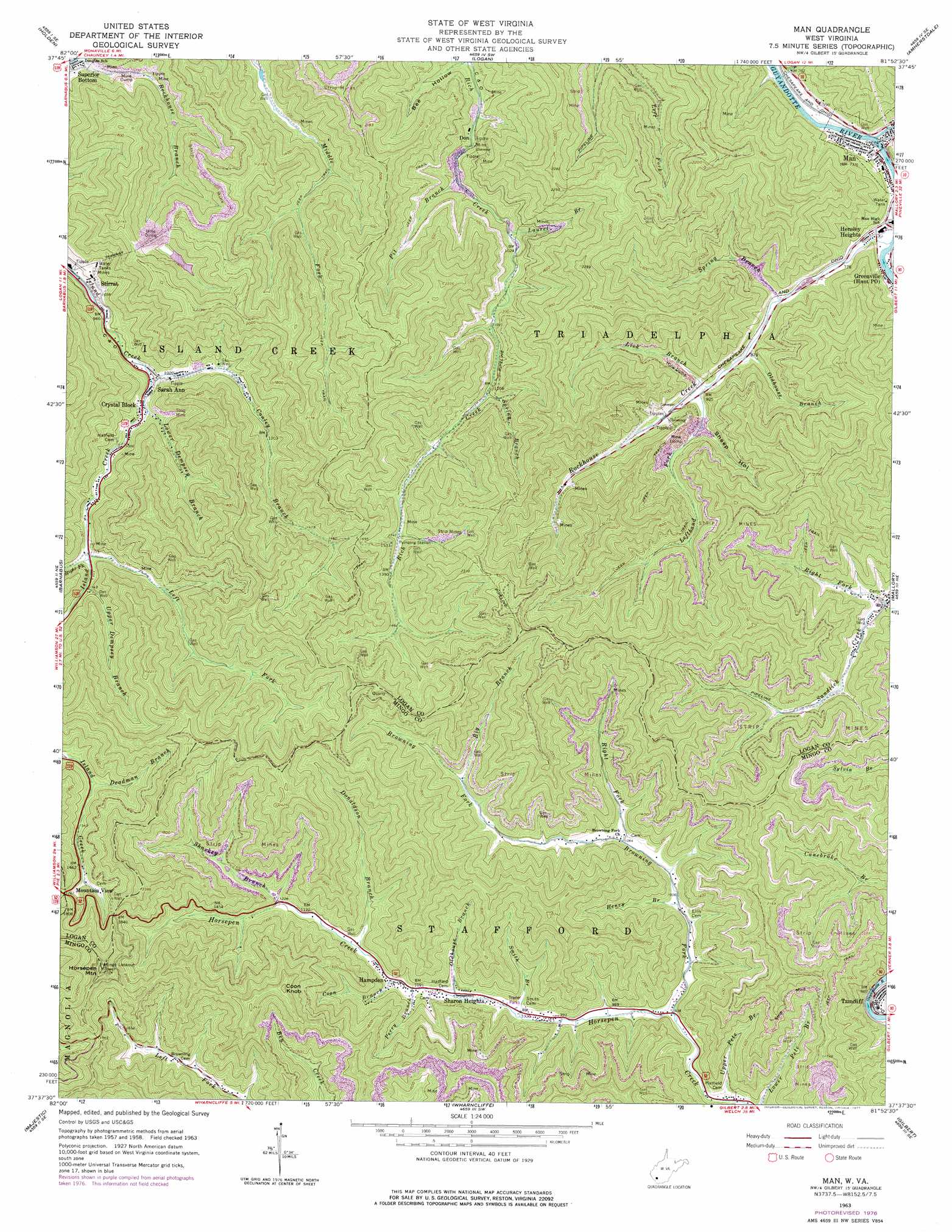
Man Topo Map West Virginia
To zoom in, hover over the map of Man
USGS Topo Quad 37081f8 - 1:24,000 scale
| Topo Map Name: | Man |
| USGS Topo Quad ID: | 37081f8 |
| Print Size: | ca. 21 1/4" wide x 27" high |
| Southeast Coordinates: | 37.625° N latitude / 81.875° W longitude |
| Map Center Coordinates: | 37.6875° N latitude / 81.9375° W longitude |
| U.S. State: | WV |
| Filename: | o37081f8.jpg |
| Download Map JPG Image: | Man topo map 1:24,000 scale |
| Map Type: | Topographic |
| Topo Series: | 7.5´ |
| Map Scale: | 1:24,000 |
| Source of Map Images: | United States Geological Survey (USGS) |
| Alternate Map Versions: |
Man WV 1963, updated 1965 Download PDF Buy paper map Man WV 1963, updated 1974 Download PDF Buy paper map Man WV 1963, updated 1977 Download PDF Buy paper map Man WV 1996, updated 2003 Download PDF Buy paper map Man WV 2011 Download PDF Buy paper map Man WV 2014 Download PDF Buy paper map Man WV 2016 Download PDF Buy paper map |
1:24,000 Topo Quads surrounding Man
Trace |
Chapmanville |
Henlawson |
Clothier |
Wharton |
Myrtle |
Holden |
Logan |
Amherstdale |
Lorado |
Delbarton |
Barnabus |
Man |
Mallory |
Oceana |
Matewan |
Majestic |
Wharncliffe |
Gilbert |
Baileysville |
Jamboree |
Hurley |
Panther |
Iaeger |
Davy |
> Back to 37081e1 at 1:100,000 scale
> Back to 37080a1 at 1:250,000 scale
> Back to U.S. Topo Maps home
Man topo map: Gazetteer
Man: Dams
Stirrat Number 15 Waste Embankment Dam elevation 564m 1850′Man: Populated Places
Crystal Block elevation 310m 1017′Don elevation 270m 885′
Hampden elevation 333m 1092′
Hensley Heights elevation 231m 757′
Man elevation 225m 738′
Sarah Ann elevation 304m 997′
Sharon Heights elevation 318m 1043′
Superior Bottom elevation 256m 839′
Tamcliff elevation 247m 810′
Man: Post Offices
Hampden Post Office elevation 324m 1062′Man: Reservoirs
Stirrat Number 15 Impoundment elevation 564m 1850′Man: Streams
Big Branch elevation 391m 1282′Browning Fork elevation 286m 938′
Buffalo Creek elevation 225m 738′
Conley Branch elevation 299m 980′
Coon Branch elevation 337m 1105′
Deadman Branch elevation 446m 1463′
Donaldson Branch elevation 348m 1141′
Henry Branch elevation 303m 994′
Laurel Branch elevation 305m 1000′
Left Fork elevation 338m 1108′
Lefthand Fork elevation 280m 918′
Lick Branch elevation 294m 964′
Lower Dempsey Branch elevation 315m 1033′
Oldhouse Branch elevation 267m 875′
Oldhouse Branch elevation 319m 1046′
Perry Branch elevation 332m 1089′
Pit Branch elevation 283m 928′
Right Fork Browning Fork elevation 323m 1059′
Right Fork Island Creek elevation 341m 1118′
Right Fork Sandlick Creek elevation 243m 797′
Road Fork elevation 307m 1007′
Rockhouse Branch elevation 307m 1007′
Rockhouse Creek elevation 221m 725′
Sharkey Branch elevation 374m 1227′
Smith Branch elevation 308m 1010′
Spring Branch elevation 355m 1164′
Spring Branch elevation 250m 820′
Upper Dempsey Branch elevation 346m 1135′
Upper Pete Branch elevation 276m 905′
Man: Summits
Coon Knob elevation 742m 2434′Horsepen Mountain elevation 763m 2503′
Man: Valleys
Sheep Hollow elevation 302m 990′Man digital topo map on disk
Buy this Man topo map showing relief, roads, GPS coordinates and other geographical features, as a high-resolution digital map file on DVD:
Western Virginia & Southern West Virginia
Buy digital topo maps: Western Virginia & Southern West Virginia