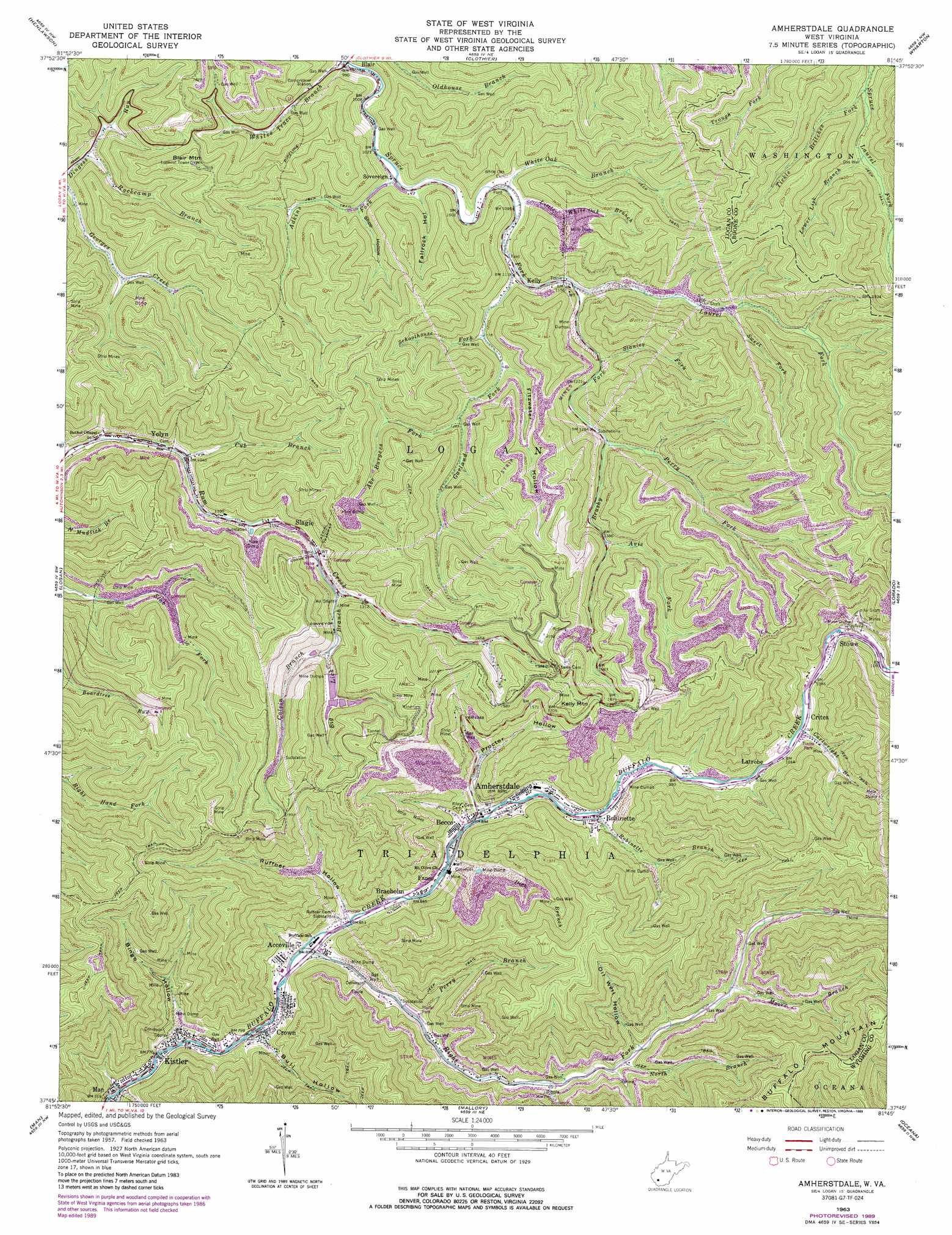
Amherstdale Topo Map West Virginia
To zoom in, hover over the map of Amherstdale
USGS Topo Quad 37081g7 - 1:24,000 scale
| Topo Map Name: | Amherstdale |
| USGS Topo Quad ID: | 37081g7 |
| Print Size: | ca. 21 1/4" wide x 27" high |
| Southeast Coordinates: | 37.75° N latitude / 81.75° W longitude |
| Map Center Coordinates: | 37.8125° N latitude / 81.8125° W longitude |
| U.S. State: | WV |
| Filename: | o37081g7.jpg |
| Download Map JPG Image: | Amherstdale topo map 1:24,000 scale |
| Map Type: | Topographic |
| Topo Series: | 7.5´ |
| Map Scale: | 1:24,000 |
| Source of Map Images: | United States Geological Survey (USGS) |
| Alternate Map Versions: |
Amherstdale WV 1963, updated 1964 Download PDF Buy paper map Amherstdale WV 1963, updated 1973 Download PDF Buy paper map Amherstdale WV 1963, updated 1978 Download PDF Buy paper map Amherstdale WV 1963, updated 1989 Download PDF Buy paper map Amherstdale WV 1996, updated 2002 Download PDF Buy paper map Amherstdale WV 2011 Download PDF Buy paper map Amherstdale WV 2014 Download PDF Buy paper map Amherstdale WV 2016 Download PDF Buy paper map |
1:24,000 Topo Quads surrounding Amherstdale
Big Creek |
Mud |
Madison |
Williams Mountain |
Sylvester |
Chapmanville |
Henlawson |
Clothier |
Wharton |
Whitesville |
Holden |
Logan |
Amherstdale |
Lorado |
Pilot Knob |
Barnabus |
Man |
Mallory |
Oceana |
Matheny |
Majestic |
Wharncliffe |
Gilbert |
Baileysville |
Pineville |
> Back to 37081e1 at 1:100,000 scale
> Back to 37080a1 at 1:250,000 scale
> Back to U.S. Topo Maps home
Amherstdale topo map: Gazetteer
Amherstdale: Dams
Titanic Hollow Dam elevation 464m 1522′Amherstdale: Populated Places
Accoville elevation 254m 833′Amherstdale elevation 273m 895′
Becco elevation 271m 889′
Braeholm elevation 263m 862′
Crites elevation 316m 1036′
Crown elevation 248m 813′
Fanco elevation 265m 869′
Kelly elevation 343m 1125′
Kistler elevation 236m 774′
Latrobe elevation 308m 1010′
Robinette elevation 287m 941′
Slagle elevation 369m 1210′
Sovereign elevation 314m 1030′
Stowe elevation 323m 1059′
Yolyn elevation 306m 1003′
Amherstdale: Post Offices
Amherstdale Post Office elevation 275m 902′Crown Post Office elevation 247m 810′
Robinette Post Office elevation 287m 941′
Yolyn Post Office elevation 297m 974′
Amherstdale: Reservoirs
Rum Creek Impoundment elevation 464m 1522′Amherstdale: Streams
Abe Burgess Fork elevation 402m 1318′Adkins Fork elevation 314m 1030′
Avis Fork elevation 422m 1384′
Big Lick Branch elevation 403m 1322′
Brushy Fork elevation 351m 1151′
Calvin Branch elevation 413m 1354′
Cartwright Branch elevation 324m 1062′
Cub Branch elevation 316m 1036′
Dick Branch elevation 377m 1236′
Garland Fork elevation 341m 1118′
Laurel Fork elevation 351m 1151′
Little White Oak Branch elevation 341m 1118′
Lower Lick Branch elevation 372m 1220′
Moore Branch elevation 377m 1236′
Mudlick Branch elevation 271m 889′
North Branch elevation 341m 1118′
Perry Branch elevation 279m 915′
Perry Fork elevation 388m 1272′
Right Fork Buffalo Creek elevation 258m 846′
Robinette Branch elevation 287m 941′
Rockcamp Branch elevation 325m 1066′
Schoolhouse Fork elevation 358m 1174′
Stanley Fork elevation 365m 1197′
Sweet Fork elevation 390m 1279′
Tickle Britches Fork elevation 361m 1184′
White Oak Branch elevation 331m 1085′
Whites Trace Branch elevation 302m 990′
Amherstdale: Summits
Blair Mountain elevation 596m 1955′Kelly Mountain elevation 661m 2168′
Amherstdale: Valleys
Bingo Hollow elevation 235m 770′Bull Hollow elevation 242m 793′
Fallrock Hollow elevation 312m 1023′
Fitzwater Hollow elevation 372m 1220′
Oil Well Hollow elevation 348m 1141′
Proctor Hollow elevation 272m 892′
Ruffner Hollow elevation 258m 846′
Shop Hollow elevation 347m 1138′
Amherstdale digital topo map on disk
Buy this Amherstdale topo map showing relief, roads, GPS coordinates and other geographical features, as a high-resolution digital map file on DVD:
Western Virginia & Southern West Virginia
Buy digital topo maps: Western Virginia & Southern West Virginia