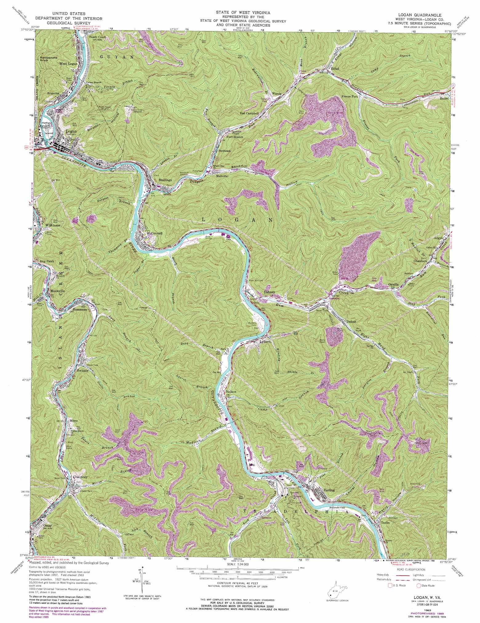
Logan Topo Map West Virginia
To zoom in, hover over the map of Logan
USGS Topo Quad 37081g8 - 1:24,000 scale
| Topo Map Name: | Logan |
| USGS Topo Quad ID: | 37081g8 |
| Print Size: | ca. 21 1/4" wide x 27" high |
| Southeast Coordinates: | 37.75° N latitude / 81.875° W longitude |
| Map Center Coordinates: | 37.8125° N latitude / 81.9375° W longitude |
| U.S. State: | WV |
| Filename: | o37081g8.jpg |
| Download Map JPG Image: | Logan topo map 1:24,000 scale |
| Map Type: | Topographic |
| Topo Series: | 7.5´ |
| Map Scale: | 1:24,000 |
| Source of Map Images: | United States Geological Survey (USGS) |
| Alternate Map Versions: |
Logan WV 1963, updated 1964 Download PDF Buy paper map Logan WV 1963, updated 1973 Download PDF Buy paper map Logan WV 1963, updated 1977 Download PDF Buy paper map Logan WV 1963, updated 1989 Download PDF Buy paper map Logan WV 1996, updated 2002 Download PDF Buy paper map Logan WV 2011 Download PDF Buy paper map Logan WV 2014 Download PDF Buy paper map Logan WV 2016 Download PDF Buy paper map |
1:24,000 Topo Quads surrounding Logan
Ranger |
Big Creek |
Mud |
Madison |
Williams Mountain |
Trace |
Chapmanville |
Henlawson |
Clothier |
Wharton |
Myrtle |
Holden |
Logan |
Amherstdale |
Lorado |
Delbarton |
Barnabus |
Man |
Mallory |
Oceana |
Matewan |
Majestic |
Wharncliffe |
Gilbert |
Baileysville |
> Back to 37081e1 at 1:100,000 scale
> Back to 37080a1 at 1:250,000 scale
> Back to U.S. Topo Maps home
Logan topo map: Gazetteer
Logan: Airports
McDonald Field elevation 220m 721′Logan: Bridges
Jeep Bridge elevation 202m 662′Logan: Islands
Hatfield Island elevation 205m 672′Logan: Populated Places
Aracoma elevation 209m 685′Argyle elevation 281m 921′
Buskirk Addition elevation 226m 741′
Chambers elevation 272m 892′
Chauncey elevation 242m 793′
Dabney elevation 218m 715′
Dehue elevation 247m 810′
Deskin Addition elevation 220m 721′
Dog Patch elevation 209m 685′
Earling elevation 224m 734′
Ethel elevation 251m 823′
Fort Branch elevation 220m 721′
Freeze Fork elevation 265m 869′
Hetzel elevation 308m 1010′
Hutchinson elevation 274m 898′
Logan elevation 207m 679′
Lyburn elevation 216m 708′
McConnell elevation 214m 702′
Mellville elevation 219m 718′
Micco elevation 237m 777′
Monaville elevation 217m 711′
Neibert elevation 219m 718′
Omar elevation 248m 813′
Orville elevation 253m 830′
Peach Creek elevation 205m 672′
Red Campbell elevation 229m 751′
Rita elevation 220m 721′
Rossmore elevation 222m 728′
Rum Junction elevation 209m 685′
Stollings elevation 205m 672′
Sunbeam elevation 215m 705′
Switzer elevation 227m 744′
Taplin elevation 223m 731′
Wanda elevation 234m 767′
West Logan elevation 207m 679′
Wilkinson elevation 208m 682′
Logan: Post Offices
Dehue Post Office elevation 230m 754′Logan Post Office elevation 208m 682′
Lyburn Post Office elevation 215m 705′
McConnell Post Office elevation 213m 698′
Peach Creek Post Office elevation 207m 679′
Stollings Post Office elevation 207m 679′
Taplin Post Office elevation 224m 734′
West Logan Post Office elevation 206m 675′
Logan: Springs
Triadelphia Water-Taplin Spring elevation 437m 1433′Logan: Streams
Bearwallow Branch elevation 235m 770′Beech Branch elevation 203m 666′
Boardtree Run elevation 278m 912′
Burgess Branch elevation 278m 912′
Burgess Branch elevation 201m 659′
Camp Branch elevation 257m 843′
Camp Branch elevation 208m 682′
Coal Branch elevation 211m 692′
Davy Branch elevation 206m 675′
Dingess Run elevation 200m 656′
Fort Branch elevation 220m 721′
Freeze Fork elevation 264m 866′
Georges Creek elevation 310m 1017′
Island Creek elevation 203m 666′
Laurel Branch elevation 213m 698′
Lawson Branch elevation 198m 649′
Left Fork Rich Creek elevation 225m 738′
Lick Branch elevation 279m 915′
Lynn Branch elevation 220m 721′
Madison Branch elevation 208m 682′
Mash Branch elevation 249m 816′
Middle Fork Island Creek elevation 240m 787′
Mill Creek elevation 219m 718′
Miller Branch elevation 240m 787′
North Mudlick Branch elevation 270m 885′
Peach Creek elevation 197m 646′
Peters Branch elevation 234m 767′
Pine Branch elevation 213m 698′
Rich Creek elevation 214m 702′
Right Hand Fork Rum Creek elevation 228m 748′
Rockhouse Branch elevation 251m 823′
Rum Creek elevation 204m 669′
Slab Fork elevation 251m 823′
South Mudlick Branch elevation 274m 898′
Steele Branch elevation 223m 731′
Sugar Branch elevation 209m 685′
Thompson Branch elevation 204m 669′
Varney Branch elevation 198m 649′
Winding Shoals Branch elevation 209m 685′
Logan: Summits
Rattlesnake Knob elevation 602m 1975′Logan: Valleys
Bandmill Hollow elevation 213m 698′Bee Hollow elevation 255m 836′
Ethel Hollow elevation 248m 813′
Henry Hollow elevation 217m 711′
Laurel Hollow elevation 215m 705′
Stratton Hollow elevation 208m 682′
Logan digital topo map on disk
Buy this Logan topo map showing relief, roads, GPS coordinates and other geographical features, as a high-resolution digital map file on DVD:
Western Virginia & Southern West Virginia
Buy digital topo maps: Western Virginia & Southern West Virginia