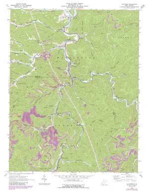
Clothier Topo Map West Virginia
To zoom in, hover over the map of Clothier
USGS Topo Quad 37081h7 - 1:24,000 scale
| Topo Map Name: | Clothier |
| USGS Topo Quad ID: | 37081h7 |
| Print Size: | ca. 21 1/4" wide x 27" high |
| Southeast Coordinates: | 37.875° N latitude / 81.75° W longitude |
| Map Center Coordinates: | 37.9375° N latitude / 81.8125° W longitude |
| U.S. State: | WV |
| Filename: | o37081h7.jpg |
| Download Map JPG Image: | Clothier topo map 1:24,000 scale |
| Map Type: | Topographic |
| Topo Series: | 7.5´ |
| Map Scale: | 1:24,000 |
| Source of Map Images: | United States Geological Survey (USGS) |
| Alternate Map Versions: |
Clothier WV 1963, updated 1964 Download PDF Buy paper map Clothier WV 1963, updated 1977 Download PDF Buy paper map Clothier WV 1963, updated 1989 Download PDF Buy paper map Clothier WV 1996, updated 2002 Download PDF Buy paper map Clothier WV 2011 Download PDF Buy paper map Clothier WV 2014 Download PDF Buy paper map Clothier WV 2016 Download PDF Buy paper map |
1:24,000 Topo Quads surrounding Clothier
> Back to 37081e1 at 1:100,000 scale
> Back to 37080a1 at 1:250,000 scale
> Back to U.S. Topo Maps home
Clothier topo map: Gazetteer
Clothier: Populated Places
Blair elevation 296m 971′Clothier elevation 246m 807′
Coal Valley elevation 248m 813′
Dobra elevation 252m 826′
Five Block elevation 287m 941′
Greenview elevation 231m 757′
Havana elevation 266m 872′
Hewett elevation 249m 816′
Isom elevation 269m 882′
Jeffrey elevation 239m 784′
Mifflin elevation 249m 816′
Monclo elevation 279m 915′
Ottawa elevation 240m 787′
Ramage elevation 247m 810′
Secoal elevation 232m 761′
Sharples elevation 257m 843′
Sodom elevation 264m 866′
Spruce Valley elevation 293m 961′
Clothier: Post Offices
Blair Post Office elevation 301m 987′Hewett Post Office elevation 249m 816′
Ramage Post Office elevation 232m 761′
Sharples Post Office elevation 259m 849′
Clothier: Streams
Beech Creek elevation 255m 836′Bend Branch elevation 246m 807′
Bias Branch elevation 231m 757′
Big Branch elevation 227m 744′
Burnt Cabin Branch elevation 261m 856′
Chestnut Camp Branch elevation 313m 1026′
Coal Branch elevation 236m 774′
Hewett Creek elevation 236m 774′
Hurricane Branch elevation 261m 856′
Laurel Branch elevation 255m 836′
Left Fork Beech Creek elevation 277m 908′
Left Fork Bias Branch elevation 241m 790′
Lick Branch elevation 364m 1194′
Meadow Fork elevation 248m 813′
Mikes Fork elevation 258m 846′
Missouri Fork elevation 250m 820′
Obes Branch elevation 238m 780′
Oldhouse Branch elevation 297m 974′
Pigeonroost Branch elevation 290m 951′
Pigtail Branch elevation 269m 882′
Powell Branch elevation 228m 748′
Right Fork Seng Camp Creek elevation 306m 1003′
Rockhouse Creek elevation 248m 813′
Sandford Branch elevation 270m 885′
Seng Camp Creek elevation 268m 879′
Sixmile Creek elevation 233m 764′
Spruce Laurel Fork elevation 241m 790′
Stollings Branch elevation 239m 784′
Tan Trough Branch elevation 236m 774′
Trace Branch elevation 296m 971′
Trace Branch elevation 264m 866′
Trough Fork elevation 348m 1141′
White Oak Branch elevation 291m 954′
Clothier: Summits
Brushy Point elevation 545m 1788′Clothier: Valleys
Daniel Hollow elevation 290m 951′Indian Grave Hollow elevation 346m 1135′
Clothier digital topo map on disk
Buy this Clothier topo map showing relief, roads, GPS coordinates and other geographical features, as a high-resolution digital map file on DVD:
Western Virginia & Southern West Virginia
Buy digital topo maps: Western Virginia & Southern West Virginia


