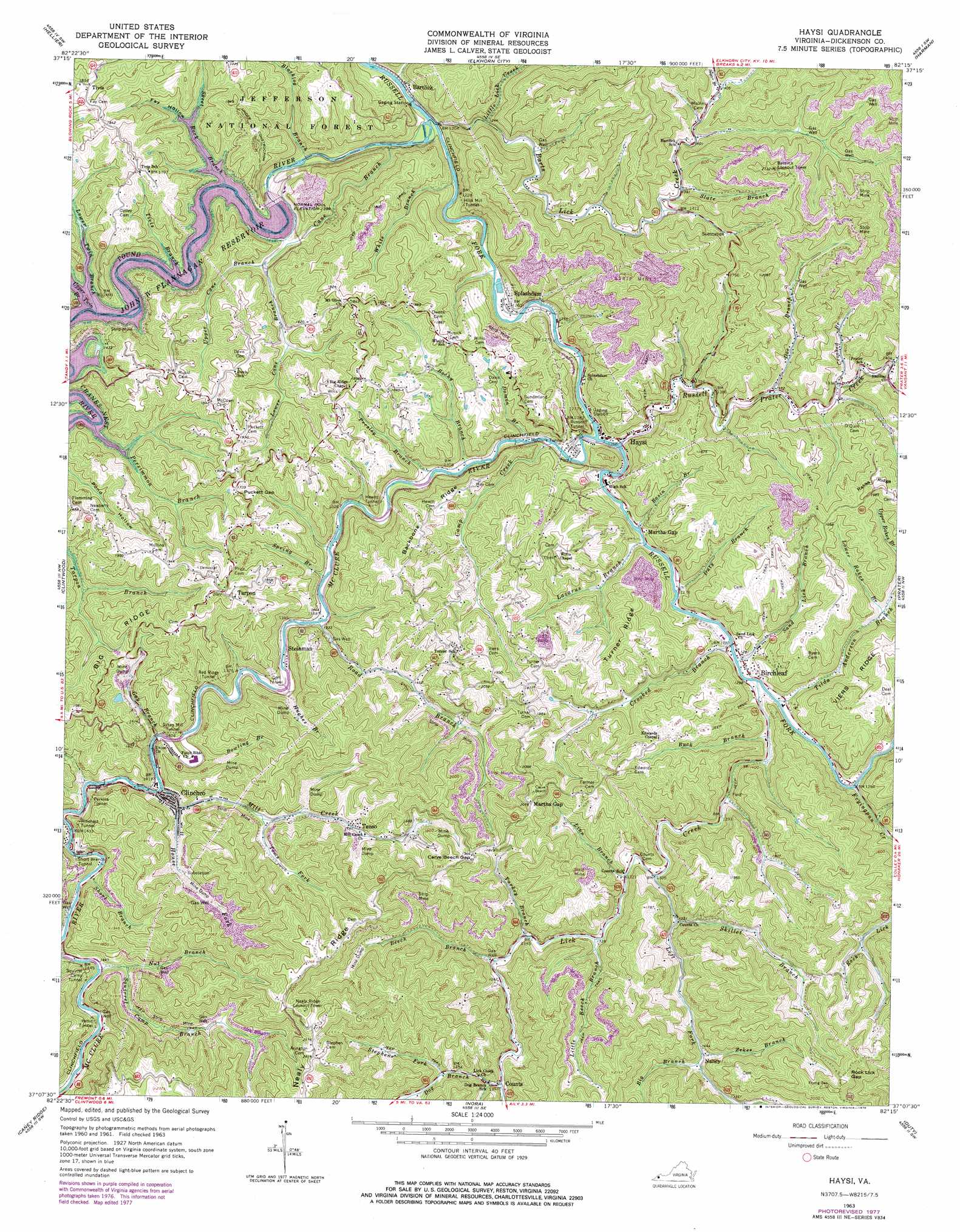
Haysi Topo Map Virginia
To zoom in, hover over the map of Haysi
USGS Topo Quad 37082b3 - 1:24,000 scale
| Topo Map Name: | Haysi |
| USGS Topo Quad ID: | 37082b3 |
| Print Size: | ca. 21 1/4" wide x 27" high |
| Southeast Coordinates: | 37.125° N latitude / 82.25° W longitude |
| Map Center Coordinates: | 37.1875° N latitude / 82.3125° W longitude |
| U.S. State: | VA |
| Filename: | o37082b3.jpg |
| Download Map JPG Image: | Haysi topo map 1:24,000 scale |
| Map Type: | Topographic |
| Topo Series: | 7.5´ |
| Map Scale: | 1:24,000 |
| Source of Map Images: | United States Geological Survey (USGS) |
| Alternate Map Versions: |
Haysi VA 1963, updated 1964 Download PDF Buy paper map Haysi VA 1963, updated 1978 Download PDF Buy paper map Haysi VA 2011 Download PDF Buy paper map Haysi VA 2013 Download PDF Buy paper map Haysi VA 2016 Download PDF Buy paper map |
| FStopo: | US Forest Service topo Haysi is available: Download FStopo PDF Download FStopo TIF |
1:24,000 Topo Quads surrounding Haysi
Pikeville |
Millard |
Lick Creek |
Jamboree |
Hurley |
Dorton |
Hellier |
Elkhorn City |
Harman |
Grundy |
Jenkins East |
Clintwood |
Haysi |
Prater |
Vansant |
Pound |
Caney Ridge |
Nora |
Duty |
Big A Mountain |
Wise |
Coeburn |
Saint Paul |
Carbo |
Lebanon |
> Back to 37082a1 at 1:100,000 scale
> Back to 37082a1 at 1:250,000 scale
> Back to U.S. Topo Maps home
Haysi topo map: Gazetteer
Haysi: Dams
John W Flannagan Dam elevation 373m 1223′Haysi: Gaps
Carve Beech Gap elevation 596m 1955′Martha Gap elevation 638m 2093′
Puckett Gap elevation 531m 1742′
Rock Lick Gap elevation 671m 2201′
Haysi: Populated Places
Bartlick elevation 370m 1213′Birchleaf elevation 396m 1299′
Clinchco elevation 426m 1397′
Delano elevation 600m 1968′
Haysi elevation 387m 1269′
Mart elevation 398m 1305′
Nancy elevation 452m 1482′
Steinman elevation 413m 1354′
Tarpon elevation 616m 2020′
Tenso elevation 474m 1555′
Tivis elevation 576m 1889′
Haysi: Reservoirs
John W. Flannagan Reservoir elevation 373m 1223′Haysi: Ridges
Backbone Ridge elevation 560m 1837′Nealy Ridge elevation 659m 2162′
Turner Ridge elevation 573m 1879′
Haysi: Streams
Barts Lick Creek elevation 357m 1171′Basin Branch elevation 394m 1292′
Beech Branch elevation 417m 1368′
Big Branch elevation 444m 1456′
Blacklog Branch elevation 365m 1197′
Bowling Branch elevation 421m 1381′
Buck Branch elevation 386m 1266′
Camp Branch elevation 426m 1397′
Cane Branch elevation 364m 1194′
Crooked Branch elevation 385m 1263′
Crooked Branch elevation 420m 1377′
Damon Branch elevation 386m 1266′
Doe Branch elevation 415m 1361′
Dog Branch elevation 426m 1397′
Duty Branch elevation 385m 1263′
Fryingpan Creek elevation 387m 1269′
Gay Branch elevation 428m 1404′
House Fork elevation 427m 1400′
Hughes Branch elevation 415m 1361′
Hurricane Branch elevation 386m 1266′
Laurel Branch elevation 431m 1414′
Lazarus Branch elevation 387m 1269′
Left Fork Lick Creek elevation 399m 1309′
Lick Creek elevation 389m 1276′
Linn Branch elevation 419m 1374′
Little Beech Branch elevation 406m 1332′
Little Lick Creek elevation 376m 1233′
Lower Cane Branch elevation 436m 1430′
Lower Rakes Branch elevation 440m 1443′
Lower Twin Branch elevation 425m 1394′
McClure River elevation 382m 1253′
Mill Creek elevation 427m 1400′
Nut Branch elevation 434m 1423′
Persimmon Branch elevation 425m 1394′
Pound River elevation 359m 1177′
Presley Branch elevation 391m 1282′
Road Branch elevation 406m 1332′
Rocky Branch elevation 389m 1276′
Russell Prater Creek elevation 385m 1263′
Sand Lick Branch elevation 389m 1276′
Short Branch elevation 434m 1423′
Skeet Rock Branch elevation 425m 1394′
Skillet Branch elevation 412m 1351′
Slate Branch elevation 423m 1387′
Spring Branch elevation 401m 1315′
Squirrel Camp Branch elevation 450m 1476′
Stephens Fork elevation 461m 1512′
Sugar Branch elevation 428m 1404′
Tilda Anderson Branch elevation 384m 1259′
Tivis Branch elevation 425m 1394′
Toms Fork elevation 426m 1397′
Turkey Branch elevation 411m 1348′
Upper Cane Branch elevation 437m 1433′
Upper Hurricane Branch elevation 390m 1279′
Upper Twin Branch elevation 425m 1394′
White Branch elevation 361m 1184′
Wolfpen Branch elevation 432m 1417′
Zekes Branch elevation 439m 1440′
Haysi: Tunnels
Goff Tunnel elevation 413m 1354′Hewitt Tunnel elevation 539m 1768′
Hills Mill Tunnel elevation 445m 1459′
McClure Tunnel elevation 415m 1361′
Perkins Tunnel elevation 496m 1627′
Pettit Tunnel elevation 434m 1423′
Red Ridge Tunnel elevation 512m 1679′
Rinehart Tunnel elevation 501m 1643′
Russell Tunnel elevation 422m 1384′
Short Branch Tunnel elevation 509m 1669′
Squirrel Camp Tunnel elevation 474m 1555′
Sykes Mill Tunnel elevation 466m 1528′
Haysi: Valleys
Fay Hollow elevation 425m 1394′Haysi digital topo map on disk
Buy this Haysi topo map showing relief, roads, GPS coordinates and other geographical features, as a high-resolution digital map file on DVD:
Western Virginia & Southern West Virginia
Buy digital topo maps: Western Virginia & Southern West Virginia