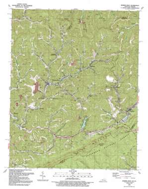
Jenkins West Topo Map Kentucky
To zoom in, hover over the map of Jenkins West
USGS Topo Quad 37082b6 - 1:24,000 scale
| Topo Map Name: | Jenkins West |
| USGS Topo Quad ID: | 37082b6 |
| Print Size: | ca. 21 1/4" wide x 27" high |
| Southeast Coordinates: | 37.125° N latitude / 82.625° W longitude |
| Map Center Coordinates: | 37.1875° N latitude / 82.6875° W longitude |
| U.S. States: | KY, VA |
| Filename: | o37082b6.jpg |
| Download Map JPG Image: | Jenkins West topo map 1:24,000 scale |
| Map Type: | Topographic |
| Topo Series: | 7.5´ |
| Map Scale: | 1:24,000 |
| Source of Map Images: | United States Geological Survey (USGS) |
| Alternate Map Versions: |
Jenkins West KY 1954, updated 1956 Download PDF Buy paper map Jenkins West KY 1954, updated 1967 Download PDF Buy paper map Jenkins West KY 1954, updated 1979 Download PDF Buy paper map Jenkins West KY 1992, updated 1992 Download PDF Buy paper map Jenkins West KY 2011 Download PDF Buy paper map Jenkins West KY 2013 Download PDF Buy paper map Jenkins West KY 2016 Download PDF Buy paper map |
| FStopo: | US Forest Service topo Jenkins West is available: Download FStopo PDF Download FStopo TIF |
1:24,000 Topo Quads surrounding Jenkins West
> Back to 37082a1 at 1:100,000 scale
> Back to 37082a1 at 1:250,000 scale
> Back to U.S. Topo Maps home
Jenkins West topo map: Gazetteer
Jenkins West: Dams
North Fork of Pound Dam elevation 490m 1607′Jenkins West: Flats
Bandmill Bottom elevation 438m 1437′Jenkins West: Gaps
Boone Gap elevation 603m 1978′Indian Grave Gap elevation 795m 2608′
Indian Grave Gap elevation 785m 2575′
Potter Gap elevation 516m 1692′
Potters Gap elevation 513m 1683′
Pound Gap elevation 729m 2391′
Jenkins West: Lakes
Fishpond Lake elevation 464m 1522′Jenkins West: Populated Places
Beefhide elevation 370m 1213′Bottom Fork elevation 407m 1335′
Cromona elevation 406m 1332′
Dunham elevation 486m 1594′
Fleming elevation 404m 1325′
Fleming-Neon elevation 424m 1391′
Haymond elevation 436m 1430′
Hemphill elevation 419m 1374′
Jenkins elevation 469m 1538′
Kona elevation 384m 1259′
McRoberts elevation 436m 1430′
Neon elevation 396m 1299′
Neon Junction elevation 387m 1269′
Payne Gap elevation 538m 1765′
Potters Fork elevation 436m 1430′
Seco elevation 384m 1259′
Tolliver Town elevation 398m 1305′
Whitaker elevation 390m 1279′
Jenkins West: Post Offices
Baker Post Office (historical) elevation 423m 1387′Beefhide Post Office (historical) elevation 388m 1272′
Bentley Post Office (historical) elevation 571m 1873′
Bilvia Post Office (historical) elevation 454m 1489′
Chip Post Office (historical) elevation 408m 1338′
Craftsville Post Office (historical) elevation 415m 1361′
Cromona Post Office elevation 410m 1345′
Cumming Post Office (historical) elevation 410m 1345′
Dunham Post Office (historical) elevation 489m 1604′
Fishpond Post Office (historical) elevation 439m 1440′
Fleming Post Office (historical) elevation 406m 1332′
Horn Post Office (historical) elevation 415m 1361′
Jenkins Post Office elevation 471m 1545′
Kona Post Office (historical) elevation 398m 1305′
Lima Post Office (historical) elevation 444m 1456′
McRoberts Post Office elevation 453m 1486′
Moss Post Office (historical) elevation 501m 1643′
Neon Post Office (historical) elevation 393m 1289′
Payne Gap Post Office (historical) elevation 552m 1811′
Potters Fork Post Office (historical) elevation 567m 1860′
South East Coal Company Post Office elevation 384m 1259′
Vilas Post Office (historical) elevation 386m 1266′
Wright Post Office (historical) elevation 420m 1377′
Jenkins West: Reservoirs
Elkhorn Lake elevation 473m 1551′Jenkins West: Springs
Rock Spring elevation 627m 2057′Jenkins West: Streams
Barkcamp Branch elevation 469m 1538′Barlow Branch elevation 396m 1299′
Bear Branch elevation 410m 1345′
Bill Moore Branch elevation 395m 1295′
Boone Fork elevation 385m 1263′
Bottom Fork elevation 401m 1315′
Buck Branch elevation 451m 1479′
Chopping Branch elevation 436m 1430′
Fishpond Branch elevation 434m 1423′
Grassy Fork elevation 439m 1440′
Grays Branch elevation 438m 1437′
Joel Branch elevation 394m 1292′
Laurel Fork elevation 402m 1318′
Lick Fork elevation 393m 1289′
Little Creek elevation 401m 1315′
Little Elkhorn Creek elevation 471m 1545′
Long Branch elevation 387m 1269′
Meadow Fork elevation 413m 1354′
Middle Fork Beefhide Creek elevation 398m 1305′
Potter Fork elevation 388m 1272′
Quillen Fork elevation 417m 1368′
Ramey Fork elevation 422m 1384′
She Fork elevation 423m 1387′
Stacy Branch elevation 475m 1558′
Stevens Fork elevation 424m 1391′
Tom Biggs Branch elevation 446m 1463′
Webb Branch elevation 401m 1315′
Wright Fork elevation 388m 1272′
Wright Fork elevation 387m 1269′
Yonts Fork elevation 390m 1279′
Jenkins West: Summits
Bandmill Hill elevation 629m 2063′Boone Mountain elevation 747m 2450′
Boone Mountain elevation 618m 2027′
Gamblers Rock elevation 609m 1998′
Gamblers Rock elevation 630m 2066′
Jenkins West: Tunnels
Pine Mountain Tunnel elevation 769m 2522′Jenkins West: Valleys
Beetree Hollow elevation 428m 1404′Bentley Hollow elevation 398m 1305′
Cook Hollow elevation 422m 1384′
Jenkins West digital topo map on disk
Buy this Jenkins West topo map showing relief, roads, GPS coordinates and other geographical features, as a high-resolution digital map file on DVD:
Western Virginia & Southern West Virginia
Buy digital topo maps: Western Virginia & Southern West Virginia


