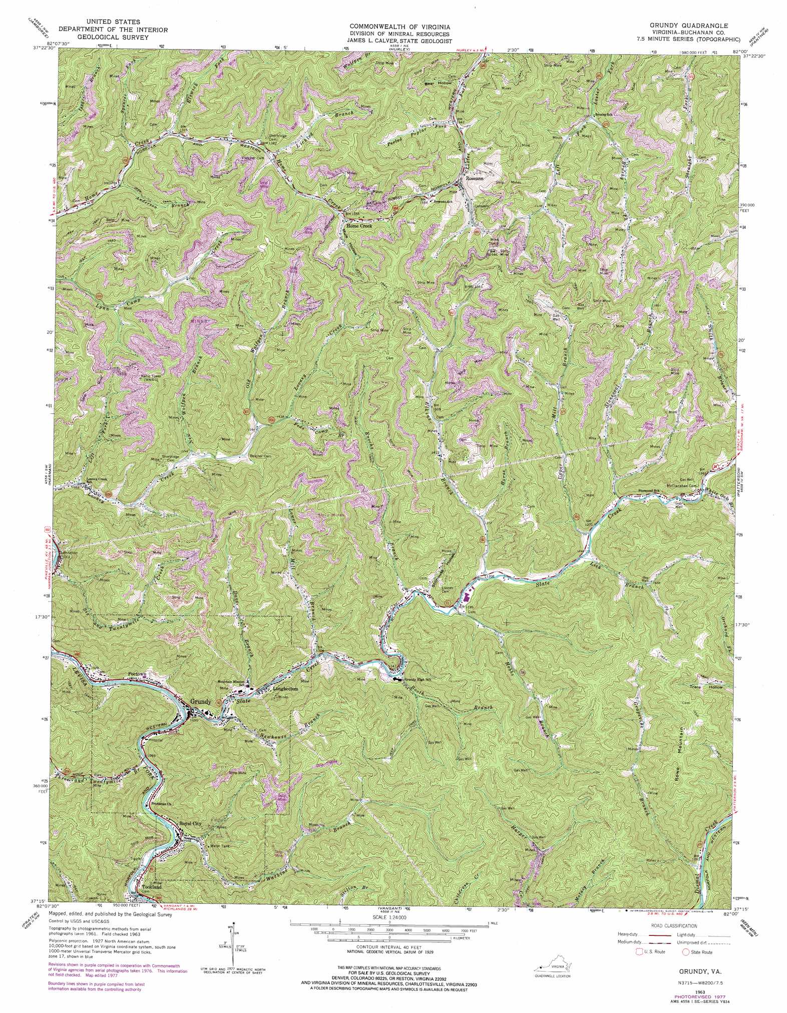
Grundy Topo Map Virginia
To zoom in, hover over the map of Grundy
USGS Topo Quad 37082c1 - 1:24,000 scale
| Topo Map Name: | Grundy |
| USGS Topo Quad ID: | 37082c1 |
| Print Size: | ca. 21 1/4" wide x 27" high |
| Southeast Coordinates: | 37.25° N latitude / 82° W longitude |
| Map Center Coordinates: | 37.3125° N latitude / 82.0625° W longitude |
| U.S. State: | VA |
| Filename: | o37082c1.jpg |
| Download Map JPG Image: | Grundy topo map 1:24,000 scale |
| Map Type: | Topographic |
| Topo Series: | 7.5´ |
| Map Scale: | 1:24,000 |
| Source of Map Images: | United States Geological Survey (USGS) |
| Alternate Map Versions: |
Grundy VA 1963, updated 1965 Download PDF Buy paper map Grundy VA 1963, updated 1978 Download PDF Buy paper map Grundy VA 2011 Download PDF Buy paper map Grundy VA 2013 Download PDF Buy paper map Grundy VA 2016 Download PDF Buy paper map |
1:24,000 Topo Quads surrounding Grundy
Belfry |
Matewan |
Majestic |
Wharncliffe |
Gilbert |
Lick Creek |
Jamboree |
Hurley |
Panther |
Iaeger |
Elkhorn City |
Harman |
Grundy |
Patterson |
Bradshaw |
Haysi |
Prater |
Vansant |
Keen Mountain |
Jewell Ridge |
Nora |
Duty |
Big A Mountain |
Honaker |
Richlands |
> Back to 37082a1 at 1:100,000 scale
> Back to 37082a1 at 1:250,000 scale
> Back to U.S. Topo Maps home
Grundy topo map: Gazetteer
Grundy: Airports
F B Fowler Heliport elevation 336m 1102′Grundy: Populated Places
Grundy elevation 323m 1059′Home Creek elevation 474m 1555′
Longbottom elevation 331m 1085′
Poetown elevation 333m 1092′
Roseann elevation 425m 1394′
Royal City elevation 325m 1066′
Tookland elevation 330m 1082′
Grundy: Streams
Anderson Branch elevation 377m 1236′Booth Branch elevation 347m 1138′
Brushy Fork elevation 412m 1351′
Dave Branch elevation 323m 1059′
Elkins Branch elevation 365m 1197′
Elswick Fork elevation 394m 1292′
Enochs Branch elevation 359m 1177′
Feds Camp Branch elevation 443m 1453′
Grape Branch elevation 381m 1250′
Hobbs Branch elevation 359m 1177′
Horse Branch elevation 386m 1266′
Left Fork Looney Creek elevation 323m 1059′
Lick Branch elevation 378m 1240′
Licklog Branch elevation 423m 1387′
Little Prater Creek elevation 328m 1076′
Lower Mill Branch elevation 335m 1099′
New Wolfpen Branch elevation 378m 1240′
Newhouse Branch elevation 325m 1066′
Old Wolfpen Branch elevation 418m 1371′
Peeled Poplar Fork elevation 406m 1332′
Slate Creek elevation 315m 1033′
Spencer Fork elevation 384m 1259′
Stonecoal Branch elevation 388m 1272′
Three and Twentymile Branch elevation 315m 1033′
Upper Mill Branch elevation 382m 1253′
Watkins Branch elevation 322m 1056′
White Oak Branch elevation 399m 1309′
Grundy: Summits
Rowe Mountain elevation 702m 2303′Grundy: Tunnels
Raitt Tunnel elevation 610m 2001′Grundy: Valleys
Bear Hollow elevation 410m 1345′Calfpen Hollow elevation 399m 1309′
Mule Hollow elevation 462m 1515′
Stillhouse Hollow elevation 366m 1200′
Grundy digital topo map on disk
Buy this Grundy topo map showing relief, roads, GPS coordinates and other geographical features, as a high-resolution digital map file on DVD:
Western Virginia & Southern West Virginia
Buy digital topo maps: Western Virginia & Southern West Virginia