Hindman Topo Map Kentucky
To zoom in, hover over the map of Hindman
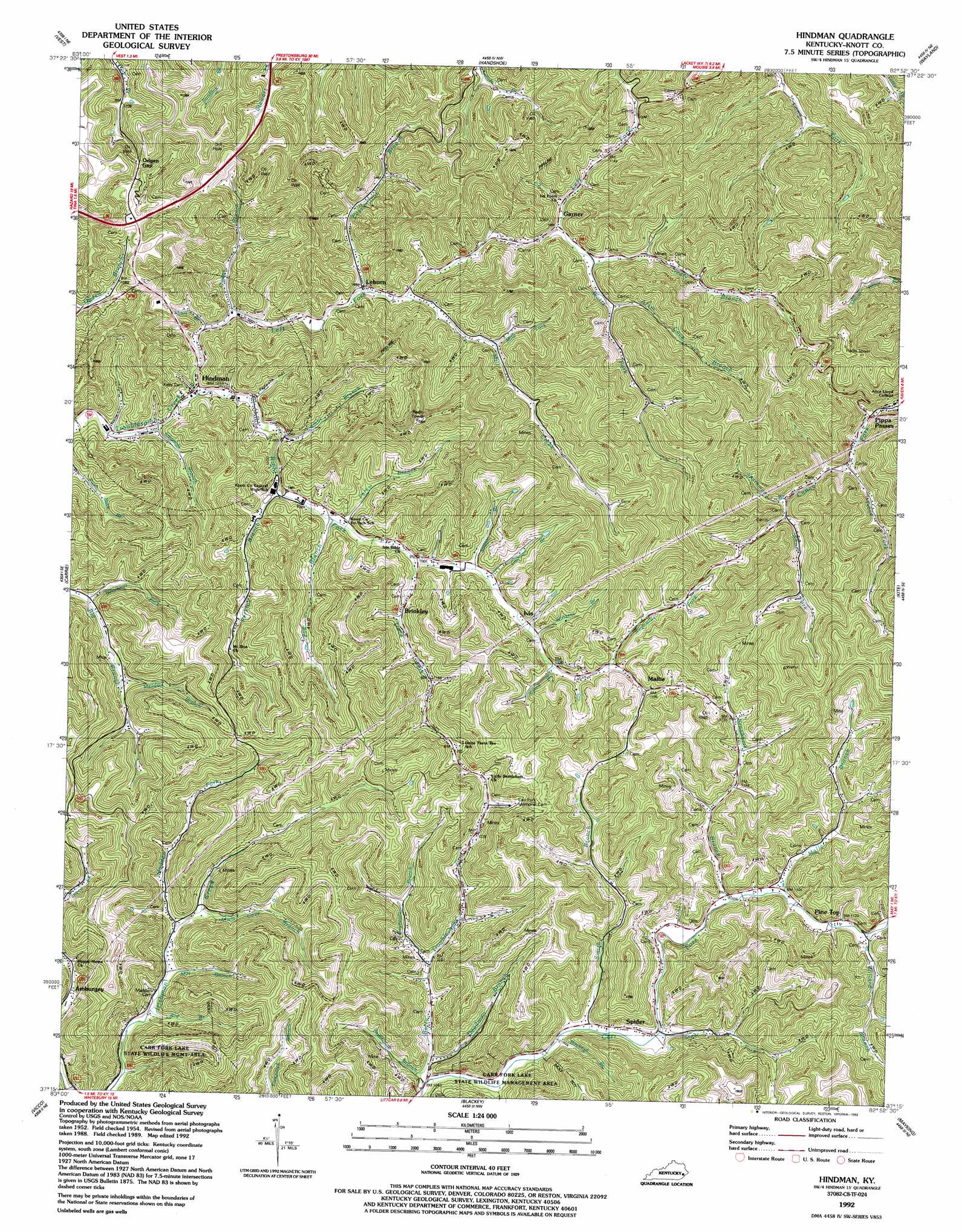
USGS Topo Quad 37082c8 - 1:24,000 scale
| Topo Map Name: | Hindman |
| USGS Topo Quad ID: | 37082c8 |
| Print Size: | ca. 21 1/4" wide x 27" high |
| Southeast Coordinates: | 37.25° N latitude / 82.875° W longitude |
| Map Center Coordinates: | 37.3125° N latitude / 82.9375° W longitude |
| U.S. State: | KY |
| Filename: | o37082c8.jpg |
| Download Map JPG Image: | Hindman topo map 1:24,000 scale |
| Map Type: | Topographic |
| Topo Series: | 7.5´ |
| Map Scale: | 1:24,000 |
| Source of Map Images: | United States Geological Survey (USGS) |
| Alternate Map Versions: |
Hindman KY 1954, updated 1955 Download PDF Buy paper map Hindman KY 1954, updated 1962 Download PDF Buy paper map Hindman KY 1992, updated 1992 Download PDF Buy paper map Hindman KY 2010 Download PDF Buy paper map Hindman KY 2013 Download PDF Buy paper map Hindman KY 2016 Download PDF Buy paper map |
1:24,000 Topo Quads surrounding Hindman
Guage |
Tiptop |
David |
Martin |
Harold |
Noble |
Vest |
Handshoe |
Wayland |
Mcdowell |
Hazard North |
Carrie |
Hindman |
Kite |
Wheelwright |
Hazard South |
Vicco |
Blackey |
Mayking |
Jenkins West |
Leatherwood |
Tilford |
Roxana |
Whitesburg |
Flat Gap |
> Back to 37082a1 at 1:100,000 scale
> Back to 37082a1 at 1:250,000 scale
> Back to U.S. Topo Maps home
Hindman topo map: Gazetteer
Hindman: Populated Places
Amburgey elevation 339m 1112′Brinkley elevation 359m 1177′
Garner elevation 392m 1286′
Hindman elevation 340m 1115′
Leburn elevation 330m 1082′
Odgen Gap elevation 432m 1417′
Pine Top elevation 344m 1128′
Spider elevation 327m 1072′
Hindman: Post Offices
Amburgey Post Office (historical) elevation 341m 1118′Brinkley Post Office (historical) elevation 329m 1079′
Dillon Post Office (historical) elevation 325m 1066′
Garner Post Office (historical) elevation 353m 1158′
High Rock Post Office (historical) elevation 316m 1036′
Ivis Post Office (historical) elevation 329m 1079′
Lebum Post Office (historical) elevation 321m 1053′
Mallet Post Office elevation 363m 1190′
May Post Office (historical) elevation 354m 1161′
McPherson Post Office (historical) elevation 326m 1069′
Pine Top Post Office (historical) elevation 334m 1095′
Saint Cloud Post Office (historical) elevation 351m 1151′
Spider Post Office (historical) elevation 322m 1056′
Hindman: Streams
Alum Cave Branch elevation 333m 1092′Alum Cave Branch elevation 346m 1135′
Amburgey Branch elevation 311m 1020′
Beechnut Fork elevation 322m 1056′
Betty Troublesome Creek elevation 329m 1079′
Big Branch elevation 322m 1056′
Branhams Branch elevation 333m 1092′
Buckeye Branch elevation 323m 1059′
Calhoun Branch elevation 338m 1108′
Cave Branch elevation 321m 1053′
Combs Branch elevation 319m 1046′
Deadman Branch elevation 323m 1059′
Edwards Branch elevation 311m 1020′
Left Fork Troublesome Creek elevation 311m 1020′
Madden Fork elevation 327m 1072′
Mallet Branch elevation 338m 1108′
Meadow Branch elevation 338m 1108′
Mile Fork elevation 376m 1233′
Mill Branch elevation 325m 1066′
Mill Creek elevation 333m 1092′
Nealy Branch elevation 347m 1138′
Owens Branch elevation 312m 1023′
Parks Branch elevation 326m 1069′
Perkins Branch elevation 319m 1046′
Pigman Branch elevation 341m 1118′
Possumtrot Branch elevation 325m 1066′
Reynolds Branch elevation 336m 1102′
Reynolds Fork elevation 348m 1141′
Right Fork Troublesome Creek elevation 311m 1020′
Sams Branch elevation 340m 1115′
Sawpit Branch elevation 347m 1138′
Short Branch elevation 311m 1020′
Short Fork elevation 338m 1108′
Smith Branch elevation 321m 1053′
Sparkman Branch elevation 331m 1085′
Steer Fork elevation 322m 1056′
Stillhouse Branch elevation 323m 1059′
Trace Fork elevation 324m 1062′
Trace Fork elevation 317m 1040′
Trace Fork elevation 313m 1026′
Watkins Branch elevation 346m 1135′
Watts Fork elevation 358m 1174′
Willard Branch elevation 338m 1108′
Hindman: Valleys
Tadpole Hollow elevation 324m 1062′Walnut Hollow elevation 362m 1187′
Hindman digital topo map on disk
Buy this Hindman topo map showing relief, roads, GPS coordinates and other geographical features, as a high-resolution digital map file on DVD:
Western Virginia & Southern West Virginia
Buy digital topo maps: Western Virginia & Southern West Virginia