Pikeville Topo Map Kentucky
To zoom in, hover over the map of Pikeville
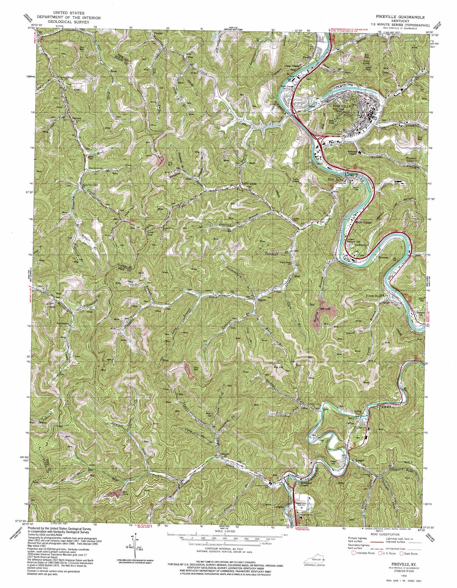
USGS Topo Quad 37082d5 - 1:24,000 scale
| Topo Map Name: | Pikeville |
| USGS Topo Quad ID: | 37082d5 |
| Print Size: | ca. 21 1/4" wide x 27" high |
| Southeast Coordinates: | 37.375° N latitude / 82.5° W longitude |
| Map Center Coordinates: | 37.4375° N latitude / 82.5625° W longitude |
| U.S. State: | KY |
| Filename: | o37082d5.jpg |
| Download Map JPG Image: | Pikeville topo map 1:24,000 scale |
| Map Type: | Topographic |
| Topo Series: | 7.5´ |
| Map Scale: | 1:24,000 |
| Source of Map Images: | United States Geological Survey (USGS) |
| Alternate Map Versions: |
Pikeville KY 1954, updated 1956 Download PDF Buy paper map Pikeville KY 1954, updated 1967 Download PDF Buy paper map Pikeville KY 1978, updated 1979 Download PDF Buy paper map Pikeville KY 1992, updated 1992 Download PDF Buy paper map Pikeville KY 2010 Download PDF Buy paper map Pikeville KY 2013 Download PDF Buy paper map Pikeville KY 2016 Download PDF Buy paper map |
1:24,000 Topo Quads surrounding Pikeville
Prestonsburg |
Lancer |
Thomas |
Varney |
Williamson |
Martin |
Harold |
Broad Bottom |
Meta |
Belfry |
Wayland |
Mcdowell |
Pikeville |
Millard |
Lick Creek |
Kite |
Wheelwright |
Dorton |
Hellier |
Elkhorn City |
Mayking |
Jenkins West |
Jenkins East |
Clintwood |
Haysi |
> Back to 37082a1 at 1:100,000 scale
> Back to 37082a1 at 1:250,000 scale
> Back to U.S. Topo Maps home
Pikeville topo map: Gazetteer
Pikeville: Bridges
Lower Bridge elevation 208m 682′Middle Bridge elevation 208m 682′
Upper Bridge elevation 209m 685′
Pikeville: Flats
Narrows Bottom elevation 213m 698′Peach Orchard Bottom elevation 208m 682′
Pikeville: Gaps
Toler Gap elevation 354m 1161′Pikeville: Populated Places
Bear Fork elevation 288m 944′Collins elevation 219m 718′
Douglas elevation 237m 777′
Fords Branch elevation 211m 692′
Harrolds Branch elevation 229m 751′
Keel Addition elevation 200m 656′
Kewanee elevation 210m 688′
Little Dixie elevation 232m 761′
Lower Chloe elevation 208m 682′
Mayo Village elevation 214m 702′
Osborn elevation 233m 764′
Pauley elevation 200m 656′
Pigeon elevation 231m 757′
Pikeville elevation 207m 679′
Pleasant Valley elevation 242m 793′
Robinson Creek elevation 231m 757′
Titan Siding elevation 208m 682′
Upper Little Creek elevation 267m 875′
Yeager elevation 230m 754′
Yorktown elevation 210m 688′
Pikeville: Post Offices
Bolyn Post Office (historical) elevation 243m 797′Burns Post Office (historical) elevation 225m 738′
Elksam Post Office (historical) elevation 219m 718′
Hildason Post Office (historical) elevation 241m 790′
Kewnee Post Office (historical) elevation 215m 705′
Pauley Post Office (historical) elevation 201m 659′
Richam Post Office (historical) elevation 217m 711′
Yeager Post Office (historical) elevation 230m 754′
Pikeville: Ridges
Cider Poor Farm Ridge elevation 355m 1164′Pikeville: Streams
Aker Branch elevation 294m 964′Bear Fork elevation 244m 800′
Big Rock Branch of Bear Fork elevation 287m 941′
Buckhorn Branch elevation 271m 889′
Bush Branch elevation 245m 803′
Cager Branch elevation 231m 757′
Cane Branch elevation 253m 830′
Cane Fork elevation 244m 800′
Cedar Creek elevation 205m 672′
Compton Branch elevation 231m 757′
Compton Branch elevation 212m 695′
Deadening Fork elevation 248m 813′
Dog Fork elevation 243m 797′
Ferguson Creek elevation 208m 682′
Fords Branch elevation 205m 672′
Groundhog Fork elevation 261m 856′
Harolds Branch elevation 206m 675′
Hoopwood Branch elevation 251m 823′
Horseshoe Branch elevation 237m 777′
Island Creek elevation 198m 649′
Ivy Creek elevation 207m 679′
Keathley Branch elevation 269m 882′
Lank Branch elevation 200m 656′
Left Fork Toler Creek elevation 220m 721′
Lick Fork elevation 225m 738′
Licklo Fork elevation 304m 997′
Little Creek elevation 231m 757′
Long Branch elevation 255m 836′
Long Branch elevation 223m 731′
Long Branch elevation 255m 836′
Lower Chloe Creek elevation 207m 679′
Marion Branch elevation 206m 675′
McKenney Branch elevation 290m 951′
Peachorchard Branch elevation 230m 754′
Peters Branch elevation 233m 764′
Pigeonroost Branch elevation 306m 1003′
Raccoon Branch elevation 219m 718′
Rachel Fork elevation 236m 774′
Ratliff Creek elevation 194m 636′
Ray Branch elevation 280m 918′
Right Fork Island Creek elevation 206m 675′
Right Fork of Horseshoe Branch elevation 242m 793′
Road Branch elevation 239m 784′
Roberts Branch elevation 290m 951′
Robinson Creek elevation 235m 770′
Sam Hall Branch elevation 315m 1033′
Sookeys Creek elevation 218m 715′
Spears Branch elevation 254m 833′
Stagger Fork elevation 224m 734′
Stillhouse Branch elevation 255m 836′
Straight Fork elevation 267m 875′
Straight Fork elevation 240m 787′
Sugar Camp Creek elevation 240m 787′
Sword Fork elevation 240m 787′
Taylor Branch elevation 222m 728′
Town Fork elevation 267m 875′
Wager Fork elevation 243m 797′
Pikeville: Summits
Big Hill elevation 468m 1535′Duty Knob elevation 463m 1519′
Peach Orchard Mountain elevation 447m 1466′
Pikeville: Valleys
Boyd Hollow elevation 243m 797′Cline Hollow elevation 212m 695′
Crab Apple Hollow elevation 245m 803′
Crow Hollow elevation 245m 803′
Keyser Hollow elevation 209m 685′
Mays Hollow elevation 232m 761′
Payne Hollow elevation 303m 994′
Powderhouse Hollow elevation 231m 757′
Rich Hollow elevation 208m 682′
Pikeville digital topo map on disk
Buy this Pikeville topo map showing relief, roads, GPS coordinates and other geographical features, as a high-resolution digital map file on DVD:
Western Virginia & Southern West Virginia
Buy digital topo maps: Western Virginia & Southern West Virginia