Mcdowell Topo Map Kentucky
To zoom in, hover over the map of Mcdowell
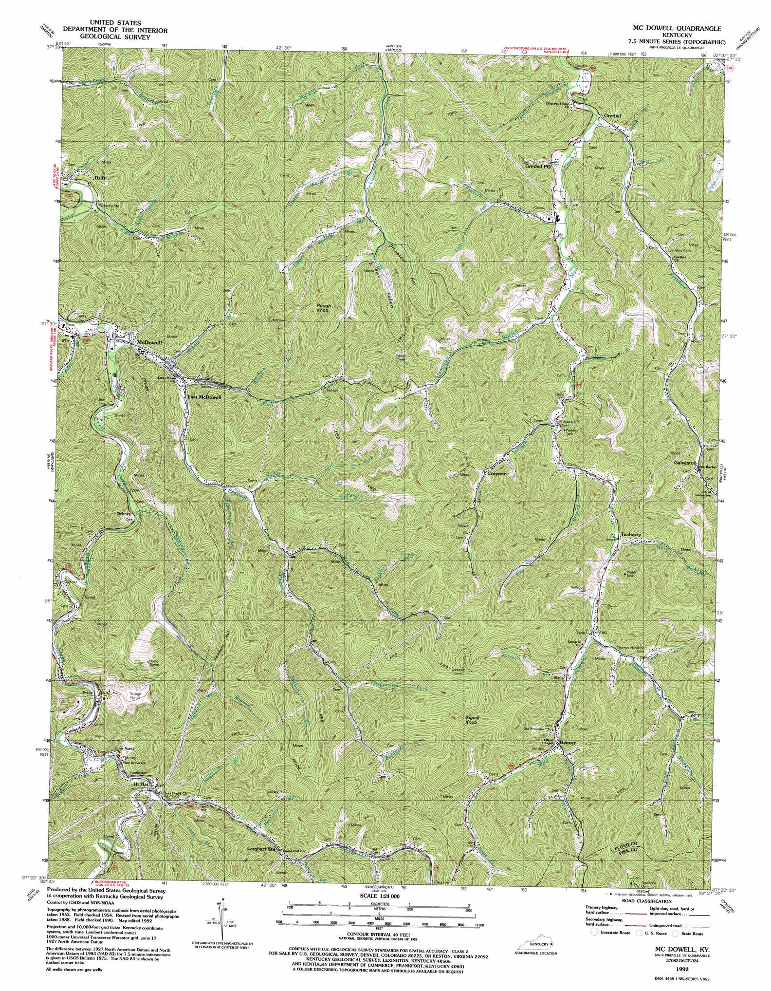
USGS Topo Quad 37082d6 - 1:24,000 scale
| Topo Map Name: | Mcdowell |
| USGS Topo Quad ID: | 37082d6 |
| Print Size: | ca. 21 1/4" wide x 27" high |
| Southeast Coordinates: | 37.375° N latitude / 82.625° W longitude |
| Map Center Coordinates: | 37.4375° N latitude / 82.6875° W longitude |
| U.S. State: | KY |
| Filename: | o37082d6.jpg |
| Download Map JPG Image: | Mcdowell topo map 1:24,000 scale |
| Map Type: | Topographic |
| Topo Series: | 7.5´ |
| Map Scale: | 1:24,000 |
| Source of Map Images: | United States Geological Survey (USGS) |
| Alternate Map Versions: |
Mc Dowell KY 1954, updated 1956 Download PDF Buy paper map Mc Dowell KY 1954, updated 1971 Download PDF Buy paper map Mc Dowell KY 1954, updated 1979 Download PDF Buy paper map Mc Dowell KY 1992, updated 1992 Download PDF Buy paper map McDowell KY 2010 Download PDF Buy paper map McDowell KY 2013 Download PDF Buy paper map McDowell KY 2016 Download PDF Buy paper map |
1:24,000 Topo Quads surrounding Mcdowell
Ivyton |
Prestonsburg |
Lancer |
Thomas |
Varney |
David |
Martin |
Harold |
Broad Bottom |
Meta |
Handshoe |
Wayland |
Mcdowell |
Pikeville |
Millard |
Hindman |
Kite |
Wheelwright |
Dorton |
Hellier |
Blackey |
Mayking |
Jenkins West |
Jenkins East |
Clintwood |
> Back to 37082a1 at 1:100,000 scale
> Back to 37082a1 at 1:250,000 scale
> Back to U.S. Topo Maps home
Mcdowell topo map: Gazetteer
Mcdowell: Populated Places
Beaver elevation 296m 971′Craynor elevation 267m 875′
Drift elevation 218m 715′
East McDowell elevation 236m 774′
Galveston elevation 277m 908′
Grethel elevation 219m 718′
Hi Hat elevation 315m 1033′
McDowell elevation 215m 705′
Orkney elevation 227m 744′
Price elevation 239m 784′
Teaberry elevation 260m 853′
Mcdowell: Post Offices
Galveston Post Office (historical) elevation 277m 908′Grethel Post Office elevation 231m 757′
Mcdowell: Streams
Akers Branch elevation 226m 741′Andy Branch elevation 285m 935′
Biglick Branch elevation 294m 964′
Branham Creek elevation 206m 675′
Bryant Branch elevation 243m 797′
Buckhorn Fork elevation 361m 1184′
Clear Creek elevation 247m 810′
Deal Branch elevation 214m 702′
Doty Branch elevation 213m 698′
Dry Branch elevation 242m 793′
Frasure Branch elevation 209m 685′
Frasure Creek elevation 217m 711′
Frozen Creek elevation 213m 698′
Gap Fork elevation 308m 1010′
Gearheart Branch elevation 244m 800′
Hall Fork elevation 219m 718′
Hamilton Branch elevation 218m 715′
Hays Branch elevation 255m 836′
Hoods Fork elevation 248m 813′
Hopkins Branch elevation 350m 1148′
Left Fork Frasure Branch elevation 236m 774′
Left Fork Hoods Fork elevation 280m 918′
Left Fork Tinker Fork elevation 304m 997′
Little Branch elevation 288m 944′
Lower Wolfpen Branch elevation 247m 810′
Margarett Fork elevation 326m 1069′
Middle Branch Frasure Creek elevation 218m 715′
Mink Branch elevation 236m 774′
Mitchell Branch elevation 276m 905′
Moore Fork elevation 353m 1158′
Morgan Fork elevation 231m 757′
Neck Branch elevation 268m 879′
Ned Fork elevation 265m 869′
Newman Branch elevation 266m 872′
Osborne Branch elevation 292m 958′
Polly Spencer Branch elevation 219m 718′
Poplarlick Fork elevation 317m 1040′
Red Morg Branch elevation 255m 836′
Reynolds Branch elevation 274m 898′
Reynolds Branch elevation 314m 1030′
Right Fork Tinker Fork elevation 304m 997′
Rough Branch elevation 242m 793′
Simpson Branch elevation 208m 682′
Spewing Camp Branch elevation 219m 718′
Step Branch elevation 221m 725′
Sturgill Branch elevation 219m 718′
Sword Branch elevation 209m 685′
Tackett Branch elevation 207m 679′
Tackett Fork elevation 315m 1033′
Tinker Fork elevation 266m 872′
Upper Wolfpen Branch elevation 271m 889′
Mcdowell: Summits
Buzzard Rock elevation 460m 1509′Rough Knob elevation 544m 1784′
Signal Knob elevation 629m 2063′
Mcdowell: Valleys
Buckhorn Hollow elevation 340m 1115′Indian Grave Hollow elevation 243m 797′
Newsom Hollow elevation 339m 1112′
Rich Hollow elevation 276m 905′
Stonecoal Hollow elevation 267m 875′
Mcdowell digital topo map on disk
Buy this Mcdowell topo map showing relief, roads, GPS coordinates and other geographical features, as a high-resolution digital map file on DVD:
Western Virginia & Southern West Virginia
Buy digital topo maps: Western Virginia & Southern West Virginia