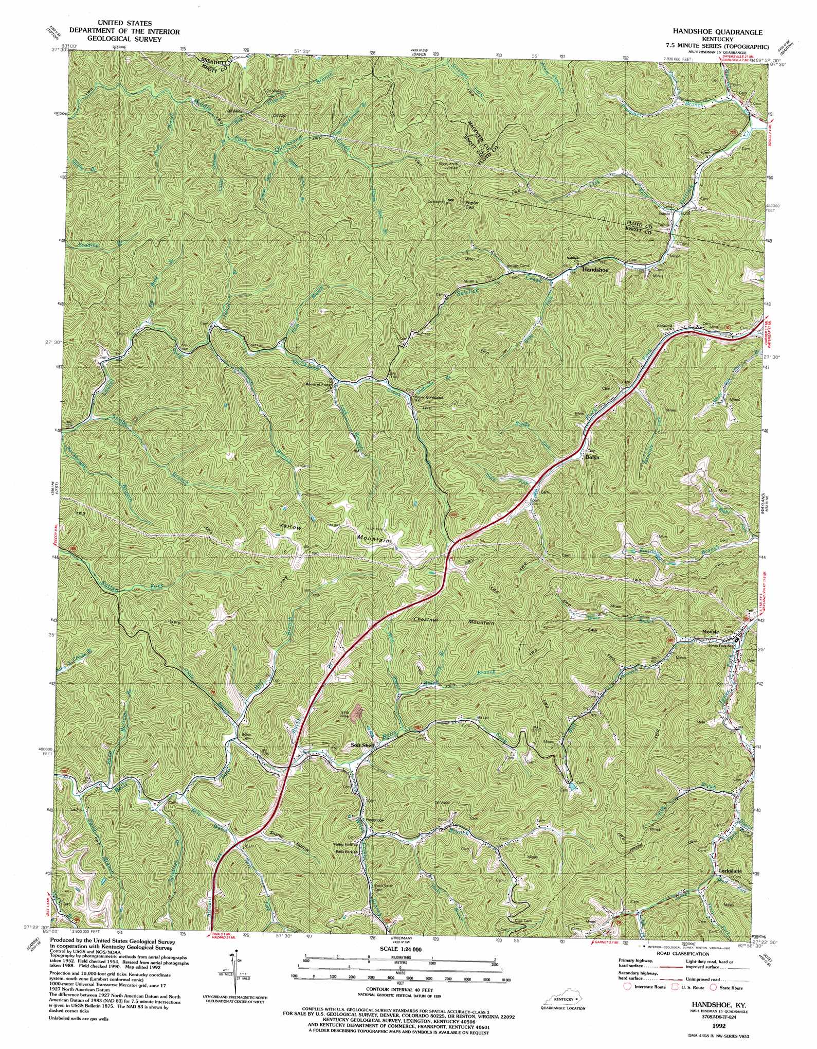
Handshoe Topo Map Kentucky
To zoom in, hover over the map of Handshoe
USGS Topo Quad 37082d8 - 1:24,000 scale
| Topo Map Name: | Handshoe |
| USGS Topo Quad ID: | 37082d8 |
| Print Size: | ca. 21 1/4" wide x 27" high |
| Southeast Coordinates: | 37.375° N latitude / 82.875° W longitude |
| Map Center Coordinates: | 37.4375° N latitude / 82.9375° W longitude |
| U.S. State: | KY |
| Filename: | o37082d8.jpg |
| Download Map JPG Image: | Handshoe topo map 1:24,000 scale |
| Map Type: | Topographic |
| Topo Series: | 7.5´ |
| Map Scale: | 1:24,000 |
| Source of Map Images: | United States Geological Survey (USGS) |
| Alternate Map Versions: |
Handshoe KY 1954, updated 1956 Download PDF Buy paper map Handshoe KY 1954, updated 1971 Download PDF Buy paper map Handshoe KY 1954, updated 1977 Download PDF Buy paper map Handshoe KY 1992, updated 1992 Download PDF Buy paper map Handshoe KY 2010 Download PDF Buy paper map Handshoe KY 2013 Download PDF Buy paper map Handshoe KY 2016 Download PDF Buy paper map |
1:24,000 Topo Quads surrounding Handshoe
Seitz |
Salyersville South |
Ivyton |
Prestonsburg |
Lancer |
Guage |
Tiptop |
David |
Martin |
Harold |
Noble |
Vest |
Handshoe |
Wayland |
Mcdowell |
Hazard North |
Carrie |
Hindman |
Kite |
Wheelwright |
Hazard South |
Vicco |
Blackey |
Mayking |
Jenkins West |
> Back to 37082a1 at 1:100,000 scale
> Back to 37082a1 at 1:250,000 scale
> Back to U.S. Topo Maps home
Handshoe topo map: Gazetteer
Handshoe: Gaps
Poplar Gap elevation 423m 1387′Handshoe: Parks
Ball Creek Community Park elevation 344m 1128′Handshoe: Populated Places
Bolyn elevation 312m 1023′Handshoe elevation 303m 994′
Larkslane elevation 270m 885′
Mousie elevation 243m 797′
Rock Fork elevation 285m 935′
Soft Shell elevation 343m 1125′
Handshoe: Post Offices
Elmrock Post Office (historical) elevation 317m 1040′Handshoe Post Office (historical) elevation 270m 885′
Soft Shell Post Office (historical) elevation 349m 1145′
Yellow Mountain Post Office (historical) elevation 342m 1122′
Handshoe: Ridges
Scaffd and Lacy Ridge elevation 472m 1548′Handshoe: Streams
Ball Branch elevation 243m 797′Big Bend Branch elevation 323m 1059′
Big Firecoal Branch elevation 339m 1112′
Bolen Branch elevation 369m 1210′
Bruce Branch elevation 247m 810′
Brushy Fork elevation 290m 951′
Bucks Branch elevation 340m 1115′
Combs Branch elevation 320m 1049′
Combs Branch elevation 343m 1125′
Dismal Branch elevation 256m 839′
Fitch Branch elevation 350m 1148′
Flat Rockhouse Branch elevation 376m 1233′
Hicks Branch elevation 353m 1158′
House Seat Branch elevation 365m 1197′
Joshua Branch elevation 333m 1092′
Knob Bottom Branch elevation 328m 1076′
Lick Branch elevation 352m 1154′
Lick Fork elevation 225m 738′
Little Branch elevation 328m 1076′
Little Firecoal Branch elevation 333m 1092′
Long Branch elevation 365m 1197′
Long Fork elevation 293m 961′
Lower Twin Branch elevation 339m 1112′
Mill Branch elevation 329m 1079′
Mine Branch elevation 350m 1148′
Newman Branch elevation 328m 1076′
Oldhouse Branch elevation 371m 1217′
Patton Fork elevation 252m 826′
Plum Branch elevation 324m 1062′
Plummer Branch elevation 219m 718′
Pond Branch elevation 328m 1076′
Raccoon Branch elevation 219m 718′
Right Fork Fourmile Branch elevation 237m 777′
Rockhouse Branch elevation 317m 1040′
Sandlick Branch elevation 328m 1076′
Short Fork elevation 273m 895′
Snag Fork elevation 252m 826′
Spruce Pine Branch elevation 368m 1207′
Stewart Fork elevation 342m 1122′
Sycamore Fork elevation 275m 902′
Terry Branch elevation 342m 1122′
Terry Branch elevation 328m 1076′
Terry Fork elevation 270m 885′
Trace Fork elevation 304m 997′
Turtle Branch elevation 266m 872′
Upper Twin Branch elevation 340m 1115′
White Oak Flat Branch elevation 245m 803′
Wiley Branch elevation 340m 1115′
Handshoe: Summits
Chestnut Mountain elevation 537m 1761′Yellow Mountain elevation 501m 1643′
Handshoe: Valleys
Shanty Hollow elevation 340m 1115′Handshoe digital topo map on disk
Buy this Handshoe topo map showing relief, roads, GPS coordinates and other geographical features, as a high-resolution digital map file on DVD:
Western Virginia & Southern West Virginia
Buy digital topo maps: Western Virginia & Southern West Virginia