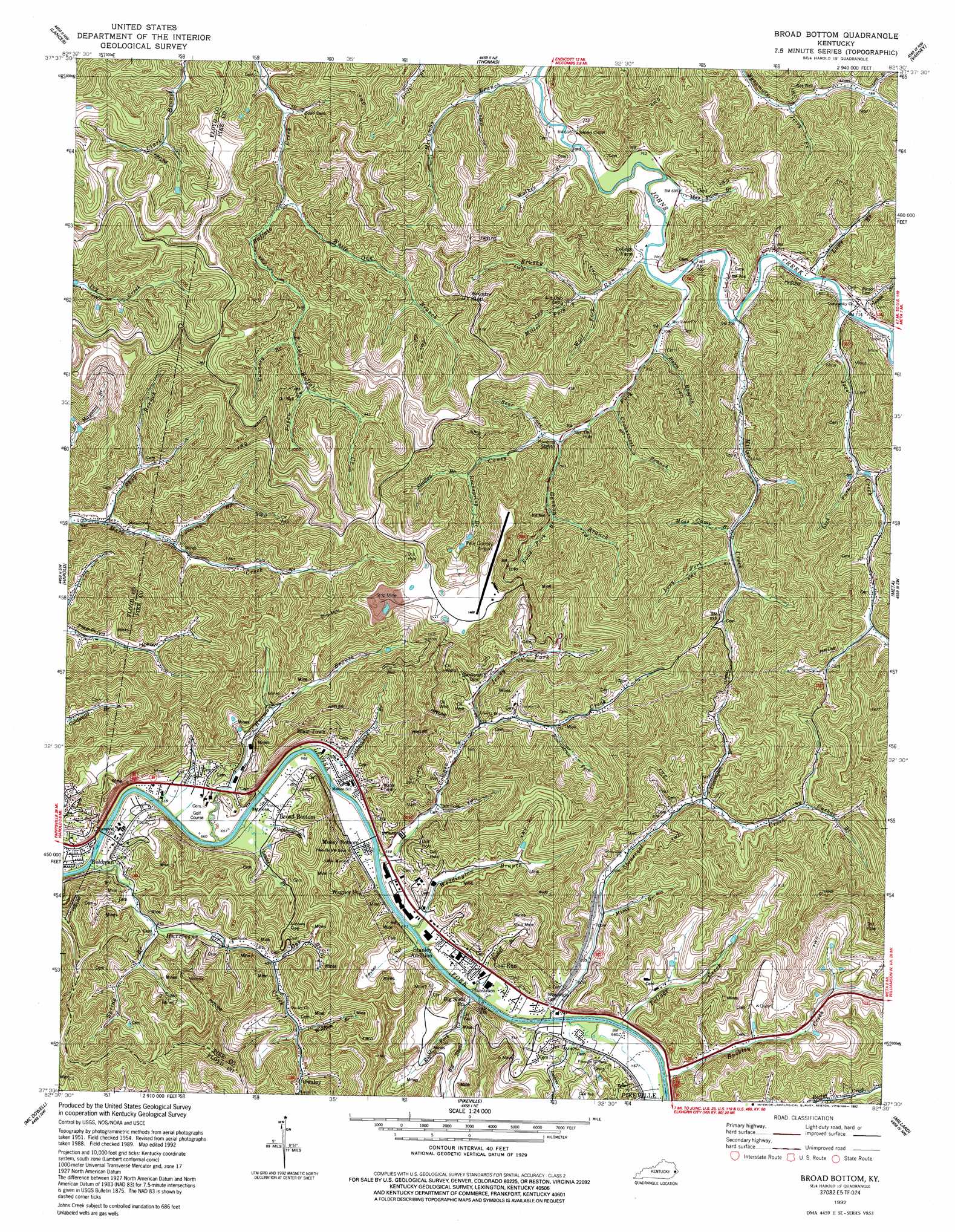
Broad Bottom Topo Map Kentucky
To zoom in, hover over the map of Broad Bottom
USGS Topo Quad 37082e5 - 1:24,000 scale
| Topo Map Name: | Broad Bottom |
| USGS Topo Quad ID: | 37082e5 |
| Print Size: | ca. 21 1/4" wide x 27" high |
| Southeast Coordinates: | 37.5° N latitude / 82.5° W longitude |
| Map Center Coordinates: | 37.5625° N latitude / 82.5625° W longitude |
| U.S. State: | KY |
| Filename: | o37082e5.jpg |
| Download Map JPG Image: | Broad Bottom topo map 1:24,000 scale |
| Map Type: | Topographic |
| Topo Series: | 7.5´ |
| Map Scale: | 1:24,000 |
| Source of Map Images: | United States Geological Survey (USGS) |
| Alternate Map Versions: |
Broad Bottom KY 1954, updated 1955 Download PDF Buy paper map Broad Bottom KY 1979, updated 1979 Download PDF Buy paper map Broad Bottom KY 1992, updated 1992 Download PDF Buy paper map Broad Bottom KY 2010 Download PDF Buy paper map Broad Bottom KY 2013 Download PDF Buy paper map Broad Bottom KY 2016 Download PDF Buy paper map |
1:24,000 Topo Quads surrounding Broad Bottom
Paintsville |
Offutt |
Inez |
Kermit |
Naugatuck |
Prestonsburg |
Lancer |
Thomas |
Varney |
Williamson |
Martin |
Harold |
Broad Bottom |
Meta |
Belfry |
Wayland |
Mcdowell |
Pikeville |
Millard |
Lick Creek |
Kite |
Wheelwright |
Dorton |
Hellier |
Elkhorn City |
> Back to 37082e1 at 1:100,000 scale
> Back to 37082a1 at 1:250,000 scale
> Back to U.S. Topo Maps home
Broad Bottom topo map: Gazetteer
Broad Bottom: Airports
Pike County Airport-Hatcher Field elevation 441m 1446′Pikeville Airfield elevation 204m 669′
Broad Bottom: Bridges
Boldman Bridge elevation 192m 629′Cold Run Bridge elevation 194m 636′
Mossy Bottom Bridge elevation 201m 659′
Broad Bottom: Gaps
Brushy Gap elevation 357m 1171′Lowes Gap elevation 298m 977′
Broad Bottom: Populated Places
Big Shoal elevation 205m 672′Blair Town elevation 204m 669′
Boldman elevation 200m 656′
Broad Bottom elevation 202m 662′
Coal Run Village elevation 201m 659′
Joes Creek elevation 219m 718′
Little Floyd County elevation 236m 774′
Miller Creek elevation 217m 711′
Mossy Bottom elevation 200m 656′
Owsley elevation 230m 754′
Stanley elevation 212m 695′
Stanley Addition elevation 200m 656′
Wagoner elevation 231m 757′
Broad Bottom: Post Offices
Big Shoal Post Office (historical) elevation 202m 662′Coal Run Post Office elevation 207m 679′
Diaz Post Office (historical) elevation 280m 918′
Jake Post Office (historical) elevation 244m 800′
Joe Post Office (historical) elevation 213m 698′
John Post Office (historical) elevation 215m 705′
Johns Post Office (historical) elevation 214m 702′
Keyser Post Office (historical) elevation 203m 666′
May Flower Post Office (historical) elevation 215m 705′
Owsley Post Office (historical) elevation 230m 754′
Pikeville Post Office elevation 206m 675′
Broad Bottom: Reservoirs
Lake Joann elevation 206m 675′Broad Bottom: Streams
Barn Branch elevation 213m 698′Bear Fork elevation 239m 784′
Big Shoal Creek elevation 195m 639′
Broomstraw Fork elevation 230m 754′
Brushy Run elevation 212m 695′
Buckley Creek elevation 195m 639′
Cabin Branch elevation 195m 639′
Caney Fork elevation 212m 695′
Clevingers Branch elevation 224m 734′
Coal Run elevation 199m 652′
Cowpen Creek elevation 194m 636′
Cranesnest Branch elevation 226m 741′
Cushaw Branch elevation 267m 875′
Fox Bottom elevation 197m 646′
Gannon Branch elevation 231m 757′
Gap Branch elevation 225m 738′
Harmond Branch elevation 194m 636′
Horse Pen Branch elevation 207m 679′
Hurricane Creek elevation 192m 629′
Jenny Fork elevation 215m 705′
Jerry Fork elevation 230m 754′
Jimmy Branch elevation 216m 708′
Joes Creek elevation 214m 702′
Kelthly Fork elevation 229m 751′
Kinnikinnick Branch elevation 194m 636′
Lackens Branch elevation 195m 639′
Left Fork of Toms Creek elevation 306m 1003′
Lick Fork elevation 230m 754′
Long Branch elevation 240m 787′
Long Fork elevation 253m 830′
Lowe Branch elevation 212m 695′
Lowes Branch elevation 194m 636′
May Farm Branch elevation 209m 685′
McCombs Branch elevation 207m 679′
Miller Creek elevation 212m 695′
Miller Fork elevation 224m 734′
Mims Branch elevation 207m 679′
Moss Camp Branch elevation 242m 793′
Nunnary Branch elevation 261m 856′
Oldhouse Branch elevation 199m 652′
Papaw Branch elevation 272m 892′
Pinson Branch elevation 213m 698′
Ratliff Branch elevation 195m 639′
Right Fork Big Shoal Creek elevation 204m 669′
Road Fork Branch elevation 254m 833′
Rockspring Branch elevation 259m 849′
Shop Branch elevation 205m 672′
Spring Branch elevation 202m 662′
Stonecoal Creek elevation 195m 639′
Stratton Branch elevation 259m 849′
Tollage Creek elevation 195m 639′
Walker Branch elevation 207m 679′
Weddington Branch elevation 194m 636′
White Oak Branch elevation 231m 757′
Wolf Fork elevation 221m 725′
Wolfpen Branch elevation 217m 711′
Broad Bottom: Summits
Coal Run Hill elevation 223m 731′Broad Bottom: Valleys
Deskins Hollow elevation 206m 675′Edmonds Hollow elevation 244m 800′
Keyser Hollow elevation 196m 643′
Woodlands Acres elevation 257m 843′
Broad Bottom digital topo map on disk
Buy this Broad Bottom topo map showing relief, roads, GPS coordinates and other geographical features, as a high-resolution digital map file on DVD:
Western Virginia & Southern West Virginia
Buy digital topo maps: Western Virginia & Southern West Virginia