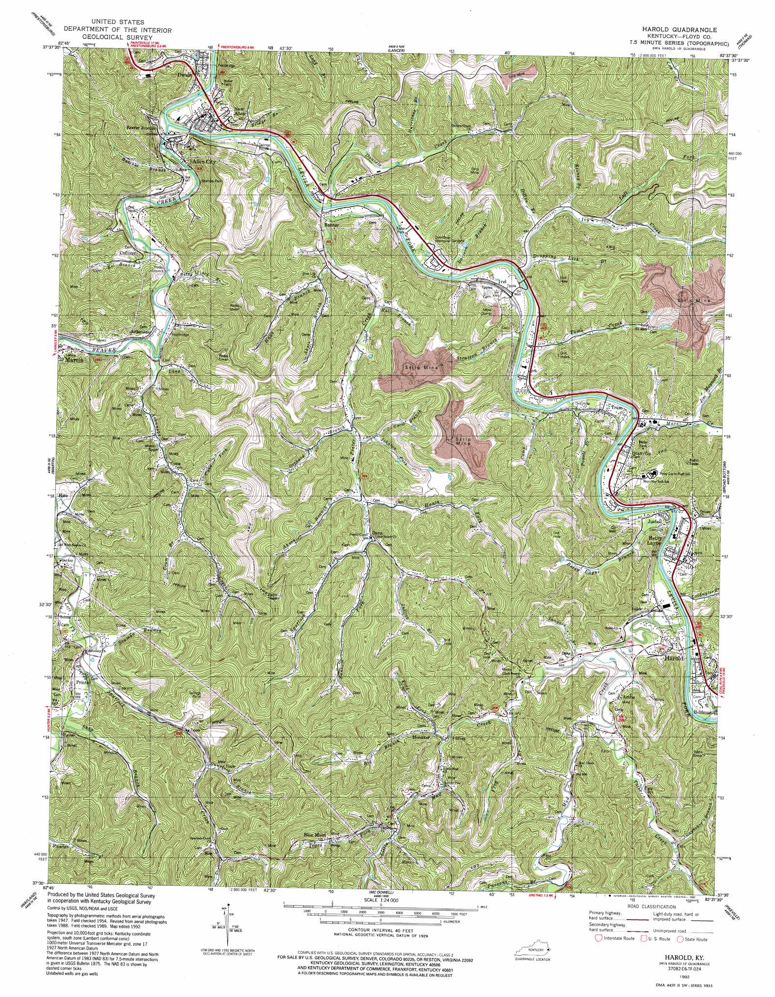
Harold Topo Map Kentucky
To zoom in, hover over the map of Harold
USGS Topo Quad 37082e6 - 1:24,000 scale
| Topo Map Name: | Harold |
| USGS Topo Quad ID: | 37082e6 |
| Print Size: | ca. 21 1/4" wide x 27" high |
| Southeast Coordinates: | 37.5° N latitude / 82.625° W longitude |
| Map Center Coordinates: | 37.5625° N latitude / 82.6875° W longitude |
| U.S. State: | KY |
| Filename: | o37082e6.jpg |
| Download Map JPG Image: | Harold topo map 1:24,000 scale |
| Map Type: | Topographic |
| Topo Series: | 7.5´ |
| Map Scale: | 1:24,000 |
| Source of Map Images: | United States Geological Survey (USGS) |
| Alternate Map Versions: |
Harold KY 1954, updated 1955 Download PDF Buy paper map Harold KY 1954, updated 1967 Download PDF Buy paper map Harold KY 1979, updated 1979 Download PDF Buy paper map Harold KY 1992, updated 1992 Download PDF Buy paper map Harold KY 2010 Download PDF Buy paper map Harold KY 2013 Download PDF Buy paper map Harold KY 2016 Download PDF Buy paper map |
1:24,000 Topo Quads surrounding Harold
Oil Springs |
Paintsville |
Offutt |
Inez |
Kermit |
Ivyton |
Prestonsburg |
Lancer |
Thomas |
Varney |
David |
Martin |
Harold |
Broad Bottom |
Meta |
Handshoe |
Wayland |
Mcdowell |
Pikeville |
Millard |
Hindman |
Kite |
Wheelwright |
Dorton |
Hellier |
> Back to 37082e1 at 1:100,000 scale
> Back to 37082a1 at 1:250,000 scale
> Back to U.S. Topo Maps home
Harold topo map: Gazetteer
Harold: Populated Places
Allen City elevation 196m 643′Amba elevation 207m 679′
Arkansas elevation 205m 672′
Banner elevation 200m 656′
Beaver Junction elevation 196m 643′
Betsy Layne elevation 198m 649′
Blue Moon elevation 274m 898′
Colliver elevation 200m 656′
Dana elevation 217m 711′
Dwale elevation 200m 656′
Harold elevation 205m 672′
Honaker elevation 214m 702′
Ivel elevation 196m 643′
Justell elevation 197m 646′
New Allen elevation 204m 669′
Printer elevation 205m 672′
Stanville elevation 203m 666′
Tram elevation 194m 636′
Harold: Post Offices
Dwale Post Office elevation 195m 639′Linwood Post Office (historical) elevation 201m 659′
Standville Post Office elevation 201m 659′
Harold: Streams
Akers Branch elevation 218m 715′Akers Branch elevation 207m 679′
Arkansas Creek elevation 193m 633′
Beaver Creek elevation 191m 626′
Betsy Clark Branch elevation 193m 633′
Betsy Layne Branch elevation 192m 629′
Big Branch elevation 209m 685′
Bridge Branch elevation 196m 643′
Butler Branch elevation 219m 718′
Camp Branch elevation 190m 623′
Cane Fork elevation 213m 698′
Cecil Branch elevation 227m 744′
Coldwater Branch elevation 196m 643′
Crum Branch elevation 226m 741′
Daniels Creek elevation 195m 639′
Davison Branch elevation 195m 639′
Dillon Branch elevation 193m 633′
Dropping Lick Branch elevation 195m 639′
Eel Branch elevation 190m 623′
Frog Branch elevation 200m 656′
Gayheart Branch elevation 201m 659′
Gunstock Branch elevation 223m 731′
Hall Branch elevation 201m 659′
Handcock Branch elevation 238m 780′
Hatcher Branch elevation 191m 626′
Haus Branch elevation 191m 626′
Hunts Fork elevation 213m 698′
Hurricane Branch elevation 205m 672′
Ivy Creek elevation 195m 639′
Jim Maynard Branch elevation 197m 646′
Johnson Fork elevation 227m 744′
Justice Branch elevation 231m 757′
Kidd Fork elevation 212m 695′
Kinney Branch elevation 192m 629′
Lane Branch elevation 192m 629′
Left Fork Ivy Creek elevation 202m 662′
Little Mud Creek elevation 195m 639′
Mare Creek elevation 195m 639′
Mud Creek elevation 190m 623′
Orchard Branch elevation 205m 672′
Osborn Branch elevation 197m 646′
Parsons Branch elevation 203m 666′
Penhook Branch elevation 195m 639′
Powell Branch elevation 192m 629′
Prater Creek elevation 192m 629′
Sansom Fork elevation 217m 711′
Shop Branch elevation 201m 659′
Spurlock Creek elevation 195m 639′
Spurlock Fork elevation 218m 715′
Stratton Branch elevation 194m 636′
Stumbo Branch elevation 195m 639′
Tanyard Branch elevation 201m 659′
Toler Creek elevation 194m 636′
Toms Creek elevation 192m 629′
Trace Fork elevation 225m 738′
Harold: Valleys
Pike-Floyd Hollow elevation 202m 662′Harold digital topo map on disk
Buy this Harold topo map showing relief, roads, GPS coordinates and other geographical features, as a high-resolution digital map file on DVD:
Western Virginia & Southern West Virginia
Buy digital topo maps: Western Virginia & Southern West Virginia