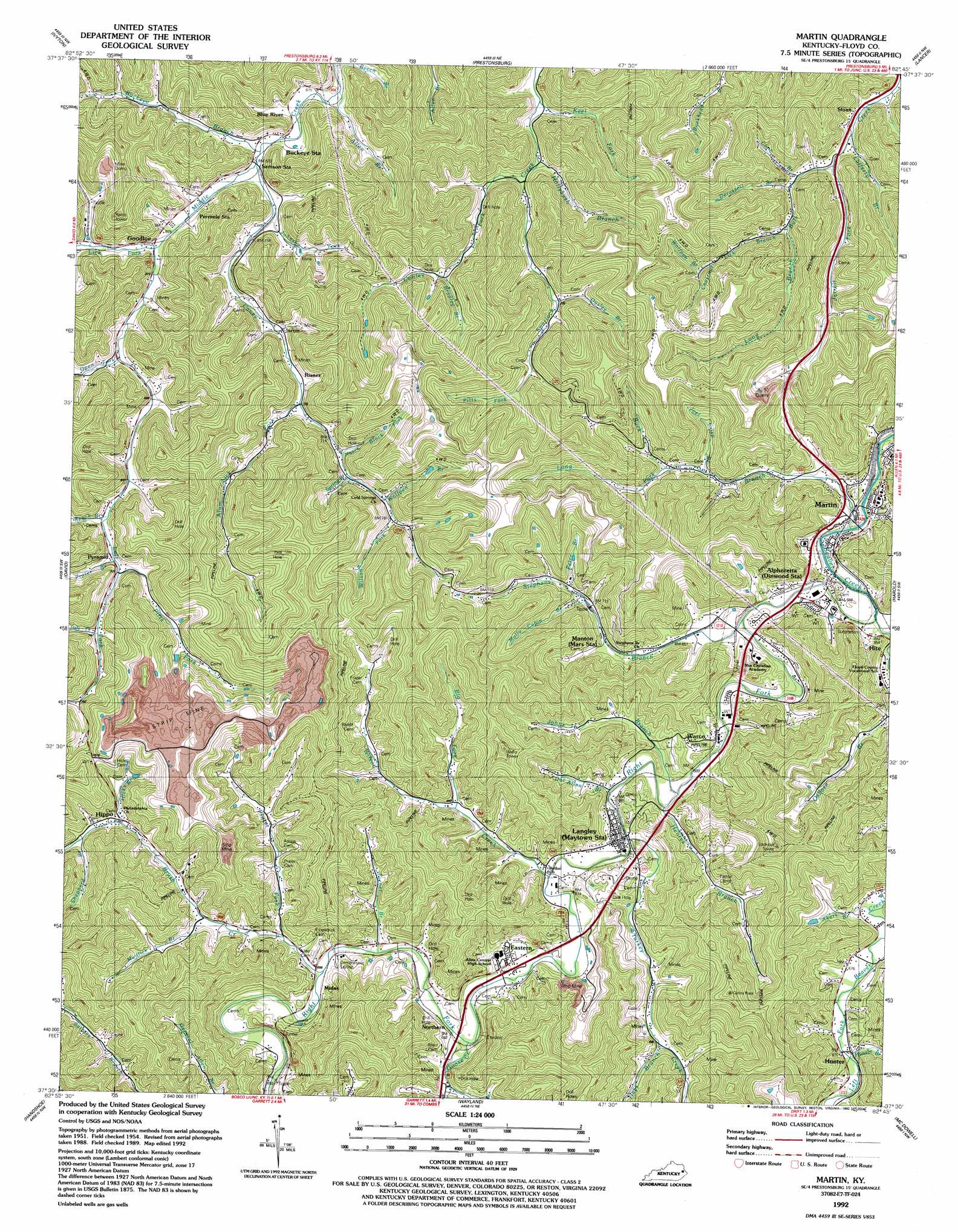
Martin Topo Map Kentucky
To zoom in, hover over the map of Martin
USGS Topo Quad 37082e7 - 1:24,000 scale
| Topo Map Name: | Martin |
| USGS Topo Quad ID: | 37082e7 |
| Print Size: | ca. 21 1/4" wide x 27" high |
| Southeast Coordinates: | 37.5° N latitude / 82.75° W longitude |
| Map Center Coordinates: | 37.5625° N latitude / 82.8125° W longitude |
| U.S. State: | KY |
| Filename: | o37082e7.jpg |
| Download Map JPG Image: | Martin topo map 1:24,000 scale |
| Map Type: | Topographic |
| Topo Series: | 7.5´ |
| Map Scale: | 1:24,000 |
| Source of Map Images: | United States Geological Survey (USGS) |
| Alternate Map Versions: |
Martin KY 1954, updated 1955 Download PDF Buy paper map Martin KY 1954, updated 1973 Download PDF Buy paper map Martin KY 1954, updated 1978 Download PDF Buy paper map Martin KY 1992, updated 1992 Download PDF Buy paper map Martin KY 2010 Download PDF Buy paper map Martin KY 2013 Download PDF Buy paper map Martin KY 2016 Download PDF Buy paper map |
1:24,000 Topo Quads surrounding Martin
Salyersville North |
Oil Springs |
Paintsville |
Offutt |
Inez |
Salyersville South |
Ivyton |
Prestonsburg |
Lancer |
Thomas |
Tiptop |
David |
Martin |
Harold |
Broad Bottom |
Vest |
Handshoe |
Wayland |
Mcdowell |
Pikeville |
Carrie |
Hindman |
Kite |
Wheelwright |
Dorton |
> Back to 37082e1 at 1:100,000 scale
> Back to 37082a1 at 1:250,000 scale
> Back to U.S. Topo Maps home
Martin topo map: Gazetteer
Martin: Pillars
Collins Rock elevation 478m 1568′Martin: Populated Places
Alphoretta elevation 210m 688′Blue River elevation 203m 666′
Eastern elevation 205m 672′
Goodloe elevation 218m 715′
Hippo elevation 227m 744′
Hite elevation 204m 669′
Hunter elevation 205m 672′
Langley elevation 200m 656′
Martin elevation 201m 659′
Midas elevation 216m 708′
Northern elevation 208m 682′
Pyramid elevation 218m 715′
Risner elevation 216m 708′
Sloan elevation 213m 698′
Warco elevation 201m 659′
Martin: Post Offices
Bob Post Office elevation 205m 672′Dock Post Office elevation 205m 672′
Fredville Post Office (historical) elevation 404m 1325′
Martin: Streams
Akers Branch elevation 201m 659′Allen Branch elevation 196m 643′
Alum Lick Fork elevation 215m 705′
Beech Branch elevation 214m 702′
Beech Branch elevation 194m 636′
Big Fork elevation 213m 698′
Bradley Branch elevation 231m 757′
Brush Creek elevation 202m 662′
Buck Branch elevation 195m 639′
Buckeye Branch elevation 201m 659′
Caney Creek elevation 201m 659′
Chestnut Lick Branch elevation 227m 744′
Conley Fork elevation 205m 672′
Conn Branch elevation 212m 695′
Derossett Branch elevation 215m 705′
Doc Allen Branch elevation 199m 652′
Goose Creek elevation 201m 659′
Gosling Branch elevation 214m 702′
Hale Fork elevation 227m 744′
Hays Branch elevation 216m 708′
Henrys Branch elevation 195m 639′
Hicks Fork elevation 220m 721′
Hollybush Branch elevation 205m 672′
Hollybush Fork elevation 238m 780′
Hunter Branch elevation 200m 656′
Hunter Branch elevation 208m 682′
Jarrell Fork elevation 206m 675′
Joel Crisp Branch elevation 212m 695′
Johns Branch elevation 195m 639′
Johnson Fork elevation 201m 659′
Keel Fork elevation 205m 672′
Lafferty School (historical) elevation 203m 666′
Left Fork Beaver Creek elevation 195m 639′
Lick Fork elevation 205m 672′
Long Branch elevation 227m 744′
Long Fork elevation 217m 711′
Molly Cabin Branch elevation 219m 718′
Mudlick Branch elevation 218m 715′
Notch Block Fork elevation 219m 718′
Oldhouse Branch elevation 320m 1049′
Open Fork elevation 207m 679′
Ousley Branch elevation 226m 741′
Peter Branch elevation 220m 721′
Pitts Fork elevation 219m 718′
Pitts Fork elevation 239m 784′
Prater Branch elevation 218m 715′
Prater Fork elevation 205m 672′
Reffett Branch elevation 239m 784′
Right Fork Beaver Creek elevation 195m 639′
Shepherd Branch elevation 229m 751′
Spring Branch elevation 224m 734′
Stephens Branch elevation 195m 639′
Turkey Creek elevation 195m 639′
Turner Branch elevation 206m 675′
Wilson Creek elevation 195m 639′
Wilson Fork elevation 238m 780′
Wolfpen Branch elevation 230m 754′
Wolfpen Branch elevation 252m 826′
Martin digital topo map on disk
Buy this Martin topo map showing relief, roads, GPS coordinates and other geographical features, as a high-resolution digital map file on DVD:
Western Virginia & Southern West Virginia
Buy digital topo maps: Western Virginia & Southern West Virginia