David Topo Map Kentucky
To zoom in, hover over the map of David
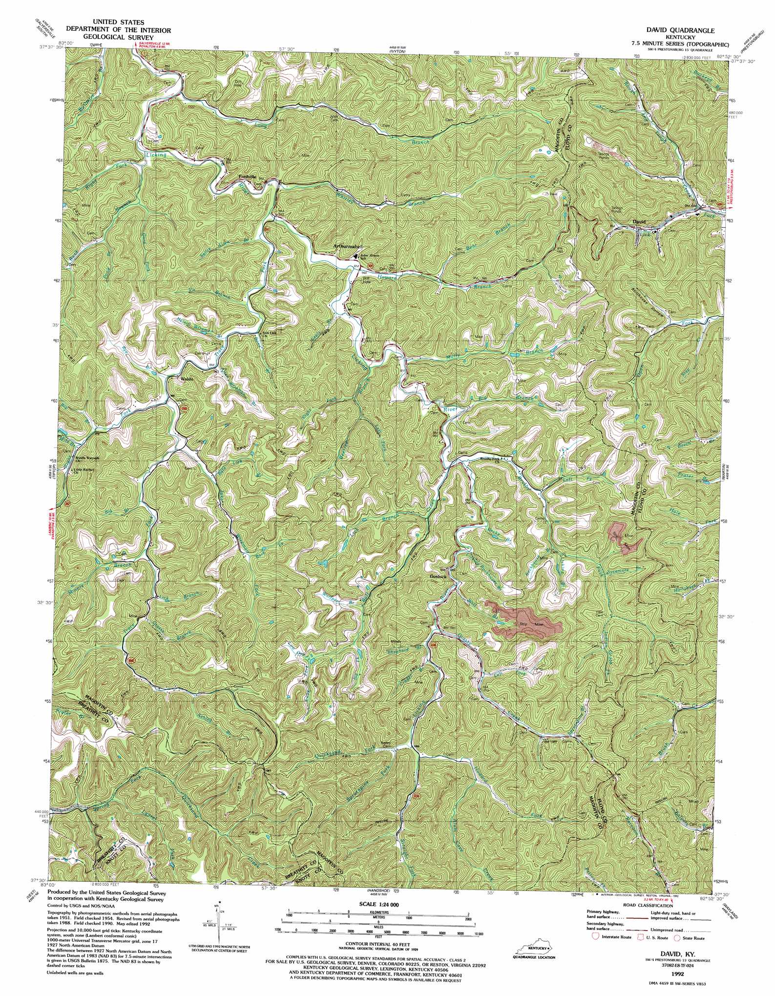
USGS Topo Quad 37082e8 - 1:24,000 scale
| Topo Map Name: | David |
| USGS Topo Quad ID: | 37082e8 |
| Print Size: | ca. 21 1/4" wide x 27" high |
| Southeast Coordinates: | 37.5° N latitude / 82.875° W longitude |
| Map Center Coordinates: | 37.5625° N latitude / 82.9375° W longitude |
| U.S. State: | KY |
| Filename: | o37082e8.jpg |
| Download Map JPG Image: | David topo map 1:24,000 scale |
| Map Type: | Topographic |
| Topo Series: | 7.5´ |
| Map Scale: | 1:24,000 |
| Source of Map Images: | United States Geological Survey (USGS) |
| Alternate Map Versions: |
David KY 1954, updated 1956 Download PDF Buy paper map David KY 1954, updated 1970 Download PDF Buy paper map David KY 1954, updated 1979 Download PDF Buy paper map David KY 1992, updated 1992 Download PDF Buy paper map David KY 2010 Download PDF Buy paper map David KY 2013 Download PDF Buy paper map David KY 2016 Download PDF Buy paper map |
1:24,000 Topo Quads surrounding David
White Oak |
Salyersville North |
Oil Springs |
Paintsville |
Offutt |
Seitz |
Salyersville South |
Ivyton |
Prestonsburg |
Lancer |
Guage |
Tiptop |
David |
Martin |
Harold |
Noble |
Vest |
Handshoe |
Wayland |
Mcdowell |
Hazard North |
Carrie |
Hindman |
Kite |
Wheelwright |
> Back to 37082e1 at 1:100,000 scale
> Back to 37082a1 at 1:250,000 scale
> Back to U.S. Topo Maps home
David topo map: Gazetteer
David: Bridges
White Bridge elevation 293m 961′David: Populated Places
Arthurmabel elevation 308m 1010′David elevation 216m 708′
Fredville elevation 290m 951′
Gunlock elevation 305m 1000′
Waldo elevation 300m 984′
David: Post Offices
Gypsy Post Office (historical) elevation 392m 1286′Mid Post Office (historical) elevation 295m 967′
Orchard Post Office (historical) elevation 299m 980′
Ordway Post Office (historical) elevation 340m 1115′
Waldo Post Office (historical) elevation 287m 941′
David: Springs
Sulfur Springs elevation 311m 1020′David: Streams
Allen Wireman Branch elevation 288m 944′Alum Cave Creek elevation 315m 1033′
Ashlog Branch elevation 327m 1072′
Barb Fork elevation 309m 1013′
Bate Lick Branch elevation 295m 967′
Bear Branch elevation 296m 971′
Becky Branch elevation 303m 994′
Beetree Branch elevation 288m 944′
Big Branch elevation 304m 997′
Big Branch elevation 292m 958′
Big Branch elevation 302m 990′
Bone Branch elevation 286m 938′
Brushy Fork elevation 296m 971′
Buck Branch elevation 280m 918′
Bull Creek elevation 294m 964′
Crager Branch elevation 301m 987′
Gard Fork elevation 289m 948′
Grassy Branch elevation 304m 997′
Grassy Creek elevation 298m 977′
Howard Branch elevation 286m 938′
Howard Fork elevation 315m 1033′
Indian Grave Fork elevation 337m 1105′
Ivy Fork elevation 324m 1062′
Jake Wiremen Fork elevation 291m 954′
Laurel Fork elevation 327m 1072′
Left Fork Beetree Branch elevation 298m 977′
Left Fork Brushy Fork elevation 297m 974′
Left Fork Grassy Creek elevation 315m 1033′
Lick Branch elevation 304m 997′
Lick Branch elevation 302m 990′
Licking Branch elevation 305m 1000′
Licking Rockhouse Branch elevation 310m 1017′
Long Branch elevation 280m 918′
Long Fork elevation 324m 1062′
Low Gap Fork elevation 338m 1108′
Mile Branch elevation 301m 987′
Minnix Branch elevation 301m 987′
Molly Branch elevation 293m 961′
Nelvin Wireman Branch elevation 288m 944′
Open Fork elevation 298m 977′
Pond Branch elevation 289m 948′
Quicksand Fork elevation 308m 1010′
Right Fork Beetree Branch elevation 293m 961′
Right Fork Buck Branch elevation 280m 918′
Right Fork Trace Fork elevation 291m 954′
Rockhouse Branch elevation 300m 984′
Rough and Tough Creek elevation 207m 679′
Rye Branch elevation 290m 951′
Sallie Allen Branch elevation 287m 941′
Seals Branch elevation 287m 941′
Shepherd Branch elevation 300m 984′
Sprucepine Branch elevation 335m 1099′
Sprucepine Fork elevation 312m 1023′
Stay Creek elevation 212m 695′
Straight Fork elevation 308m 1010′
Sulphur Spring Branch elevation 329m 1079′
Sycamore Branch elevation 315m 1033′
Trace Fork elevation 282m 925′
Vic Branch elevation 286m 938′
Whitley Branch elevation 280m 918′
Wild Cat Branch elevation 297m 974′
Will Branch elevation 301m 987′
Wolfpen Branch elevation 317m 1040′
David: Valleys
Colt Hollow elevation 296m 971′Ella Hollow elevation 354m 1161′
Happy Hollow (historical) elevation 207m 679′
Lovely Hollow elevation 289m 948′
Stillhouse Hollow elevation 218m 715′
Sulfer Springs Hollow elevation 314m 1030′
David digital topo map on disk
Buy this David topo map showing relief, roads, GPS coordinates and other geographical features, as a high-resolution digital map file on DVD:
Western Virginia & Southern West Virginia
Buy digital topo maps: Western Virginia & Southern West Virginia