Barnabus Topo Map West Virginia
To zoom in, hover over the map of Barnabus
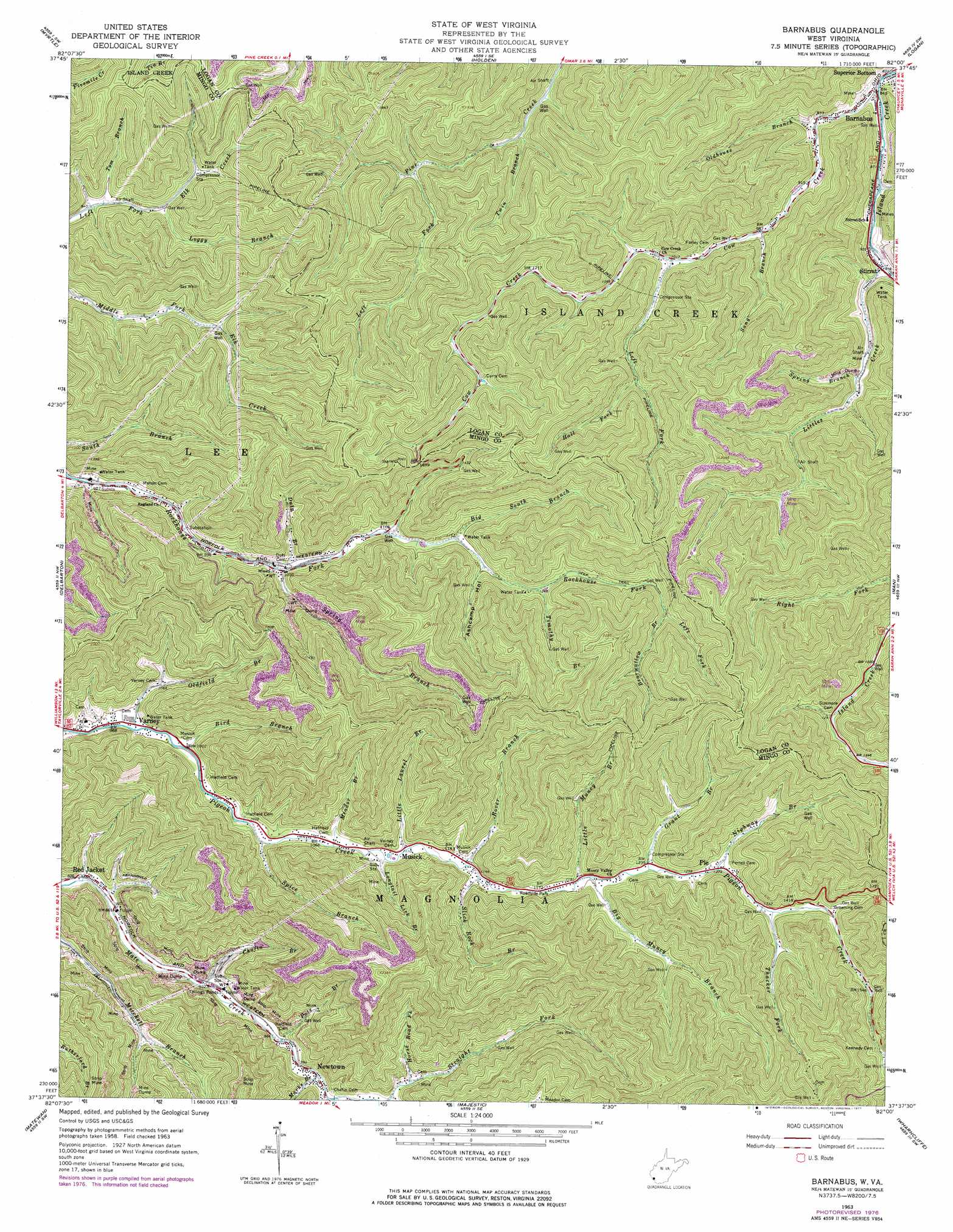
USGS Topo Quad 37082f1 - 1:24,000 scale
| Topo Map Name: | Barnabus |
| USGS Topo Quad ID: | 37082f1 |
| Print Size: | ca. 21 1/4" wide x 27" high |
| Southeast Coordinates: | 37.625° N latitude / 82° W longitude |
| Map Center Coordinates: | 37.6875° N latitude / 82.0625° W longitude |
| U.S. State: | WV |
| Filename: | o37082f1.jpg |
| Download Map JPG Image: | Barnabus topo map 1:24,000 scale |
| Map Type: | Topographic |
| Topo Series: | 7.5´ |
| Map Scale: | 1:24,000 |
| Source of Map Images: | United States Geological Survey (USGS) |
| Alternate Map Versions: |
Barnabus WV 1963, updated 1965 Download PDF Buy paper map Barnabus WV 1963, updated 1977 Download PDF Buy paper map Barnabus WV 1996, updated 2002 Download PDF Buy paper map Barnabus WV 2011 Download PDF Buy paper map Barnabus WV 2014 Download PDF Buy paper map Barnabus WV 2016 Download PDF Buy paper map |
1:24,000 Topo Quads surrounding Barnabus
Wilsondale |
Trace |
Chapmanville |
Henlawson |
Clothier |
Naugatuck |
Myrtle |
Holden |
Logan |
Amherstdale |
Williamson |
Delbarton |
Barnabus |
Man |
Mallory |
Belfry |
Matewan |
Majestic |
Wharncliffe |
Gilbert |
Lick Creek |
Jamboree |
Hurley |
Panther |
Iaeger |
> Back to 37082e1 at 1:100,000 scale
> Back to 37082a1 at 1:250,000 scale
> Back to U.S. Topo Maps home
Barnabus topo map: Gazetteer
Barnabus: Dams
Chafin Branch Dam elevation 455m 1492′National Refuse Dump Number 25 Dam elevation 410m 1345′
Barnabus: Populated Places
Barnabus elevation 265m 869′Calico elevation 466m 1528′
Musick elevation 335m 1099′
Newtown elevation 309m 1013′
Oilville elevation 324m 1062′
Pie elevation 386m 1266′
Stirrat elevation 278m 912′
Varney elevation 292m 958′
Barnabus: Post Offices
Newtown Post Office elevation 300m 984′Barnabus: Reservoirs
National Refuse Dump Number 25 elevation 410m 1345′Red Jacket Impoundment elevation 455m 1492′
Barnabus: Streams
Bearwallow Branch elevation 449m 1473′Big Muncy Branch elevation 364m 1194′
Big Pigeonroost Branch elevation 276m 905′
Big South Branch elevation 351m 1151′
Bird Branch elevation 304m 997′
Chafin Branch elevation 278m 912′
Cow Creek elevation 256m 839′
Cynthia Branch elevation 312m 1023′
Double Camp Fork elevation 314m 1030′
Duty Branch elevation 314m 1030′
Grant Branch elevation 372m 1220′
Hall Fork elevation 379m 1243′
Horse Road Fork elevation 356m 1167′
Left Fork Cow Creek elevation 311m 1020′
Left Fork Pine Creek elevation 346m 1135′
Left Fork Rockhouse Fork elevation 449m 1473′
Little Laurel Branch elevation 336m 1102′
Little Muncy Branch elevation 361m 1184′
Littles Creek elevation 278m 912′
Loggy Branch elevation 305m 1000′
Longtail Lick Branch elevation 333m 1092′
Marks Branch elevation 311m 1020′
Meador Branch elevation 325m 1066′
Nighway Branch elevation 396m 1299′
Oldfield Branch elevation 296m 971′
Oldhouse Branch elevation 269m 882′
Pats Branch elevation 298m 977′
Rover Branch elevation 344m 1128′
Sang Branch elevation 292m 958′
Slick Rock Branch elevation 345m 1131′
Spice Branch elevation 317m 1040′
Spring Branch elevation 312m 1023′
Spring Branch elevation 319m 1046′
Thacker Fork elevation 403m 1322′
Timothy Branch elevation 377m 1236′
Tom Branch elevation 290m 951′
Twin Branch elevation 321m 1053′
Barnabus: Valleys
Ashcamp Hollow elevation 361m 1184′Barnabus digital topo map on disk
Buy this Barnabus topo map showing relief, roads, GPS coordinates and other geographical features, as a high-resolution digital map file on DVD:
Western Virginia & Southern West Virginia
Buy digital topo maps: Western Virginia & Southern West Virginia