Williamson Topo Map Kentucky
To zoom in, hover over the map of Williamson
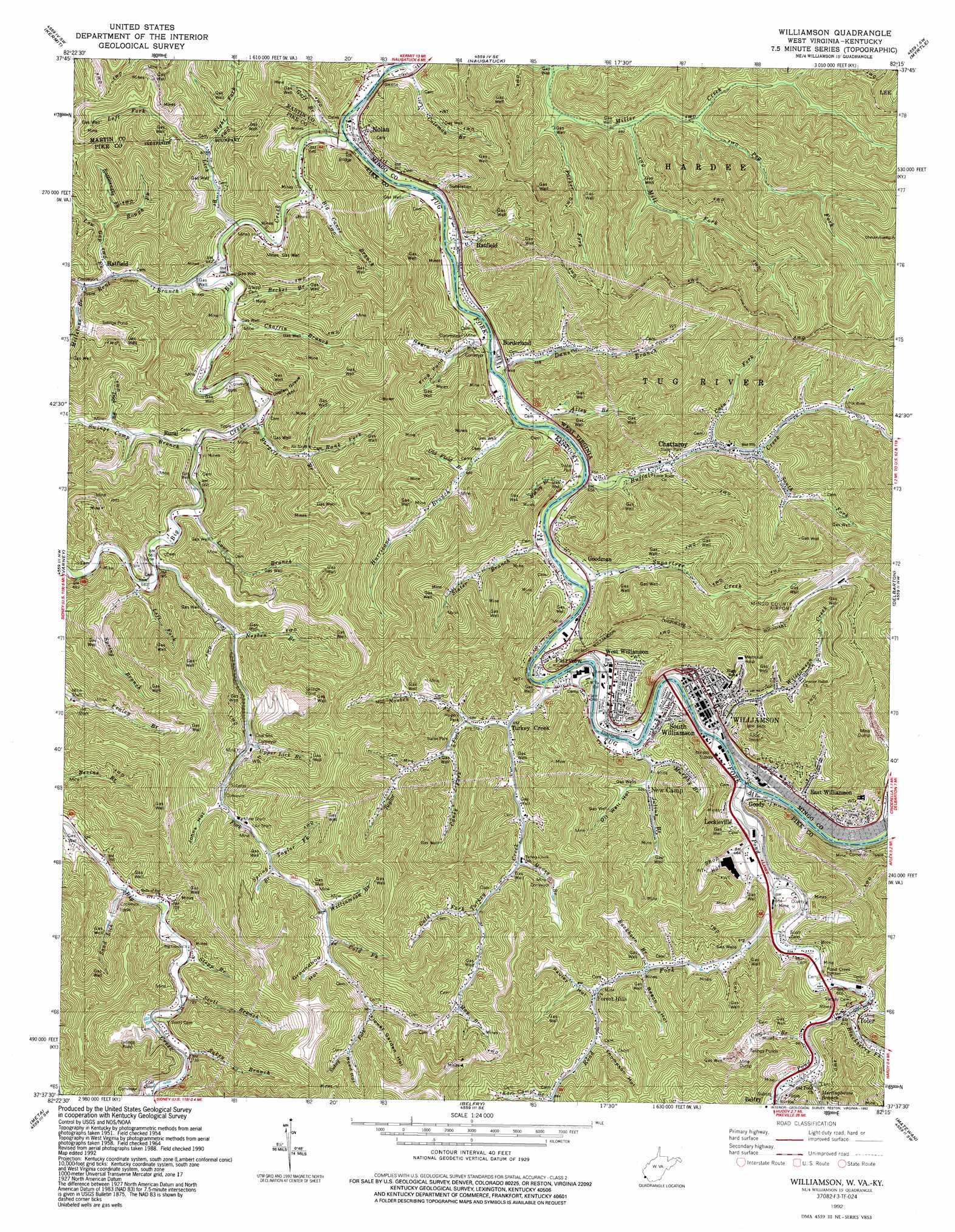
USGS Topo Quad 37082f3 - 1:24,000 scale
| Topo Map Name: | Williamson |
| USGS Topo Quad ID: | 37082f3 |
| Print Size: | ca. 21 1/4" wide x 27" high |
| Southeast Coordinates: | 37.625° N latitude / 82.25° W longitude |
| Map Center Coordinates: | 37.6875° N latitude / 82.3125° W longitude |
| U.S. States: | KY, WV |
| Filename: | o37082f3.jpg |
| Download Map JPG Image: | Williamson topo map 1:24,000 scale |
| Map Type: | Topographic |
| Topo Series: | 7.5´ |
| Map Scale: | 1:24,000 |
| Source of Map Images: | United States Geological Survey (USGS) |
| Alternate Map Versions: |
Williamson WV 1954, updated 1955 Download PDF Buy paper map Williamson WV 1954, updated 1955 Download PDF Buy paper map Williamson WV 1964, updated 1965 Download PDF Buy paper map Williamson WV 1964, updated 1972 Download PDF Buy paper map Williamson WV 1964, updated 1978 Download PDF Buy paper map Williamson WV 1964, updated 1991 Download PDF Buy paper map Williamson WV 1992, updated 1992 Download PDF Buy paper map Williamson WV 2011 Download PDF Buy paper map Williamson WV 2014 Download PDF Buy paper map Williamson WV 2016 Download PDF Buy paper map |
1:24,000 Topo Quads surrounding Williamson
Milo |
Webb |
Wilsondale |
Trace |
Chapmanville |
Inez |
Kermit |
Naugatuck |
Myrtle |
Holden |
Thomas |
Varney |
Williamson |
Delbarton |
Barnabus |
Broad Bottom |
Meta |
Belfry |
Matewan |
Majestic |
Pikeville |
Millard |
Lick Creek |
Jamboree |
Hurley |
> Back to 37082e1 at 1:100,000 scale
> Back to 37082a1 at 1:250,000 scale
> Back to U.S. Topo Maps home
Williamson topo map: Gazetteer
Williamson: Airports
Mingo County Airport elevation 439m 1440′Williamson: Parks
Rogers Park elevation 237m 777′Williamson: Populated Places
Borderland elevation 199m 652′Chattaroy elevation 202m 662′
East Williamson elevation 201m 659′
Fairview elevation 201m 659′
Forest Hills elevation 237m 777′
Goodman elevation 198m 649′
Goody elevation 207m 679′
Hatfield elevation 215m 705′
Hatfield elevation 200m 656′
Leckieville elevation 204m 669′
Mouth of Long Fork elevation 203m 666′
New Camp elevation 221m 725′
Nolan elevation 197m 646′
Road Fork elevation 243m 797′
Rural elevation 205m 672′
Slatter Branch elevation 211m 692′
South Williamson elevation 202m 662′
Toler elevation 207m 679′
Turkey Creek elevation 200m 656′
Victoria Court elevation 201m 659′
West Williamson elevation 199m 652′
Williamson elevation 200m 656′
Williamson Terrace elevation 232m 761′
Williamson: Post Offices
Borderland Post Office elevation 207m 679′Burris Post Office (historical) elevation 230m 754′
Chattaroy Post Office elevation 201m 659′
Goody Post Office (historical) elevation 205m 672′
Hatfield Post Office (historical) elevation 210m 688′
Mouth of Pond Post Office (historical) elevation 198m 649′
Nolan Post Office elevation 200m 656′
Runyon Post Office (historical) elevation 204m 669′
Rural Post Office (historical) elevation 201m 659′
Turkey Creek Post Office (historical) elevation 198m 649′
White Post Office (historical) elevation 198m 649′
Williamson Post Office elevation 200m 656′
Williamson: Streams
Alley Branch elevation 188m 616′Becket Branch elevation 192m 629′
Bent Branch elevation 192m 629′
Big Canoe Branch elevation 186m 610′
Big Creek elevation 185m 606′
Blackberry Fork elevation 202m 662′
Buckhorn Branch elevation 227m 744′
Buffalo Creek elevation 195m 639′
Burgett Branch elevation 194m 636′
Cain Fork elevation 224m 734′
Caney Fork elevation 217m 711′
Chaffin Branch elevation 194m 636′
Cold Fork elevation 279m 915′
Cold Fork elevation 241m 790′
Coleman Branch elevation 197m 646′
Cow Branch elevation 209m 685′
Dans Branch elevation 188m 616′
Dick Fork elevation 215m 705′
Goff Branch elevation 198m 649′
Hurricane Branch elevation 188m 616′
Julius Branch elevation 190m 623′
Kate Camp Branch elevation 263m 862′
Left Fork Lick Branch elevation 204m 669′
Left Fork Miller Creek elevation 202m 662′
Left Fork Spring Branch elevation 206m 675′
Lick Branch elevation 192m 629′
Long Fork elevation 206m 675′
Low Gap Fork elevation 215m 705′
Lowe Branch elevation 195m 639′
Lower Lick Branch elevation 227m 744′
May Branch elevation 284m 931′
McCoy Branch elevation 189m 620′
Meetinghouse Branch elevation 207m 679′
Mill Fork elevation 210m 688′
Millstone Branch elevation 217m 711′
Money Branch elevation 225m 738′
Murphy Branch elevation 201m 659′
Nosben Branch elevation 215m 705′
Nosben Fork elevation 203m 666′
Old Field Branch elevation 220m 721′
Parker Fork elevation 204m 669′
Peg Fork elevation 222m 728′
Pond Creek elevation 190m 623′
Rank Fork elevation 335m 1099′
Rattlesnake Fork elevation 243m 797′
Right Fork Lick Branch elevation 205m 672′
Road Fork elevation 196m 643′
Rough Fork elevation 228m 748′
Sand Lick elevation 211m 692′
Scott Branch elevation 219m 718′
Slater Branch elevation 192m 629′
South Fork Buffalo Creek elevation 213m 698′
Spring Branch elevation 254m 833′
Spring Branch elevation 208m 682′
Stepp Branch elevation 219m 718′
Sugartree Creek elevation 190m 623′
Sukey Branch elevation 219m 718′
Sukey Fork elevation 300m 984′
Swinge Camp Branch elevation 194m 636′
Taylor Fork elevation 253m 830′
Taylor Fork elevation 207m 679′
Turkey Creek elevation 190m 623′
Upper Lick Branch elevation 229m 751′
Williamson Branch elevation 269m 882′
Williamson Creek elevation 219m 718′
Williamson: Tunnels
Pond Creek Tunnel elevation 236m 774′Williamson: Valleys
Beech Hollow elevation 229m 751′Flower Garden Hollow elevation 306m 1003′
Frog Pond Hollow elevation 202m 662′
Groundhog Hollow elevation 287m 941′
Indian Grave Hollow elevation 211m 692′
Johns Hollow elevation 241m 790′
Negro Hollow elevation 229m 751′
Oil Well Hollow elevation 209m 685′
Pauley Hollow elevation 260m 853′
Pauley Hollow elevation 255m 836′
Reed Hollow elevation 323m 1059′
Shop Hollow elevation 203m 666′
Thompson Hollow elevation 255m 836′
Williamson digital topo map on disk
Buy this Williamson topo map showing relief, roads, GPS coordinates and other geographical features, as a high-resolution digital map file on DVD:
Western Virginia & Southern West Virginia
Buy digital topo maps: Western Virginia & Southern West Virginia