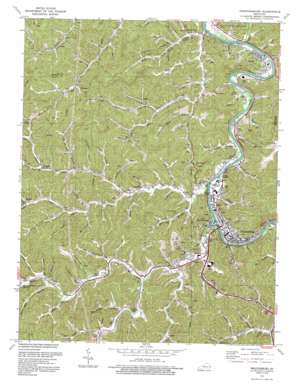
Prestonsburg Topo Map Kentucky
To zoom in, hover over the map of Prestonsburg
USGS Topo Quad 37082f7 - 1:24,000 scale
| Topo Map Name: | Prestonsburg |
| USGS Topo Quad ID: | 37082f7 |
| Print Size: | ca. 21 1/4" wide x 27" high |
| Southeast Coordinates: | 37.625° N latitude / 82.75° W longitude |
| Map Center Coordinates: | 37.6875° N latitude / 82.8125° W longitude |
| U.S. State: | KY |
| Filename: | o37082f7.jpg |
| Download Map JPG Image: | Prestonsburg topo map 1:24,000 scale |
| Map Type: | Topographic |
| Topo Series: | 7.5´ |
| Map Scale: | 1:24,000 |
| Source of Map Images: | United States Geological Survey (USGS) |
| Alternate Map Versions: |
Prestonsburg KY 1954, updated 1956 Download PDF Buy paper map Prestonsburg KY 1962, updated 1964 Download PDF Buy paper map Prestonsburg KY 1978, updated 1978 Download PDF Buy paper map Prestonsburg KY 1992, updated 1992 Download PDF Buy paper map Prestonsburg KY 2010 Download PDF Buy paper map Prestonsburg KY 2013 Download PDF Buy paper map Prestonsburg KY 2016 Download PDF Buy paper map |
1:24,000 Topo Quads surrounding Prestonsburg
> Back to 37082e1 at 1:100,000 scale
> Back to 37082a1 at 1:250,000 scale
> Back to U.S. Topo Maps home
Prestonsburg topo map: Gazetteer
Prestonsburg: Airports
Paintsville-Prestonsburg/Combs Field elevation 190m 623′Prestonsburg: Parks
Archer Park elevation 181m 593′Prestonsburg: Populated Places
Auxier elevation 188m 616′Bays Branch elevation 191m 626′
Bonanza elevation 208m 682′
Cliff elevation 190m 623′
Dotson elevation 207m 679′
East Point elevation 194m 636′
Prestonsburg elevation 193m 633′
West Prestonsburg elevation 187m 613′
Whitaker elevation 259m 849′
Prestonsburg: Post Offices
Fitzpatrick Post Office elevation 194m 636′West Prestonsburg Post Office elevation 188m 616′
Prestonsburg: Streams
Abbott Creek elevation 182m 597′Allen Branch elevation 192m 629′
Alley Fork elevation 194m 636′
Arnett Branch elevation 205m 672′
Auxier Branch elevation 182m 597′
Bays Branch elevation 182m 597′
Bee Fork elevation 207m 679′
Big Branch elevation 191m 626′
Blue River Branch elevation 191m 626′
Bob Fitzpatrick Branch elevation 194m 636′
Buckhead Branch elevation 220m 721′
Conley Fork elevation 219m 718′
Copperas Lick Branch elevation 203m 666′
Davis Branch elevation 217m 711′
Duck Hole Branch elevation 198m 649′
Elliott Branch elevation 192m 629′
Friend Branch elevation 187m 613′
Fryleys Branch elevation 182m 597′
George Branch elevation 205m 672′
Granny Fitz Branch elevation 203m 666′
Greer Branch elevation 212m 695′
Hackworth Branch elevation 198m 649′
Hager Branch elevation 190m 623′
Hale Branch elevation 216m 708′
Holbrook Branch elevation 196m 643′
Hunter Branch elevation 193m 633′
Ike Fitzpatrick Branch elevation 182m 597′
Jack Arnett Branch elevation 203m 666′
Jane Brown Branch elevation 180m 590′
Jim Potter Branch elevation 194m 636′
Jim Ward Branch elevation 182m 597′
Johns Creek elevation 182m 597′
Left Fork Little Paint Creek elevation 217m 711′
Left Fork Middle Creek Levisa Fork elevation 189m 620′
Lick Branch elevation 182m 597′
Little Abbott Creek elevation 193m 633′
Little Paint Creek elevation 181m 593′
Long Branch elevation 197m 646′
Mart Meade Branch elevation 201m 659′
May Branch elevation 183m 600′
Meade Branch elevation 191m 626′
Meadow Branch elevation 196m 643′
Middle Creek Levisa Fork elevation 181m 593′
Mill Branch elevation 203m 666′
Mullin Branch elevation 203m 666′
Music Fork elevation 235m 770′
Neely Branch elevation 204m 669′
Osborn Branch elevation 191m 626′
Potts Branch elevation 191m 626′
Prater Fork elevation 219m 718′
Puckett Fork elevation 221m 725′
Right Fork Bull Creek elevation 203m 666′
Right Fork Little Paint Creek elevation 217m 711′
Road Branch elevation 247m 810′
Rough and Tough Branch elevation 205m 672′
Sally Stevens Branch elevation 183m 600′
Sally Stout Branch elevation 193m 633′
Sam Hale Branch elevation 195m 639′
Shop Branch elevation 204m 669′
Short Branch elevation 209m 685′
Shot Gun Hollow elevation 191m 626′
Spradlin Branch elevation 182m 597′
Spurlock Creek elevation 180m 590′
State Road Fork elevation 193m 633′
Stephens Branch elevation 181m 593′
Steve Fitzpatrick Branch elevation 193m 633′
Town Branch elevation 212m 695′
Trimble Branch elevation 184m 603′
Wallen Fork elevation 209m 685′
William Branch elevation 205m 672′
Workman Branch elevation 191m 626′
Prestonsburg: Valleys
Bear Hollow elevation 179m 587′Jockey Hollow elevation 192m 629′
Kelse Hollow elevation 194m 636′
Pin Hollow elevation 198m 649′
Stumbo Hollow elevation 183m 600′
Travis Hollow elevation 206m 675′
Prestonsburg digital topo map on disk
Buy this Prestonsburg topo map showing relief, roads, GPS coordinates and other geographical features, as a high-resolution digital map file on DVD:
Western Virginia & Southern West Virginia
Buy digital topo maps: Western Virginia & Southern West Virginia


