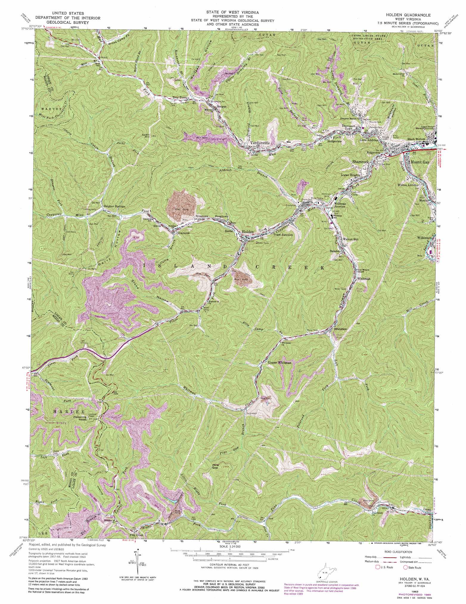
Holden Topo Map West Virginia
To zoom in, hover over the map of Holden
USGS Topo Quad 37082g1 - 1:24,000 scale
| Topo Map Name: | Holden |
| USGS Topo Quad ID: | 37082g1 |
| Print Size: | ca. 21 1/4" wide x 27" high |
| Southeast Coordinates: | 37.75° N latitude / 82° W longitude |
| Map Center Coordinates: | 37.8125° N latitude / 82.0625° W longitude |
| U.S. State: | WV |
| Filename: | o37082g1.jpg |
| Download Map JPG Image: | Holden topo map 1:24,000 scale |
| Map Type: | Topographic |
| Topo Series: | 7.5´ |
| Map Scale: | 1:24,000 |
| Source of Map Images: | United States Geological Survey (USGS) |
| Alternate Map Versions: |
Holden WV 1963, updated 1964 Download PDF Buy paper map Holden WV 1963, updated 1977 Download PDF Buy paper map Holden WV 1963, updated 1989 Download PDF Buy paper map Holden WV 1996, updated 2002 Download PDF Buy paper map Holden WV 2010 Download PDF Buy paper map Holden WV 2014 Download PDF Buy paper map Holden WV 2016 Download PDF Buy paper map |
1:24,000 Topo Quads surrounding Holden
Kiahsville |
Ranger |
Big Creek |
Mud |
Madison |
Wilsondale |
Trace |
Chapmanville |
Henlawson |
Clothier |
Naugatuck |
Myrtle |
Holden |
Logan |
Amherstdale |
Williamson |
Delbarton |
Barnabus |
Man |
Mallory |
Belfry |
Matewan |
Majestic |
Wharncliffe |
Gilbert |
> Back to 37082e1 at 1:100,000 scale
> Back to 37082a1 at 1:250,000 scale
> Back to U.S. Topo Maps home
Holden topo map: Gazetteer
Holden: Dams
Mud Fork Refuse Dam elevation 312m 1023′Holden: Gaps
Pine Gap elevation 457m 1499′Holden: Populated Places
Baisden elevation 269m 882′Beebe elevation 225m 738′
Black Bottom elevation 219m 718′
Bradshaw elevation 248m 813′
City View Addition elevation 243m 797′
Cora elevation 225m 738′
Davis elevation 244m 800′
Diamond elevation 243m 797′
Frogtown elevation 228m 748′
Hedgeview elevation 249m 816′
Holden elevation 224m 734′
Lintz Addition elevation 247m 810′
Logan Heights elevation 211m 692′
Monitor elevation 220m 721′
Mount Gay elevation 205m 672′
Pine Creek elevation 350m 1148′
Ridgeview elevation 222m 728′
Shamrock elevation 239m 784′
Shegon elevation 252m 826′
Sulphur Springs elevation 251m 823′
Sycamore elevation 258m 846′
Thompson Town elevation 260m 853′
Trace Junction elevation 256m 839′
Troy Town elevation 292m 958′
Upper Whitman elevation 285m 935′
Verdunville elevation 268m 879′
Walnut Hill elevation 222m 728′
Whites Addition elevation 249m 816′
Whitman elevation 240m 787′
Whitman Junction elevation 210m 688′
Holden: Post Offices
Mount Gay Post Office elevation 213m 698′Verdunville Post Office elevation 224m 734′
Whitman Post Office elevation 225m 738′
Holden: Reservoirs
Mud Fork Impoundment elevation 312m 1023′Holden: Streams
Aldrich Branch elevation 277m 908′Big Branch elevation 277m 908′
Brush Camp Fork elevation 282m 925′
Cabin Branch elevation 258m 846′
Copperas Mine Fork elevation 283m 928′
Copperas Rock Branch elevation 247m 810′
Curry Branch elevation 240m 787′
Dingess Fork elevation 264m 866′
Ellis Branch elevation 237m 777′
Ellis Camp Branch elevation 298m 977′
Jacks Fork elevation 280m 918′
Laurel Fork elevation 366m 1200′
Left Fork Whitman Creek elevation 243m 797′
Lefthand Branch Mud Fork elevation 234m 767′
Little Right Fork elevation 305m 1000′
Lower Dempsey Branch elevation 257m 843′
Mill Branch elevation 277m 908′
Mud Fork elevation 236m 774′
Orchard Branch elevation 250m 820′
Pine Creek elevation 246m 807′
Pine Gap Branch elevation 294m 964′
Poleroad Fork elevation 271m 889′
Right Fork Pine Creek elevation 294m 964′
Right Hand Branch elevation 277m 908′
Rockhouse Branch elevation 303m 994′
Simmons Fork elevation 296m 971′
Skifus Branch elevation 273m 895′
Tin Branch elevation 366m 1200′
Trace Fork elevation 228m 748′
Upper Dempsey Branch elevation 260m 853′
Whitman Creek elevation 211m 692′
Holden: Summits
Cabin Hill elevation 537m 1761′Pickering Knob elevation 587m 1925′
Holden: Valleys
Dairy Hollow elevation 252m 826′Milkhouse Hollow elevation 203m 666′
Stone Hollow elevation 280m 918′
Wolfpen Hollow elevation 262m 859′
Holden digital topo map on disk
Buy this Holden topo map showing relief, roads, GPS coordinates and other geographical features, as a high-resolution digital map file on DVD:
Western Virginia & Southern West Virginia
Buy digital topo maps: Western Virginia & Southern West Virginia