Trace Topo Map West Virginia
To zoom in, hover over the map of Trace
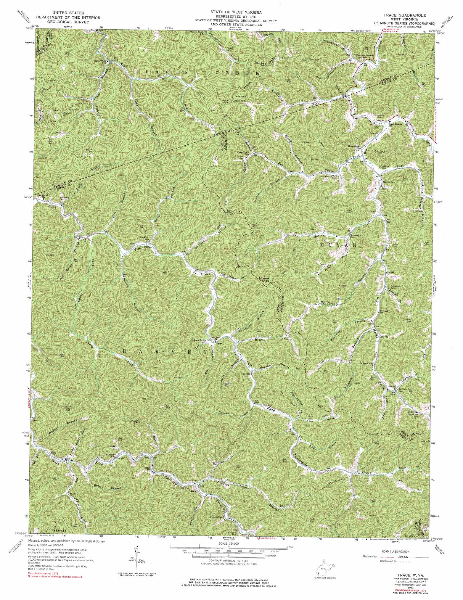
USGS Topo Quad 37082h2 - 1:24,000 scale
| Topo Map Name: | Trace |
| USGS Topo Quad ID: | 37082h2 |
| Print Size: | ca. 21 1/4" wide x 27" high |
| Southeast Coordinates: | 37.875° N latitude / 82.125° W longitude |
| Map Center Coordinates: | 37.9375° N latitude / 82.1875° W longitude |
| U.S. State: | WV |
| Filename: | o37082h2.jpg |
| Download Map JPG Image: | Trace topo map 1:24,000 scale |
| Map Type: | Topographic |
| Topo Series: | 7.5´ |
| Map Scale: | 1:24,000 |
| Source of Map Images: | United States Geological Survey (USGS) |
| Alternate Map Versions: |
Trace WV 1963, updated 1964 Download PDF Buy paper map Trace WV 1963, updated 1977 Download PDF Buy paper map Trace WV 1997, updated 2003 Download PDF Buy paper map Trace WV 2011 Download PDF Buy paper map Trace WV 2014 Download PDF Buy paper map Trace WV 2016 Download PDF Buy paper map |
1:24,000 Topo Quads surrounding Trace
Wayne |
Nestlow |
Branchland |
Hager |
Griffithsville |
Radnor |
Kiahsville |
Ranger |
Big Creek |
Mud |
Webb |
Wilsondale |
Trace |
Chapmanville |
Henlawson |
Kermit |
Naugatuck |
Myrtle |
Holden |
Logan |
Varney |
Williamson |
Delbarton |
Barnabus |
Man |
> Back to 37082e1 at 1:100,000 scale
> Back to 37082a1 at 1:250,000 scale
> Back to U.S. Topo Maps home
Trace topo map: Gazetteer
Trace: Populated Places
Kirk elevation 266m 872′McCloud elevation 269m 882′
Trace elevation 283m 928′
Whirlwind elevation 222m 728′
Trace: Ridges
Bryan Ridge elevation 402m 1318′Trace: Streams
Adams Branch elevation 217m 711′Alex Branch elevation 246m 807′
Andy Branch elevation 241m 790′
Bailey Branch elevation 268m 879′
Barker Branch elevation 277m 908′
Big Branch elevation 265m 869′
Big Sang Kill elevation 264m 866′
Bills Branch elevation 268m 879′
Blair Fork elevation 321m 1053′
Boardtree Branch elevation 219m 718′
Brier Branch elevation 245m 803′
Buck Fork elevation 199m 652′
Bulwark Branch elevation 221m 725′
Camp Branch elevation 290m 951′
Caney Fork elevation 242m 793′
Carter Branch elevation 215m 705′
Copley Branch elevation 246m 807′
Dingess Trace Branch elevation 280m 918′
Henderson Branch elevation 211m 692′
Hogger Branch elevation 266m 872′
Hogger Run elevation 276m 905′
Hoover Fork elevation 204m 669′
Hurricane Branch elevation 266m 872′
Ivy Branch elevation 243m 797′
Jims Branch elevation 252m 826′
Lambert Branch elevation 214m 702′
Left Hand Fork Hoover Fork elevation 217m 711′
Lick Branch elevation 292m 958′
Little Sang Kill elevation 268m 879′
Log Branch elevation 263m 862′
Marcum Branch elevation 271m 889′
Mare Branch elevation 250m 820′
McCloud Branch elevation 253m 830′
Mudlick Branch elevation 265m 869′
Old House Branch elevation 242m 793′
Old House Branch elevation 255m 836′
Openmouth Branch elevation 263m 862′
Pigeonroost Fork elevation 289m 948′
Pretty Branch elevation 247m 810′
Rockhouse Fork elevation 196m 643′
Shaft Branch elevation 283m 928′
Smokehouse Fork elevation 193m 633′
Spicewood Branch elevation 201m 659′
Thompson Branch elevation 191m 626′
Tomblin Branch elevation 250m 820′
Trace Branch elevation 266m 872′
Trace Fork elevation 197m 646′
Workman Branch elevation 218m 715′
Trace: Summits
Hoover Knob elevation 513m 1683′Trace: Valleys
Coon Hollow elevation 289m 948′Trace digital topo map on disk
Buy this Trace topo map showing relief, roads, GPS coordinates and other geographical features, as a high-resolution digital map file on DVD:
Western Virginia & Southern West Virginia
Buy digital topo maps: Western Virginia & Southern West Virginia